Founding year: Wikidata. First post office: 1858.The full story ↓
History grade
What drives Pittston’s History grade
On its age, its old homes and the National Register, Pittston is more historic than 70% of U.S. towns, #479 of 1,035 in Pennsylvania. Its share of homes from before 1940 holds the grade up; its age pulls it down.
B+
HistoryA character grade: shown, never part of Pittston’s overall grade.
Pennsylvania towns list about as much on the Register as the country (a typical Pennsylvania town has 2.1 per 10,000 residents, the U.S. 2.4), so Pittston’s 1.3 sits near the middle of its state (54% of Pennsylvania towns have fewer) while its 1 listings outnumber those of 51% of U.S. towns.
How sure. Graded on any two of the three inputs instead, the letter would range from C to A−. The pre-1940 share is a Census survey estimate (±6.4 points). Two sources give 1853.
Founding year: Wikidata (other dates in Quick answers). Homes: Census ACS 2020–24. National Register: National Park Service, May 2026 list; each listing counted once (boundary changes and added documentation belong to their listing), and a historic district counts its contributing buildings. How TownRatings grades history →
What stands out about Pittston’s past
Read from the archive, the National Register and the record. The page puts what stands out first.
Nothing in the archives for these yearsWeddings on Main Street, storms, parades, school pictures, the old store. If it’s in your family album, it belongs here.
During the Revolutionary War, the Wyoming Valley became a battleground between the British and the Americans. On July 3, 1778, a force of British provincial soldiers, with the assistance of about 500 Iroquois, attacked and killed about 300 Patriot soldiers at the Battle of Wyoming.
Passages that mention Pittston, cut from the printed page as they were published.
History of Luzerne County, Pennsylvania, with biographical selections1893 · page 603Read the page →
Read the text
MABCT TOWNSHIP Was formed of territory taken from Pittston, Ransom and old Forge townships, January 19, 1880, and named in honor of the sturdy old pioneer and first settler in this region, Zebulou Marey, a name that figures extensively in the first account of the peojile of Pittston township. A census was taken at its formation and found to be 1,159 inhabitants, which in 1890 had increased to 2,904. and the rapidity of the growth of the population since the recent opening of her collieries is specially marked in the giowth of the village of Duryea, which by actual count in June, 1892, had
Text read by machine from the scan; it may contain errors.
History of Luzerne County, Pennsylvania, with biographical selections1893 · page 1365Read the page →
Read the text
mit, Pa., and Elihu, the subject of this sketch. The last named was reared on the farm and educated in the common schools, and at the age of twenty, began working at the carpenter's trade on the Pennsylvania Gravity Railroad, and later was employed about the mines and railroad in and about Pittston. He was then inside and outside foreman at the Everhart Colliery near Pittston, for eighteen years, after which he removed in 1883 to Mill Creek, since when he has been employed as foreman for different companies, and has held his present position two years. Mr.
Text read by machine from the scan; it may contain errors.
A history of Wilkes-Barré, Luzerne County, Pennsylvania1909 · page 298Read the page →
Read the text
The Miners' Savings Bank, which is now ( 1928) located on the corner of Main and Broad streets, in Pittston, was founded November i, 1869, four years after the close of the Civil War, incorporated with a capital of fifty thousand dollars, and organized for the purpose of doing a general banking business. The old location was just two doors south of the present site, but the directors later purchased a piece of adjoining land and
Text read by machine from the scan; it may contain errors.
Scans and text from the Internet Archive. Books published in 1930 or earlier, which are in the public domain.
Timeline
Pittston, 1853 to 1920
Woven from the archive, old maps, post office records, the National Register and the people born here.
Fire insurance maps drew every building, what it was made of and what it was used for, so insurers could price the risk of fire. Pick a year, then a sheet.
National Park Service, National Register of Historic Places. Photos from Wikimedia Commons, credited on each place’s page.
Places that used to be
Old corners, places now gone and burying grounds
Pittston’s post office has been open since 1858.
Hamlets and corners on the map
Pittston JunctionUpper Pittston
Gone or out of use
Bowkley and Morgans TunneltunnelEagle ShaftmineGrand TunneltunnelOld Rock Hill TunneltunnelRavine ShaftmineSeneca BreakerbuildingSeneca BreakerbuildingTompkins ShaftmineTwin Shaftmine
5cemeteries and burying grounds inside Pittston
Pittston CitySaint Casimir'sSaint Joseph ParishSaint Marys Help of ChristiansSaint Michaels Byzantine
US Post Offices dataset (Blevins & Helbock, CC0). Places and cemeteries from the USGS Geographic Names Information System (2021).
Help out
Finish Pittston’s story
Most archives stop around 1920. The photos from after that are in family albums, not libraries.
Decades since 1900 with photos
00s10s20s30s40s50s60s70s80s90s
1 of 10 decades. The empty ones are waiting for someone’s album.
In 1853, according to Wikidata. Pittston’s post office opened in 1858, and the census of 1860 counted 3,682 people here.
How does Pittston rank for history?
Pittston is more historic than 70% of U.S. towns, #479 of 1,035 in Pennsylvania. The History grade combines the town’s founding era, the share of homes built before 1940 and its National Register listings. It’s a character grade, so it isn’t part of the overall grade. How it works.
What is on the National Register in Pittston?
One place: the Fort Pittston School (listed 2022).
How old are the homes in Pittston?
42% of Pittston’s homes were built before 1940 (Census estimate, ±6.4 points), against a typical 18% for a Pennsylvania town; the median home was built in 1947.
Founding dates: Wikidata, Wikipedia, the U.S. post office records of Blevins & Helbock (CC0) and the Census. Homes by year built: Census ACS 2020–24. National Register of Historic Places: National Park Service (list of May 22, 2026). Old photos, postcards and papers: Wikimedia Commons, the Library of Congress and other public archives, credited on each item’s page. Maps: U.S. Geological Survey historical topographic maps (via Esri) and Sanborn fire-insurance maps (Library of Congress). History text and census tables: Wikipedia (CC BY-SA 4.0). Places that used to be: USGS Geographic Names Information System (2021).
From Wikimedia Commons (9), the Library of Congress (9), the National Register of Historic Places (1), Wikipedia, U.S. Geological Survey historical maps, U.S. Census counts (via Wikipedia), the US Post Offices dataset (Blevins & Helbock), the USGS Geographic Names Information System, Sanborn fire insurance maps (Library of Congress) and old county and town histories (Internet Archive). Archive images are copied here with their credits and licenses, shown on each photo’s page. Refreshed monthly.


 1860s
 1864
 1871
 1890
 1890
 1890
 1892
 1892
 1892
 c. 1900
 1904
 1905
 1907
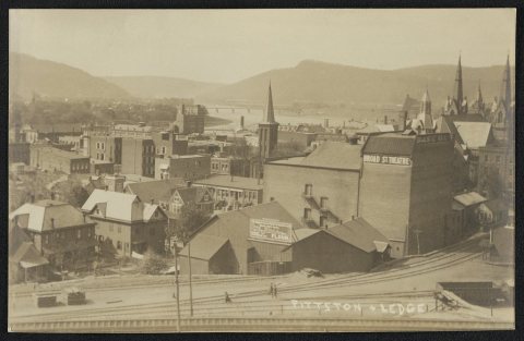 1907
 1907
 1907
 1907
 1907


