North East dates to 1800, and 41% of its homes were built before 1940
More historic than 97% of U.S. towns · #85 of 1,035 in Pennsylvania. What drives it
2 places in town are on the National Register, among them a historic district with 114 buildings. Below: 11 old photos and papers, maps from 1887 on, and the census since 1850.
On its age, its old homes and the National Register, North East is more historic than 97% of U.S. towns, #85 of 1,035 in Pennsylvania. All 3 inputs are above most U.S. towns; its share of homes from before 1940 ranks highest and its age lowest.
A+
HistoryA character grade: shown, never part of North East’s overall grade.
Pennsylvania towns list about as much on the Register as the country (a typical Pennsylvania town has 2.1 per 10,000 residents, the U.S. 2.4), so North East’s 284 sits above most of its state (92% of Pennsylvania towns have fewer) while its 115 historic buildings outnumber those of 90% of U.S. towns.
How sure. Graded on any two of the three inputs instead, the letter would range from A to A+. The pre-1940 share is a Census survey estimate (±11.3 points). Two sources give 1800.
Founding year: Wikidata (other dates in Quick answers). Homes: Census ACS 2020–24. National Register: National Park Service, May 2026 list; each listing counted once (boundary changes and added documentation belong to their listing), and a historic district counts its contributing buildings. How TownRatings grades history →
What stands out about North East’s past
Read from the archive, the National Register and the record. The page puts what stands out first.
National Park Service, National Register of Historic Places. Photos from Wikimedia Commons, credited on each place’s page.
Every building
North East, building by building, 1887–1912
Fire insurance maps drew every building, what it was made of and what it was used for, so insurers could price the risk of fire. Pick a year, then a sheet.
Passages that mention North East, cut from the printed page as they were published.
History of Erie county, Pennsylvania1884 · page 234Read the page →
Read the text
The earliest road opened after the American occupation was by Judah Colt, as agent of the Population Company, in 1797, from Freeport, on the lake near North East, to Colt's Station, and from the latter place to the Forks of French Creek, or Wattsburg, late in the season of 1798. The Eastern road through Greenfield, from North East to Wattsburg, was laid out about 1800; the ones from Waterford to Cranesville through Washington Township, and from Waterford to Bdinboro, about 1802, and the road from North East to Waterford, by way of Phillipsville, in 1804.
Text read by machine from the scan; it may contain errors.
A twentieth century history of Erie County, Pennsylvania1909 · page 337Read the page →
Read the text
The second born of their children, Isaac, remained at home with his parents until his marriage, and with his young wife he then located on a farm in Mill Creek township and lived there for eleven years. Coming then to North East township he bought and sold several farms here, and in March of 1900 became the owner of the present Wolf home in the town of North East, where he died a few years afterward, on the 15th of August, 1904. Erie county had been his home for many years, and he was known and honored to many
Text read by machine from the scan; it may contain errors.
A twentieth century history of Erie County, Pennsylvania1909 · page 212Read the page →
Read the text
Seth Loomis, the grandfather of Rufus S., moved to the town of North East during an early period in its history, and he died here on the 15th of July, 1809. His son Joel bought a large tract of land six miles south of North East, in Greenfield township, which was his home for many years, but the later part of his life was spent in the town, and during the fifteen years previous to his death he was blind.
Text read by machine from the scan; it may contain errors.
History of Erie county, Pennsylvania1884 · page 219Read the page →
Read the text
years old. Mrs. Cook departed this life Sept. 1, 1877. Our subject kept the Cook's Hotel for about fifteen years; at the same time was engaged in the carpenter's and joiner's business, employing from three to five men most of the time. He was one of a company who constructed the Lake Shore Railroad from New York State line to North East, including the building of a bridge over Twenty-Mile Creek, 580 feet long and 300 feet high, and the railroad buildings at North East. He then engaged in building three miles of plank road from Waterford to Marvin's Mills; piers and abutments across the Wabash at Vincennes, Ind. ; graded about twelve miles on the O. ifc M. R. R., and about twenty on the N. M., in
Text read by machine from the scan; it may contain errors.
Scans and text from the Internet Archive. Books published in 1930 or earlier, which are in the public domain.
Timeline
North East, 1800 to 1988
Woven from the archive, old maps, post office records, the National Register and the people born here.
Nothing in the archives for these yearsWeddings on Main Street, storms, parades, school pictures, the old store. If it’s in your family album, it belongs here.
Nothing in the archives for these yearsWeddings on Main Street, storms, parades, school pictures, the old store. If it’s in your family album, it belongs here.
Nothing in the archives for these yearsWeddings on Main Street, storms, parades, school pictures, the old store. If it’s in your family album, it belongs here.
In 1800, according to Wikidata. North East’s post office opened in 1810, and the census of 1850 counted 387 people here.
How does North East rank for history?
North East is more historic than 97% of U.S. towns, #85 of 1,035 in Pennsylvania. The History grade combines the town’s founding era, the share of homes built before 1940 and its National Register listings. It’s a character grade, so it isn’t part of the overall grade. How it works.
What is on the National Register in North East?
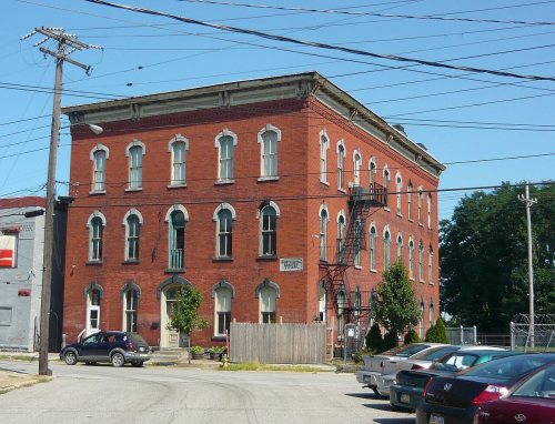
Two places: the Short's Hotel (listed 1983) and the North East Historic District (1990).
How old are the homes in North East?
41% of North East’s homes were built before 1940 (Census estimate, ±11.3 points), against a typical 18% for a Pennsylvania town; the median home was built in 1947.
Founding dates: Wikidata, Wikipedia, the U.S. post office records of Blevins & Helbock (CC0) and the Census. Homes by year built: Census ACS 2020–24. National Register of Historic Places: National Park Service (list of May 22, 2026). Old photos, postcards and papers: Wikimedia Commons, the Library of Congress and other public archives, credited on each item’s page. Maps: U.S. Geological Survey historical topographic maps (via Esri) and Sanborn fire-insurance maps (Library of Congress). History text and census tables: Wikipedia (CC BY-SA 4.0). Places that used to be: USGS Geographic Names Information System (2021).
From Wikimedia Commons (11), Wikidata (1), the National Register of Historic Places (2), Wikipedia, Wikidata and Wikipedia for famous people, U.S. Geological Survey historical maps, U.S. Census counts (via Wikipedia), the US Post Offices dataset (Blevins & Helbock), the USGS Geographic Names Information System, Sanborn fire insurance maps (Library of Congress) and old county and town histories (Internet Archive). Archive images are copied here with their credits and licenses, shown on each photo’s page. Refreshed monthly.




 1896
 1933
 1933
 1933
 1933
 1933
 1933
 1933


