Guest, Sign inJoin

Post to Hulmeville

We’ll email a one-tap link to publish your post. No password, and nothing is public until you click it.
Already a member? Sign in
–Not graded
History · Hulmeville

Hulmeville dates to 1796, and 38% of its homes were built before 1940

1 place in town is on the National Register, among them a historic district with 103 buildings. Below: 4 old photos and papers, maps from 1944 on, and the census since 1880.

1796founded
1on the National Register
38%homes built before 1940
4old photos & papers
Quick answers

How Hulmeville began

When was Hulmeville founded?

1796

Hulmeville dates its founding to 1796 (Wikidata). The census first counted it in 1880.

First census: 376 in 18802020 census: 982230 years
Founding year: Wikidata. First post office: 1809.The full story ↓

What stands out about Hulmeville’s past

Read from the archive, the National Register and the record. The page puts what stands out first.

★ What stands out · Help out

Start Hulmeville’s collection

The first neighbors to add old photos shape how Hulmeville’s history is told.

Decades since 1900 with photos
00s10s20s30s40s50s60s70s80s90s
0 of 10 decades. The empty ones are waiting for someone’s album.
On the National Register

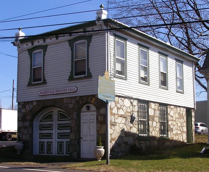
1 listing protects 103 historic buildings

The country’s official list of buildings and places worth saving.

place listed
1
National Historic Landmarks
0
none yet
historic buildings protected
103
each building in a district counts
first listed
1986
Hulmeville Historic District
Districts

Architectural styles listings

Federal1
Greek Revival1
Victorian1
Second French Empire1
Gothic Revival1
Spanish Mission1

National Park Service, National Register of Historic Places. Photos from Wikimedia Commons, credited on each place’s page.

Timeline

Hulmeville, 1796 to 1956

Woven from the archive, old maps, post office records, the National Register and the people born here.

  1. 18th century
  2. 1796
    FoundingHulmeville is established
  3. 19th century
  4. 1809Post officeThe Hulmeville post office opens
  5. 1880In the archive1940 Census Enumeration District Maps - Pennsylvania - Bucks County - Middletown - ED 9-4…
  6. 1891In the archiveAtlas of Bucks Co., Penna
  7. 20th century
  8. 1944On the mapFirst mapped by the U.S. Geological Survey
  9. 1956Post officeThe Hulmeville post office closes
The story

How Hulmeville came to be

From Wikipedia’s history of Hulmeville.

Read it all →

The Hulme family name, originally DeHoulme, is of Norman origin, dating from William the Conqueror. Members of the family originally settled in Lancashire, England, a branch later moved to Cheshire. The American family came from this branch. George Hulme Sr. and George Hulme Jr. immigrated to Bucks County from Tilston, Cheshire, about 1700, purchasing land and settled in Middletown Township, some of the family later relocating to Buckingham. John Hulme Sr., grandson of George Sr. and his son, George Hulme Jr., moved from Buckingham to Fallsington and ran a weaving business until 1796 when John Jr. purchased land along the Neshaminy Creek and called it Milford. John Jr. married Rebecca Milnor daughter of William Milnor.

Text from Wikipedia, licensed CC BY-SA 4.0.

From the old history books

What they wrote about Hulmeville, 1876–1905

Passages that mention Hulmeville, cut from the printed page as they were published.

Dunk's ferry, but we do not know that it was granted. In 1700 a road was opened from Growden's to the King's highway leading to the falls. This highway at that time was probably the road from the Poquessing that crossed the Neshaminy about Hulmeville, and which at one time was a thoroughfare from t…
The history of Bucks County, Pennsylvania1876 · page 159Read the page →
Read the text

Dunk's ferry, but we do not know that it was granted. In 1700 a road was opened from Growden's to the King's highway leading to the falls. This highway at that time was probably the road from the Poquessing that crossed the Neshaminy about Hulmeville, and which at one time was a thoroughfare from the falls to Philadelphia. Galloway's ford was on the Neshaminy above Hulmeville, and was destroyed when the dam was built, because it backed up the water so that it could not be crossed. At April term, 1703, the

Text read by machine from the scan; it may contain errors.
In September, 1871, William Tilton issued the first number of The /Squib at Hulmeville, a sheet six by nine inches. It wras printed at intervals until April, 1872, when it was enlarged to nine by twelve inches, published semi-monthly, and the name changed to The Beacon, In August of the same year i…
The history of Bucks County, Pennsylvania1876 · page 828Read the page →
Read the text

In September, 1871, William Tilton issued the first number of The /Squib at Hulmeville, a sheet six by nine inches. It wras printed at intervals until April, 1872, when it was enlarged to nine by twelve inches, published semi-monthly, and the name changed to The Beacon, In August of the same year it was doubled in size, and in January, 1873, it was changed to a weekly, the present name, Hulmeville Beacon, adopted, and again doubled in size. In July it was made a five-column paper, and on the 7th of May, 1874, a

Text read by machine from the scan; it may contain errors.
was able to give his father competent assistance and he remained with him until he attained his majority. He then located in Hulmeville, Bucks county, where for almost a quarter of a century he conducted the Hulmeville Hotel in such a manner as to show a substantial profit at the end of each year. …
History of Bucks county, Pennsylvania, from the discovery of the Delaware to the present time1905Read the page →
Read the text

was able to give his father competent assistance and he remained with him until he attained his majority. He then located in Hulmeville, Bucks county, where for almost a quarter of a century he conducted the Hulmeville Hotel in such a manner as to show a substantial profit at the end of each year. After this

Text read by machine from the scan; it may contain errors.

Scans and text from the Internet Archive. Books published in 1930 or earlier, which are in the public domain.

By decade

Hulmeville, decade by decade

2 decades in the archive, from the 1880s to the 1890s. Scroll each row; tap a photo for its story.

1900s–1990snothing yet
Nothing in the archives for these yearsWeddings on Main Street, storms, parades, school pictures, the old store. If it’s in your family album, it belongs here.
Add from your album
On the map

Hulmeville on the map, 1944 to 1993

Every edition of the U.S. Geological Survey’s map of Hulmeville. Tap a year, or press play to watch the town change.

Hulmeville on the 1944 USGS mapHulmeville on the 1953 USGS mapHulmeville on the 1966 USGS mapHulmeville on the 1973 USGS mapHulmeville on the 1993 USGS map1944Langhorne sheet · 1:24,000

U.S. Geological Survey historical topographic maps (public domain), via Esri’s collection of the scans. The red ring marks the center of Hulmeville.

Then & now

Stand where they stood

No then-and-now pairs yet. Take a photo from the same spot as an old one and they appear here side by side.

1940 Census Enumeration District Maps - Pennsylvania - Bucks County - Middletown - ED 9-48A, ED 9-48B
Retake this view1940 Census Enumeration District Maps - Pennsylvania - Bucks County - Middletown - ED 9-48A, ED 9-48B, 1880

Find the spot, match the angle, and add your photo. It becomes the first then-and-now pair on Hulmeville’s page.

Retake this view · +15
People over time

Hulmeville, census by census

02004006008001,00018801900192019401960198020002020Peak: 1,014

Between 376 and 1,014 people in every census since 1880.

15 censuses, 1880–2020.

U.S. Census Bureau decennial counts, from the census table on Hulmeville’s Wikipedia page.

Places that used to be

Lost post offices and old corners

Hulmeville had its own post office from 1809 to 1956.

Hulmeville
1809–1956
18001910today
Hamlets and corners on the map
Hulmeville Terrace

US Post Offices dataset (Blevins & Helbock, CC0). Places and cemeteries from the USGS Geographic Names Information System (2021).

Stories next door

History across the town line

Each neighbor’s History grade, on the same three inputs.

Questions about Hulmeville’s history

What year was Hulmeville founded?

In 1796, according to Wikidata. Hulmeville’s post office opened in 1809, and the census of 1880 counted 376 people here.

What is on the National Register in Hulmeville?

One place: the Hulmeville Historic District (listed 1986).

Memory lane

What the archives can’t tell you, neighbors can.

Town Square →
Start a conversation
Sources

Where this page comes from

Founding dates: Wikidata, Wikipedia, the U.S. post office records of Blevins & Helbock (CC0) and the Census. Homes by year built: Census ACS 2020–24. National Register of Historic Places: National Park Service (list of May 22, 2026). Old photos, postcards and papers: Wikimedia Commons, the Library of Congress and other public archives, credited on each item’s page. Maps: U.S. Geological Survey historical topographic maps (via Esri) and Sanborn fire-insurance maps (Library of Congress). History text and census tables: Wikipedia (CC BY-SA 4.0). Places that used to be: USGS Geographic Names Information System (2021). How TownRatings grades history →

From Wikimedia Commons (6), the National Register of Historic Places (1), Wikipedia, U.S. Geological Survey historical maps, U.S. Census counts (via Wikipedia), the US Post Offices dataset (Blevins & Helbock), the USGS Geographic Names Information System and old county and town histories (Internet Archive). Archive images are copied here with their credits and licenses, shown on each photo’s page. Refreshed monthly.