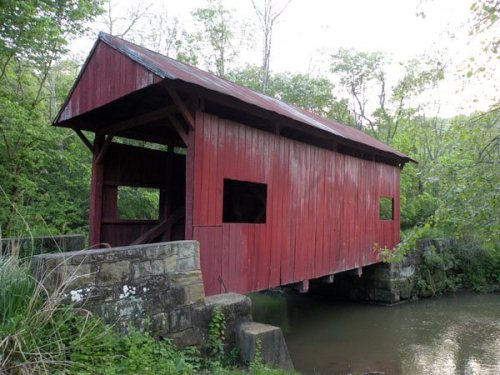
Its Register listings are the Devil's Den, McClurg Covered Bridge and the Ralston Freeman Covered Bridge. Below: 6 old photos and papers, maps from 1904 on, and the census since 1820.
On its age, its old homes and the National Register, Hanover Township is more historic than 72% of U.S. towns. All 2 inputs are above most U.S. towns; its National Register listings ranks highest and its share of homes from before 1940 lowest.
B+
HistoryA character grade: shown, never part of Hanover Township’s overall grade.
Pennsylvania towns list about as much on the Register as the country (a typical Pennsylvania town has 2.1 per 10,000 residents, the U.S. 2.4), so Hanover Township’s 8.3 sits above most of its state (74% of Pennsylvania towns have fewer) while its 2 listings outnumber those of 60% of U.S. towns.
How sure. Graded on two of the three inputs, so a change in either one moves the letter more than it would with three. The pre-1940 share is a Census survey estimate (±5.4 points).
Founding year: our sources. Homes: Census ACS 2020–24. National Register: National Park Service, May 2026 list; each listing counted once (boundary changes and added documentation belong to their listing), and a historic district counts its contributing buildings. How TownRatings grades history →
What stands out about Hanover Township’s past
Read from the archive, the National Register and the record. The page puts what stands out first.
Lost post offices, old corners, places now gone and burying grounds
Two other post offices opened and closed inside today’s town.
Paris
1831–1907
Florence
1832–1964
18301930today
Hamlets and corners on the map
FlorenceParis
Gone or out of use
Miller Airportairport
2cemeteries and burying grounds inside Hanover Township
Chestnut RidgeGrandview
US Post Offices dataset (Blevins & Helbock, CC0). Places and cemeteries from the USGS Geographic Names Information System (2021).
On the map
Hanover Township on the map, 1904 to 1977
Every edition of the U.S. Geological Survey’s map of Hanover Township. Tap a year, or press play to watch the town change.
1904Burgettstown sheet · 1:62,500
U.S. Geological Survey historical topographic maps (public domain), via Esri’s collection of the scans. The red ring marks the center of Hanover Township.
In 1727, John Digges, an Irish nobleman of Prince George's County, Maryland, obtained a grant of 10,000 acres (40 km2) of land where Hanover is now located from Charles Calvert, 5th Baron Baltimore. The area was called Digges Choice, and in 1730, a group of Catholics started the settlement that became known as the Conewego Settlement. Settlers from both Maryland and Pennsylvania began moving into the area in the 1730s. At this time, Maryland and Pennsylvania did not agree on the northern border of Maryland and the southern border of Pennsylvania, and the area that is now Hanover was in the disputed area claimed by both states. This led to numerous disputes about property ownership from the 1730s until 1760. The dispute was settled when Maryland and Pennsylvania hired British expert surveyors Charles Mason and Jeremiah Dixon to survey what became known as the Mason–Dixon line. This line …
Passages that mention Hanover Township, cut from the printed page as they were published.
20th century history of the city of Washington and Washington County, Pennsylvania1910Read the page →
Read the text
E. P. Stevenson is a substantial farmer of Hanover Township, Washington County, where he owns 191 acres of valuable land. He is locally a man of importance and is secretary of the Hanover Township road commission, of which Orrin B. Stevenson is treasurer. He is the owner of the general store at Florence, which his son manages with much success, doing a large but safe business and displaying much mercantile capacity. R. P.
Text read by machine from the scan; it may contain errors.
Scans and text from the Internet Archive. Books published in 1930 or earlier, which are in the public domain.
Timeline
Hanover Township, 1831 to 1964
Woven from the archive, old maps, post office records, the National Register and the people born here.
Nothing in the archives for these yearsWeddings on Main Street, storms, parades, school pictures, the old store. If it’s in your family album, it belongs here.
Hanover Township is more historic than 72% of U.S. towns. The History grade combines the town’s founding era, the share of homes built before 1940 and its National Register listings. It’s a character grade, so it isn’t part of the overall grade. How it works.
What is on the National Register in Hanover Township?
Two places: the Devil's Den, McClurg Covered Bridge (listed 1979) and the Ralston Freeman Covered Bridge (1979).
How old are the homes in Hanover Township?
15% of Hanover Township’s homes were built before 1940 (Census estimate, ±5.4 points), against a typical 18% for a Pennsylvania town; the median home was built in 1976.
Founding dates: Wikidata, Wikipedia, the U.S. post office records of Blevins & Helbock (CC0) and the Census. Homes by year built: Census ACS 2020–24. National Register of Historic Places: National Park Service (list of May 22, 2026). Old photos, postcards and papers: Wikimedia Commons, the Library of Congress and other public archives, credited on each item’s page. Maps: U.S. Geological Survey historical topographic maps (via Esri) and Sanborn fire-insurance maps (Library of Congress). History text and census tables: Wikipedia (CC BY-SA 4.0). Places that used to be: USGS Geographic Names Information System (2021).
From Wikimedia Commons (6), the National Register of Historic Places (2), Wikipedia, U.S. Geological Survey historical maps, U.S. Census counts (via Wikipedia), the US Post Offices dataset (Blevins & Helbock), the USGS Geographic Names Information System and old county and town histories (Internet Archive). Archive images are copied here with their credits and licenses, shown on each photo’s page. Refreshed monthly.


 1917
 1917