Guest, Sign inJoin

Post to Franklin

We’ll email a one-tap link to publish your post. No password, and nothing is public until you click it.
Already a member? Sign in
–Not graded
History · Franklin

Franklin dates to 1868, and 54% of its homes were built before 1940

Below: 3 old photos and papers, maps from 1904 on, and the census since 1870.

1868founded
0on the National Register
54%homes built before 1940
3old photos & papers
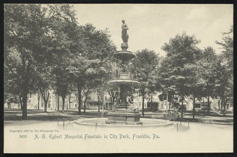
From Franklin’s archive · credits on each photo
Quick answers

How Franklin began

When was Franklin founded?

1868

Franklin dates its founding to 1868 (Wikidata). The census first counted it in 1870.

First census: 426 in 18702020 census: 278158 years
Founding year: Wikidata.The full story ↓

What stands out about Franklin’s past

Read from the archive, the National Register and the record. The page puts what stands out first.

★ What stands out · Help out

Start Franklin’s collection

The first neighbors to add old photos shape how Franklin’s history is told.

Decades since 1900 with photos
00s10s20s30s40s50s60s70s80s90s
2 of 10 decades. The empty ones are waiting for someone’s album.
The story

How Franklin came to be

From Wikipedia’s history of Franklin.

Read it all →

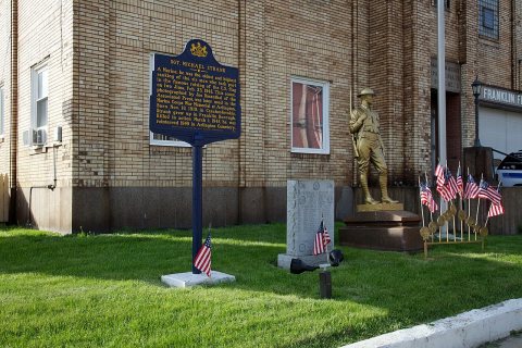
Sgt. Michael Strank, a Rusyn American and one of the US Marines pictured in the photograph Raising the Flag on Iwo Jima, was raised in Franklin.

Text from Wikipedia, licensed CC BY-SA 4.0.

People over time

Franklin, census by census

05001,0001,5002,0002,5001880190019201940196019802000Peak: 2,632

Peaked at 2,632 in 1920; 323 people lived here in 2010.

15 censuses, 1870–2010.

U.S. Census Bureau decennial counts, from the census table on Franklin’s Wikipedia page.

From the old history books

What they wrote about Franklin, 1846–1905

Passages that mention Franklin, cut from the printed page as they were published.

sentatives of the Commonwealth of Pennsylvania in General Assembly met, and it is hereby enacted by the authority of the same, That the act, entitled "An act to repeal an act incorporating the borough of Waynesburg, in the county of Franklin, and for other purposes/' passed the thirtieth day of Mar…
Waynesboro1900 · page 386Read the page →
Read the text

sentatives of the Commonwealth of Pennsylvania in General Assembly met, and it is hereby enacted by the authority of the same, That the act, entitled "An act to repeal an act incorporating the borough of Waynesburg, in the county of Franklin, and for other purposes/' passed the thirtieth day of March, one thousand eight hundred and twenty-four, be and the same is hereby repealed; and the act, entitled "An act to incorporate the town of Waynesburg, in the county of Franklin, into a

Text read by machine from the scan; it may contain errors.
He was a pioneer in the iron industry in Franklin county, and built and conducted what was known as "Loudon Forge.'' above the village of Fort Loudon, where he made his home. He was one of the petitioners for the new county of Franklin in 1784. and was the first justice of the peace for Peters town…
Biographical annals of Franklin county, Pennsylvania1905Read the page →
Read the text

He was a pioneer in the iron industry in Franklin county, and built and conducted what was known as "Loudon Forge.'' above the village of Fort Loudon, where he made his home. He was one of the petitioners for the new county of Franklin in 1784. and was the first justice of the peace for Peters township appointed after the erection of the

Text read by machine from the scan; it may contain errors.
outskirts of the "Conococheague settlement," lying just about three miles north by west of the present town of Greencastle, is a familiar one to every school child in Franklin county to-day. It is an event familiar because commemorated, and it stands forth in strong contrast with the other historic…
Waynesboro1900 · page 162Read the page →
Read the text

outskirts of the "Conococheague settlement," lying just about three miles north by west of the present town of Greencastle, is a familiar one to every school child in Franklin county to-day. It is an event familiar because commemorated, and it stands forth in strong contrast with the other historical events far more important, but now buried in oblivion because of the indifference and, may it be called, lack of patriotism of a past generation. The

Text read by machine from the scan; it may contain errors.
places, till they extended from the "Long, Crooked River"* to the Maryland Province, about the year 1736. Several hundred names of the first settlers in this valley will be given when speaking of Cumberland and Franklin counties. Passing, it might be remarked, that all the earliest settlements made…
The history and topography of Dauphin, Cumberland, Franklin, Bedford, Adams, and Perry counties [Pennsylvania]1846 · page 36Read the page →
Read the text

places, till they extended from the "Long, Crooked River"* to the Maryland Province, about the year 1736. Several hundred names of the first settlers in this valley will be given when speaking of Cumberland and Franklin counties. Passing, it might be remarked, that all the earliest settlements made in Lancaster, York and Cumberland, were commenced when the Indians were still numerous ; when they, and the white settlers chased, in common, the deer, the bear, and

Text read by machine from the scan; it may contain errors.

Scans and text from the Internet Archive. Books published in 1930 or earlier, which are in the public domain.

Timeline

Franklin, 1868 to 1920

Woven from the archive, old maps, post office records, the National Register and the people born here.

  1. 19th century
  2. 1868
    FoundingFranklin is established
  3. 20th century
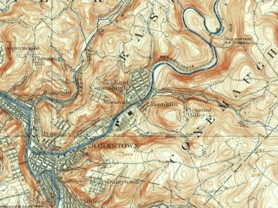
  4. 1904On the mapFirst mapped by the U.S. Geological Survey
  5. 1905In the archiveScene on the Allegheny
  6. 1918In the archiveWoodwork, checkerboard table for Y.M.C.A
  7. 1920CensusPopulation peaks at 2,632
By decade

Franklin, decade by decade

2 decades in the archive, from the 1900s to the 1910s. Scroll each row; tap a photo for its story.

1920s–1990snothing yet
Nothing in the archives for these yearsWeddings on Main Street, storms, parades, school pictures, the old store. If it’s in your family album, it belongs here.
Add from your album
On the map

Franklin on the map, 1904 to 1972

Every edition of the U.S. Geological Survey’s map of Franklin. Tap a year, or press play to watch the town change.

Franklin on the 1904 USGS mapFranklin on the 1964 USGS mapFranklin on the 1972 USGS map1904Johnstown sheet · 1:62,500

U.S. Geological Survey historical topographic maps (public domain), via Esri’s collection of the scans. The red ring marks the center of Franklin.

Then & now

Stand where they stood

No then-and-now pairs yet. Take a photo from the same spot as an old one and they appear here side by side.

Scene on the Allegheny
Retake this viewScene on the Allegheny, 1905

Find the spot, match the angle, and add your photo. It becomes the first then-and-now pair on Franklin’s page.

Retake this view · +15
Stories next door

History across the town line

Each neighbor’s History grade, on the same three inputs.

Questions about Franklin’s history

What year was Franklin founded?

In 1868, according to Wikidata. the census of 1870 counted 426 people here.

Memory lane

What the archives can’t tell you, neighbors can.

Town Square →
Start a conversation
Sources

Where this page comes from

Founding dates: Wikidata, Wikipedia, the U.S. post office records of Blevins & Helbock (CC0) and the Census. Homes by year built: Census ACS 2020–24. National Register of Historic Places: National Park Service (list of May 22, 2026). Old photos, postcards and papers: Wikimedia Commons, the Library of Congress and other public archives, credited on each item’s page. Maps: U.S. Geological Survey historical topographic maps (via Esri) and Sanborn fire-insurance maps (Library of Congress). History text and census tables: Wikipedia (CC BY-SA 4.0). Places that used to be: USGS Geographic Names Information System (2021). How TownRatings grades history →

From Wikimedia Commons (3), the Library of Congress (3), Wikipedia, U.S. Geological Survey historical maps, U.S. Census counts (via Wikipedia), the USGS Geographic Names Information System and old county and town histories (Internet Archive). Archive images are copied here with their credits and licenses, shown on each photo’s page. Refreshed monthly.