


The story
Read it all →How Conneaut Township came to be
From Wikipedia’s history of Conneaut Township.
The Harrington Covered Bridge was listed on the National Register of Historic Places in 1980.
Text from Wikipedia, licensed CC BY-SA 4.0.
Each edition grades its towns against each other only.
More historic than 87% of U.S. towns · #234 of 1,035 in Pennsylvania. What drives it
Its Register listing is the Harrington Covered Bridge. Below: maps from 1900 on and the census since 1980.
More historic than 87% of U.S. towns, on its age, its old homes and the National Register.
On its age, its old homes and the National Register, Conneaut Township is more historic than 87% of U.S. towns, #234 of 1,035 in Pennsylvania. All 2 inputs are above most U.S. towns; its share of homes from before 1940 ranks highest and its National Register listings lowest.
Pennsylvania towns list about as much on the Register as the country (a typical Pennsylvania town has 2.1 per 10,000 residents, the U.S. 2.4), so Conneaut Township’s 2.5 sits near the middle of its state (59% of Pennsylvania towns have fewer) while its 1 listings outnumber those of 51% of U.S. towns.
Founding year: our sources. Homes: Census ACS 2020–24. National Register: National Park Service, May 2026 list; each listing counted once (boundary changes and added documentation belong to their listing), and a historic district counts its contributing buildings. How TownRatings grades history →
Read from the archive, the National Register and the record. The page puts what stands out first.
Five other post offices opened and closed inside today’s town.
US Post Offices dataset (Blevins & Helbock, CC0). Places and cemeteries from the USGS Geographic Names Information System (2021).
The first neighbors to add old photos shape how Conneaut Township’s history is told.
Every edition of the U.S. Geological Survey’s map of Conneaut Township. Tap a year, or press play to watch the town change.

U.S. Geological Survey historical topographic maps (public domain), via Esri’s collection of the scans. The red ring marks the center of Conneaut Township.
From Wikipedia’s history of Conneaut Township.
The Harrington Covered Bridge was listed on the National Register of Historic Places in 1980.
Text from Wikipedia, licensed CC BY-SA 4.0.
Passages that mention Conneaut Township, cut from the printed page as they were published.
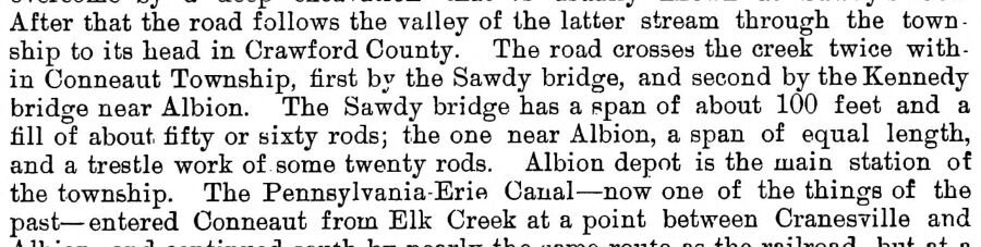
After that the road follows the valley of the latter stream through the town - ship to its head in Crawford County. The road crosses the creek twice within Conneaut Township, first by the Sawdy bridge, and second by the Kennedy brido-e near Albion. The Sawdy bridge has a span of about 100 feet and a fill of about fifty or sixty rods; the one near Albion, a span of equal length, and a trestle work of some twenty rods. Albion depot is the main station of the township. The Pennsylvania-Erie Canal — now one of the things of the past — entered Conneaut from Elk Creek at a point between Cranesville and
Text read by machine from the scan; it may contain errors.
Our subject was thoroughly educated in A.shtabula and Erie Counties, read medicine, and foUowetl Ills profession until his health failed, when he moved to Conneaut Township, Erie County, in October, 1861. In 1863, he joined the Union army as Hospital Steward, in which capacity he served until August, 1863. For a few years, he followed mercantile trade, but his poor health compelled him to abandon this, and for the past few years he ha.i been farming. He moved to Girard in 1873, and in 1881 occupied his present farm, consisting of seventy-five acres. He has held various township offices, and is connected witli the Methodist Episcopal Church. Mr. Batcheler was united in marriage, in this
Text read by machine from the scan; it may contain errors.Scans and text from the Internet Archive. Books published in 1930 or earlier, which are in the public domain.
Woven from the archive, old maps, post office records, the National Register and the people born here.
 On the mapFirst mapped by the U.S. Geological Survey
The country’s official list of buildings and places worth saving.
National Park Service, National Register of Historic Places. Photos from Wikimedia Commons, credited on each place’s page.
Between 1,893 and 4,290 people in every census since 1980.
5 censuses, 1980–2020.
U.S. Census Bureau decennial counts, from the census table on Conneaut Township’s Wikipedia page.
Each neighbor’s History grade, on the same three inputs.
Conneaut Township is more historic than 87% of U.S. towns, #234 of 1,035 in Pennsylvania. The History grade combines the town’s founding era, the share of homes built before 1940 and its National Register listings. It’s a character grade, so it isn’t part of the overall grade. How it works.
One place: the Harrington Covered Bridge (listed 1980).
38% of Conneaut Township’s homes were built before 1940 (Census estimate, ±8.1 points), against a typical 18% for a Pennsylvania town; the median home was built in 1968.
What the archives can’t tell you, neighbors can.
Founding dates: Wikidata, Wikipedia, the U.S. post office records of Blevins & Helbock (CC0) and the Census. Homes by year built: Census ACS 2020–24. National Register of Historic Places: National Park Service (list of May 22, 2026). Old photos, postcards and papers: Wikimedia Commons, the Library of Congress and other public archives, credited on each item’s page. Maps: U.S. Geological Survey historical topographic maps (via Esri) and Sanborn fire-insurance maps (Library of Congress). History text and census tables: Wikipedia (CC BY-SA 4.0). Places that used to be: USGS Geographic Names Information System (2021).
From Wikimedia Commons (5), Wikidata (2), the National Register of Historic Places (1), Wikipedia, U.S. Geological Survey historical maps, U.S. Census counts (via Wikipedia), the US Post Offices dataset (Blevins & Helbock), the USGS Geographic Names Information System and old county and town histories (Internet Archive). Archive images are copied here with their credits and licenses, shown on each photo’s page. Refreshed monthly.
 2024
 2022
 2014
 2014
 2014
