Chambersburg dates to 1734, and 24% of its homes were built before 1940
More historic than 97% of U.S. towns · #81 of 1,035 in Pennsylvania. What drives it
11 places in town are on the National Register, among them two historic districts with 176 buildings between them. Below: 52 old photos and papers, maps from 1887 on, and the census since 1810.
Founding year: Wikidata. First post office: 1788.The full story ↓
History grade
What drives Chambersburg’s History grade
On its age, its old homes and the National Register, Chambersburg is more historic than 97% of U.S. towns, #81 of 1,035 in Pennsylvania. All 3 inputs are above most U.S. towns; its age ranks highest and its share of homes from before 1940 lowest.
A+
HistoryA character grade: shown, never part of Chambersburg’s overall grade.
Pennsylvania towns list about as much on the Register as the country (a typical Pennsylvania town has 2.1 per 10,000 residents, the U.S. 2.4), so Chambersburg’s 86.0 sits above most of its state (88% of Pennsylvania towns have fewer) while its 192 historic buildings outnumber those of 93% of U.S. towns.
NoteThe founding year comes from Wikidata alone; no second source gives 1734.
How sure. Graded on any two of the three inputs instead, the letter would range from A to A+. The pre-1940 share is a Census survey estimate (±3.8 points).
Founding year: Wikidata (other dates in Quick answers). Homes: Census ACS 2020–24. National Register: National Park Service, May 2026 list; each listing counted once (boundary changes and added documentation belong to their listing), and a historic district counts its contributing buildings. How TownRatings grades history →
What stands out about Chambersburg’s past
Read from the archive, the National Register and the record. The page puts what stands out first.
Nothing in the archives for these yearsWeddings on Main Street, storms, parades, school pictures, the old store. If it’s in your family album, it belongs here.
National Park Service, National Register of Historic Places. Photos from Wikimedia Commons, credited on each place’s page.
Every building
Chambersburg, building by building, 1887–1924
Fire insurance maps drew every building, what it was made of and what it was used for, so insurers could price the risk of fire. Pick a year, then a sheet.
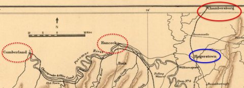
Native Americans living or hunting in the area during the 18th century included the six Iroquois tribes of a confederacy known as the Iroquois League or Haudenosaunee, the Lenape, and the Shawnee. The Lenape lived mostly to the east, with the Iroquois to the north, and the Shawnee to the south. Their traders, hunters, and warriors traveled on the north-south route sometimes called the "Virginia path" through the Cumberland Valley, from New York through what became Carlisle and Shippensburg, then through what would become Hagerstown, Maryland, crossing the Potomac River into the Shenandoah Valley.
Passages that mention Chambersburg, cut from the printed page as they were published.
History of Franklin county, Pennsylvania1887 · page 805Read the page →
Read the text
Martha (Snider) Eby, natives of Pennsylvania and of German descent. His great-grandfather was born in Germany. Jacob Eby, after his marriage, moved to Guilford Township and kept a hotel for seven years on the Baltimore and Chambersburg pike (when stages ran from Baltimore to Chambersburg), and he used to stable from twenty-five to thirty teams in one night. In 1840 he moved two miles west of Chambersburg, on the Bedford and Chambersburg pike, and kept hotel twenty-two years; bought 120 acres of land and lived there until 1853, when he moved to Chambersburg, where he bought property and
Text read by machine from the scan; it may contain errors.
History of Franklin county, Pennsylvania1887 · page 151Read the page →
Read the text
In 1764 Col. Chambers laid out the town of Chambersburg, whose history is sketched elsewhere in this volume. The history of this sturdy early settler is the history of the county and of the commonwealth for more than half a century. From the time he landed at the Falling Spring till his declining health rendered further activity impossible, he was the acknowledged leader of the people in all civil, military and religious movements.
Text read by machine from the scan; it may contain errors.
Scans and text from the Internet Archive. Books published in 1930 or earlier, which are in the public domain.
Timeline
Chambersburg, 1734 to 1998
Woven from the archive, old maps, post office records, the National Register and the people born here.
Chambersburg’s post office has been open since 1788.
8cemeteries and burying grounds inside Chambersburg
Cedar GroveChambersburg JewishFalling Spring Presbyterian ChurchFirst Evangelical Lutheran Church of ChambersburgLincolnStoufferstownTrinity Episcopal Church ColumbariumZion Reformed Church
US Post Offices dataset (Blevins & Helbock, CC0). Places and cemeteries from the USGS Geographic Names Information System (2021).
Help out
Finish Chambersburg’s story
Most archives stop around 1920. The photos from after that are in family albums, not libraries.
Decades since 1900 with photos
00s10s20s30s40s50s60s70s80s90s
4 of 10 decades. The empty ones are waiting for someone’s album.
In 1734, according to Wikidata. Chambersburg’s post office opened in 1788, and the census of 1810 counted 1,304 people here.
How does Chambersburg rank for history?
Chambersburg is more historic than 97% of U.S. towns, #81 of 1,035 in Pennsylvania. The History grade combines the town’s founding era, the share of homes built before 1940 and its National Register listings. It’s a character grade, so it isn’t part of the overall grade. How it works.
What is on the National Register in Chambersburg?
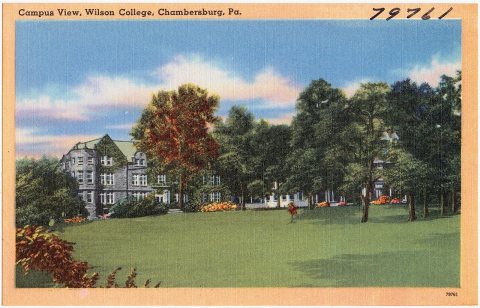
11 listings: 8 buildings, among them the Franklin County Jail (listed 1970, the first), 2 historic districts, the Chambersburg Historic District and the Wilson College, with 176 contributing buildings, and 1 object. 192 historic buildings in all.
How old are the homes in Chambersburg?
24% of Chambersburg’s homes were built before 1940 (Census estimate, ±3.8 points), against a typical 18% for a Pennsylvania town; the median home was built in 1963.
Founding dates: Wikidata, Wikipedia, the U.S. post office records of Blevins & Helbock (CC0) and the Census. Homes by year built: Census ACS 2020–24. National Register of Historic Places: National Park Service (list of May 22, 2026). Old photos, postcards and papers: Wikimedia Commons, the Library of Congress and other public archives, credited on each item’s page. Maps: U.S. Geological Survey historical topographic maps (via Esri) and Sanborn fire-insurance maps (Library of Congress). History text and census tables: Wikipedia (CC BY-SA 4.0). Places that used to be: USGS Geographic Names Information System (2021).
From Wikimedia Commons (31), the Library of Congress (21), Wikidata (1), the National Register of Historic Places (11), Wikipedia, Wikidata and Wikipedia for famous people, U.S. Geological Survey historical maps, U.S. Census counts (via Wikipedia), the US Post Offices dataset (Blevins & Helbock), the USGS Geographic Names Information System, Sanborn fire insurance maps (Library of Congress) and old county and town histories (Internet Archive). Archive images are copied here with their credits and licenses, shown on each photo’s page. Refreshed monthly.


 1862
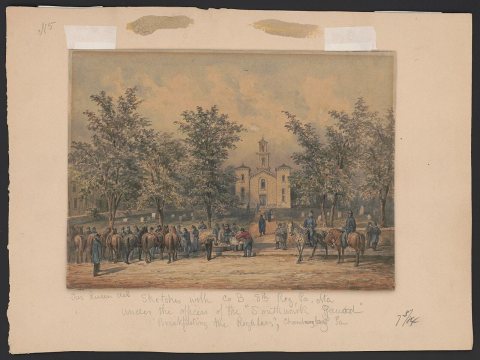 1862
 1862
 1862
 1862
 1864
 1864
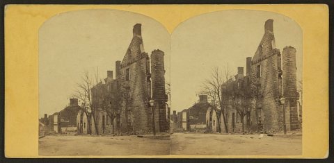 1864
 1864
 1864
 1864
 1864
 1864
 1864
 1864
 1864
 1864
 1864
 1864
 1864
 1864
 1864
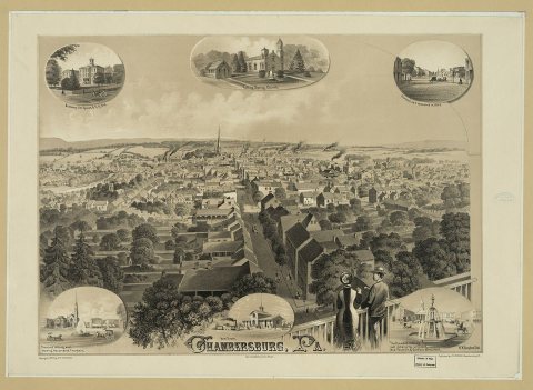 1877
 1890
 1894
 1894
 1902
 1905
 1909
 c. 1910
 1912
 1912
 1916
 1923
 c. 1930
 c. 1930
 c. 1930
 c. 1930
 c. 1930
 c. 1930
 c. 1930
 c. 1930
 c. 1930
 c. 1930
 c. 1930
 c. 1930
 c. 1930
 c. 1930
 c. 1930
 c. 1930
 c. 1930
 c. 1930