Catasauqua dates to 1768, and 52% of its homes were built before 1940
Among the most historic 1% of U.S. towns · #23 of 1,035 in Pennsylvania. What drives it
3 places in town are on the National Register, among them the George Taylor House, a National Historic Landmark, and two historic districts with 153 buildings between them. Below: 8 old photos and papers, maps from 1885 on, and the census since 1860.
Founding year: Wikidata. First post office: 1844.The full story ↓
History grade
What drives Catasauqua’s History grade
On its age, its old homes and the National Register, Catasauqua is among the most historic 1% of U.S. towns, #23 of 1,035 in Pennsylvania. All 2 inputs put Catasauqua near the top nationally; its share of homes from before 1940 ranks highest.
A+
HistoryA character grade: shown, never part of Catasauqua’s overall grade.
Pennsylvania towns list about as much on the Register as the country (a typical Pennsylvania town has 2.1 per 10,000 residents, the U.S. 2.4), so Catasauqua’s 235 sits above most of its state (91% of Pennsylvania towns have fewer) while its 154 historic buildings outnumber those of 92% of U.S. towns.
NoteThe founding year comes from Wikidata alone; no second source gives 1768.
How sure. Graded on two of the three inputs, so a change in either one moves the letter more than it would with three. The pre-1940 share is a Census survey estimate (±7.6 points).
Founding year: Wikidata (other dates in Quick answers). Homes: Census ACS 2020–24. National Register: National Park Service, May 2026 list; each listing counted once (boundary changes and added documentation belong to their listing), and a historic district counts its contributing buildings. How TownRatings grades history →
What stands out about Catasauqua’s past
Read from the archive, the National Register and the record. The page puts what stands out first.
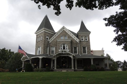
George Taylor, signer of the Declaration of Independence, built a Georgian stone house in 1768 in what is now Catasauqua. The George Taylor House has been named a National Historic Landmark, a showpiece of the community's rich historical heritage. At the time, the area of present-day Catasaqua was referred to as Biery's Port.
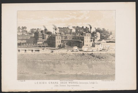
In 1840, the anthracite iron industry was found in Biery's Port in present-day Catasaqua, making Catasaqua a birthplace of the American Industrial Revolution.
Passages that mention Catasauqua, cut from the printed page as they were published.
A history of Lehigh County, Pennsylvania, from the earliest settlements to the present time, including much valuable information for the use of schools, families, libraries1902 · page 40Read the page →
Read the text
VILLAGES — Centreville is a suburb of Macungie, contains a hotel, store, schoolhouse and number of dwelling houses, post cffice Macungie, electric railway passes through the town. Population 360. Albuitis on the East Pennsylvania Branch of the P. & R. railroad and the terminus of the Catasauqua & Fogelsville branch of the same railroad, is a thriving town and has several stores hotels, silk mill, .shirt factory, post office, school house containing four schools'; was founded in 1857 and its population in 1900 was 780. East Texas is a small village, seven miles from Allentowu on the line of the Allentown & Kutztown
Text read by machine from the scan; it may contain errors.
Early history and reminiscences of Catasauqua in Pennsylvania1914 · page 100Read the page →
Read the text
3, 1851, for the incorporation of Catasauqua into a Borough. The decree of the Court was made Feb. 1, 1853, which provided as follows : That the village of Catasauqua, and the territory in and around the same as comprised within the following boundaries, to wit: Beginning at a point in the River Lehigh at low water mark, thence through land of Paul Faust, on the line dividing the said county of Lehigh from the county of Northampton, to the public road leading from bridge to
Text read by machine from the scan; it may contain errors.
Early history and reminiscences of Catasauqua in Pennsylvania1914 · page 16Read the page →
Read the text
David Thomas came here in 1839 and he started the town of Catasauqua, but it was a half-mile across the fields from his farm to the works, with the Peter's farm between. There was no road where Front street now is; the road led from the dam along the canal west of the house, crossed present Front street where Chapel street intersects, and was laid out at an early day in a direction due east, passing where the chapel
Text read by machine from the scan; it may contain errors.
History of Lehigh county, Pennsylvania and a genealogical and biographical record of its families1914 · page 798Read the page →
Read the text
on railroads, including locating the central line of the Lehigh Valley Railroad between Alentown and Easton, the first train over which was run in 1855, and the Catasauqua and Fogelsville and East Penn Railroads and assisted in making a topographical survey. In 1862 he entered the employ of G. A. Aschbach, who was then city engineer, and assisted in distributing the maps of the
Text read by machine from the scan; it may contain errors.
Scans and text from the Internet Archive. Books published in 1930 or earlier, which are in the public domain.
Timeline
Catasauqua, 1768 to 1971
Woven from the archive, old maps, post office records, the National Register and the people born here.
Nothing in the archives for these yearsWeddings on Main Street, storms, parades, school pictures, the old store. If it’s in your family album, it belongs here.
Fire insurance maps drew every building, what it was made of and what it was used for, so insurers could price the risk of fire. Pick a year, then a sheet.
In 1768, according to Wikidata. Catasauqua’s post office opened in 1844, and the census of 1860 counted 1,932 people here.
How does Catasauqua rank for history?
Catasauqua is among the most historic 1% of U.S. towns, #23 of 1,035 in Pennsylvania. The History grade combines the town’s founding era, the share of homes built before 1940 and its National Register listings. It’s a character grade, so it isn’t part of the overall grade. How it works.
What is on the National Register in Catasauqua?
Three places: the George Taylor House (listed 1971), the Catasauqua Residential Historic District (1984) and the Biery's Port Historic District (1984).
How old are the homes in Catasauqua?
52% of Catasauqua’s homes were built before 1940 (Census estimate, ±7.6 points), against a typical 18% for a Pennsylvania town; the median home was built in 1938.
Founding dates: Wikidata, Wikipedia, the U.S. post office records of Blevins & Helbock (CC0) and the Census. Homes by year built: Census ACS 2020–24. National Register of Historic Places: National Park Service (list of May 22, 2026). Old photos, postcards and papers: Wikimedia Commons, the Library of Congress and other public archives, credited on each item’s page. Maps: U.S. Geological Survey historical topographic maps (via Esri) and Sanborn fire-insurance maps (Library of Congress). History text and census tables: Wikipedia (CC BY-SA 4.0). Places that used to be: USGS Geographic Names Information System (2021).
From Wikimedia Commons (13), the Library of Congress (4), Wikidata (1), the National Register of Historic Places (3), Wikipedia, Wikidata and Wikipedia for famous people, U.S. Geological Survey historical maps, U.S. Census counts (via Wikipedia), the US Post Offices dataset (Blevins & Helbock), the USGS Geographic Names Information System, Sanborn fire insurance maps (Library of Congress) and old county and town histories (Internet Archive). Archive images are copied here with their credits and licenses, shown on each photo’s page. Refreshed monthly.


 ★ Landmark


 1857
 Date?
 Date?
 Date?
 2025
 2021
 2017
 2017
 2017
 2014
 2012
 2008
 2008
