
Wooden deer, 2010
Sunriver’s story
Sunriver in pictures
Census counts: 744 in 1990, 2,023 in 2020. The archive holds 12 old photos and papers going back to 2010 and 3 maps from 1935 on.
Explore the history →Each edition grades its towns against each other only.

A town of 1,488.
The best of Sunriver’s subject grades are an A for health and schools and an A− for the outdoors; the weakest is a D for cost of living. 71% of adults 25 and older hold a bachelor’s degree or more in Sunriver, above both the Oregon town median (27%) and the median of U.S. towns (29%). Only 11 of Oregon’s 228 towns score higher on health. 16% of the land in Sunriver is conserved, where Oregon’s towns sit at 4.4% and U.S. towns at 4.3%. Sunriver has 1 place on the National Register. Sunriver has fewer than 2,500 residents, so it gets subject grades but no overall grade.
Where Sunriver beats most towns.
| Widest gap | Sunriver | OR |
|---|---|---|
| Fewer uninsured adults | 3.6% | 8.5% |
| School | Grades | Students |
|---|---|---|
| Three Rivers Elementary School | K–8 | 421 |
1,393 counted in 2010 and 2,023 in 2020.
U.S. Census 2010 & 2020 counts
Each subject compared with towns across the country (schools within Oregon), ordered by how far Sunriver is from typical.
How TownRatings grades towns →
Census counts: 744 in 1990, 2,023 in 2020. The archive holds 12 old photos and papers going back to 2010 and 3 maps from 1935 on.
Explore the history →Sunriver is unincorporated, so Deschutes County and regional agencies provide most services.
EPA SDWIS (Oct 9, 2026) · HIFLD + EIA-861 2025 · Census 2020 ZCTAs · NCES 2024–25 · registration: vote.gov, updated Oct 2, 2026.
Ordered by what stands out in Sunriver.
Its public schools are run by Bend-LaPine Administrative SD 1. Its one school is below.
| School | Level | Students | Letter |
|---|---|---|---|
| Three Rivers Elementary SchoolLargest public elementary schoolGrades K–8 | Grades K–8 | 421 | B− |
NCES · EDFacts · graded within OR on state tests and graduation
Most working residents leave Sunriver for work: only 12% work in town. Jobs based in Sunriver grew to 1,498 in 2023, 280 more than in 2013. 6.7% of Sunriver residents live below the poverty line.
| Sunriver | Oregon towns | U.S. towns | |
|---|---|---|---|
| Below the poverty line | 6.7% | 11% | 9.6% |
| Average trip to work | 25 minutes | 23 minutes | 25 minutes |
| Working residents who work in town | 12% | 9.8% | 8% |
Census LEHD 2023 · ACS
10% of adults report frequent mental distress in Sunriver. Only 3 of the 143 Oregon towns we compare have a lower share of adults who say their health is fair or poor than Sunriver. 12% of adults report frequent physical distress in Sunriver.
| Sunriver | Oregon towns | U.S. towns | |
|---|---|---|---|
| Frequent mental distress (CDC PLACES) | 10% | 18% | 17% |
| Sleep under 7 hours (CDC PLACES) | 20% | 32% | 36% |
| Yearly checkup (CDC PLACES) | 84% | 72% | 79% |
| Binge drink (CDC PLACES) | 11% | 15% | 16% |
| What stands out | Sunriver | OR |
|---|---|---|
| Fewer uninsured adults | 3.6% | 8.5% |
| Fewer older adults who have lost all their teeth | 5.9% | 12.5% |
| More adults who have had cancer | 17.3% | 8.9% |
CDC PLACES 2025 · modeled estimates for adults · CMS · HRSA
Expected storm and flood damage is higher than in 78% of U.S. communities.
FEMA National Risk Index · OpenFEMA
Sunriver has chilly winters and pleasant summers, with very little rain. July afternoons reach 83°, January nights drop to 23° and about 22 inches of snow falls in a winter.
NOAA U.S. Climate Normals, 1991–2020
11 miles of trail in 5 parks and preserves. The trail density in Sunriver is 1.3 miles per square mile.
| Biggest places to walk | Trails | Acres |
|---|---|---|
| 1. Fort Rock Park | — | 16 |
| 2. Mary McCallum Park | — | 9 |
| 3. Ponderosa Park | — | 1 |
Trails & parks © OpenStreetMap contributors · Conserved land: USGS PAD-US
FBI crime data, 2025 · crimes reported to police
Among 143 Oregon towns, just 3 have a higher share of households owning their home than Sunriver. The median sale price was $785,000 in May 2026.
Census ACS, 2020–24 · Zillow Home Value Index · Redfin Data Center
Museums, parks, gardens and other places to visit around Sunriver. Close and well known come first.
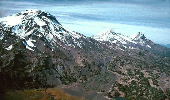 23 mi MountainThree Sisters
 16 mi MountainNewberry Volcano16 mi Park & preserveNewberry National Volcanic Monument
 37 mi State parkSmith Rock State Park15 mi Ski areaMt. Bachelor128 runs · 3,233 ft vertical
 7 mi MuseumHigh Desert Museum150K visitors a year
Three Sisters: USGS photo by Lyn Topinka, Public domain · Newberry Volcano: USGS photo by Lyn Topinka, Public domain · Newberry National Volcanic Monument: USGS photo by Lyn Topinka, Public domain · Smith Rock State Park: Max Schwarz, CC BY-SA 2.5 · High Desert Museum: Another Believer, CC BY-SA 3.0
2 within 15 miles of the center of Sunriver
About 0 of every 100 Sunriver residents are enrolled in college, against 6 across Oregon.
In a town this size, neighbors are the best guide. Ask them anything.
Unincorporated community in the state of Oregon, United States
Sunriver is a census-designated place and 3,300-acre (13 km2) planned residential and resort community in Deschutes County, Oregon, United States. As of the 2020 census it had a population of 2,023, an increase from 1,393 in 2010. It is part of the Bend Metropolitan Statistical Area, located on the eastern side of the Deschutes River, about fifteen miles (25 km) south of Bend at the base of the Cascade Range. Sunriver consists of residential homesites and common areas, recreational facilities, the Sunriver Resort and a commercial development known as The Village at Sunriver.
From Wikipedia, licensed CC BY-SA 4.0 · facts via Wikidata (CC0)
Short answers, built from the data on this page.
Yes. The typical home is worth about $728,000, 48% above the Oregon typical home. Cost of living, which also weighs rents, property taxes and how many households pay 30% or more of their income for housing, grades D.


