140 years in pictures
Census counts: 536 in 1910, 99,178 in 2020. The archive holds 6 old photos and papers going back to 1900 and 3 maps from 1962 on.
28 places on the National Register of Historic Places.
- 1886Bend is settled
Each edition grades its towns against each other only.

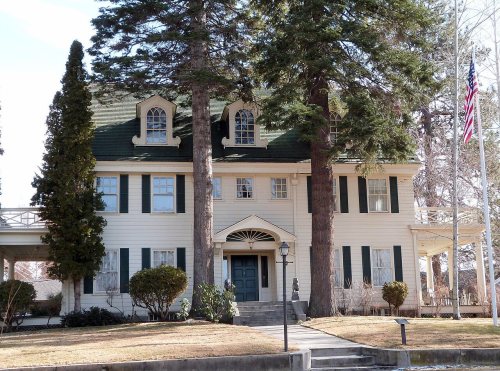
Bend is a city of 107,342, and it grades B+ overall, ranked 21st of 142 in Oregon. Residents are healthier than 91% of U.S. towns on CDC estimates and its public schools beat 88% of Oregon towns on state tests and graduation. The trade-off: homes are expensive, about $721K for a typical one and 8 times the Bend metro’s $90K median household income. 60% of working residents work locally in Bend, above both Oregon’s towns (9.5%) and U.S. towns (8%). Only 5 of Oregon’s 228 towns score higher on hazard risk. Its National Register listings include Rock O' the Range Bridge and Reid School.
Where Bend beats most towns.
Census counts: 536 in 1910, 99,178 in 2020. The archive holds 6 old photos and papers going back to 1900 and 3 maps from 1962 on.
28 places on the National Register of Historic Places.
Each subject compared with towns across the country (schools within Oregon), ordered by how far Bend is from typical.
How TownRatings grades towns →
Who provides power, water and the rest in Bend, and how to reach them.
EPA SDWIS (Oct 9, 2026) · HIFLD + EIA-861 2025 · Census 2020 ZCTAs · NCES 2024–25 · registration: vote.gov, updated Oct 2, 2026.
Ordered by what stands out in Bend.
Bend carries less natural-hazard risk than nearly all of Oregon (mostly inland flooding) and has a shorter frost-free season than nearly all U.S. towns, but it has homes that cost more against local pay than most of Oregon.
81 miles of trail in 83 parks and preserves. The trail density in Bend is 2.3 miles per square mile. The biggest place to walk is Pilot Butte State Scenic Viewpoint, 121 acres with 2.3 miles of trail.
| Bend | Oregon towns | U.S. towns | |
|---|---|---|---|
| Miles of trail per square mile | 2.3 miles per square mile | 0.8 | 0.4 |
| Conserved land | 5.2% | 4.3% | 4.3% |
| Biggest places to walk | Trails | Acres |
|---|---|---|
| 1. Alpenglow Community Park | 2.8 mi | 37 |
| 2. Pilot Butte State Scenic Viewpoint | 2.3 mi | 121 |
| 3. Hillside I Park | 1.7 mi | 34 |
Trails & parks © OpenStreetMap contributors · Conserved land: USGS PAD-US
Its A for schools comes with a D for cost of living: the typical home is worth about $721K.
Its public schools are run by Bend-LaPine Administrative SD 1. Three of its 36 schools are below, each with why it’s listed.
| School | Level | Students | Letter |
|---|---|---|---|
| Cascade Middle SchoolLargest public middle schoolGrades 6–8 | Grades 6–8 | 687 | A− |
| Caldera High SchoolLargest public high schoolGrades 9–12 | Grades 9–12 | 1,354 | – |
| Highland School at Kenwood Elementary SchoolTop results in townGrades K–5 | Grades K–5 | 384 | A+ |
NCES · EDFacts · graded within OR on state tests and graduation
27% of Bend adults have obesity. Bend beats the Oregon average on 13 of 26 CDC measures and trails it on 0. 8.9% of Bend adults have diabetes.
| Bend | Oregon towns | U.S. towns | |
|---|---|---|---|
| Sleep under 7 hours (CDC PLACES) | 26% | 32% | 36% |
| Obesity (CDC PLACES) | 27% | 35% | 35% |
| Get no exercise (CDC PLACES) | 15% | 21% | 25% |
| Diabetes (CDC PLACES) | 8.9% | 11% | 12% |
| What stands out | Bend | OR |
|---|---|---|
| Fewer older adults who have lost all their teeth | 9.2% | 12.5% |
| Fewer adults who get no exercise | 15.3% | 20.1% |
CDC PLACES 2025 · modeled estimates for adults · CMS · HRSA
At 8 years of the Bend metro’s $90K median household income, the typical home (about $721K) costs more against local pay than in 95% of Oregon towns; that ratio is one input to its D for cost of living. The typical value, about $721K, is 9% below its June 2022 peak.
Bend’s median rent is $1,883 a month. The typical Bend home is worth about $721,000, down 0.6% in a year, 46% above the Oregon typical home. 62% of households own their home in Bend.
| Bend | Oregon towns | U.S. towns | |
|---|---|---|---|
| Median rent | $1,883 a month | $1,413 a month | $1,185 a month |
| Households that own their home | 62% | 65% | 73% |
| Renters paying 30%+ of income on rent | 48% | 53% | 48% |
Census ACS, 2020–24 · Zillow Home Value Index · Redfin Data Center
FEMA rates its natural-hazard risk lower than 96% of Oregon towns, with expected losses of about $171 per resident a year; that rating is what its A− for hazard risk is built on.
Only 5 of the 142 Oregon towns we compare have a lower FEMA risk score than Bend.
FEMA National Risk Index · OpenFEMA
The Bend weather station records that the frost-free season runs about 105 days, shorter than in 99% of U.S. towns. January nights average 24.6°: milder than most of the country, but colder than 84% of Oregon places with climate records; July afternoons average 84.4°.
Bend has chilly winters and warm summers, with very little rain. Only 10 of the 142 Oregon towns we compare have a lower January low than Bend. About 22 inches of snow falls in a winter.
| Bend | Oregon towns | U.S. towns | |
|---|---|---|---|
| January low | 25°F | 36°F | 22°F |
| July high | 84°F | 82°F | 85°F |
NOAA U.S. Climate Normals, 1991–2020
The average commute for its 44,276 working residents takes 16.3 minutes, against 23 across Oregon. Jobs based here grew from 39,604 in 2013 to 54,956.
Since 2013, Bend has added 15,352 jobs, to 54,956 in 2023. The top destinations are Portland (5%), Redmond (5%) and Salem (2%). Half commute less than 4 miles.
| Bend | Oregon towns | U.S. towns | |
|---|---|---|---|
| Work from home | 25% | 14% | 11% |
| Average trip to work | 16 minutes | 23 minutes | 25 minutes |
| Median household income | $96,000 | $81,000 | $80,000 |
| Below the poverty line | 8.8% | 11% | 9.6% |
Census LEHD 2023 · ACS
Reported crimes fell from 1,863 to 1,640 over the last three FBI years, a drop beyond ordinary year-to-year swings.
Within Oregon, it does better than 68% of towns.
| Bend | Oregon towns | U.S. towns | |
|---|---|---|---|
| Property crimes per 1,000 (2025) | 13.2 per 1,000 residents | 15.6 | 9.9 |
| Violent crimes per 1,000 (2025) | 1.9 per 1,000 residents | 2.2 | 1.6 |
FBI crime data, 2025 · crimes reported to police
Museums, parks, gardens and other places to visit around Bend. Close and well known come first.
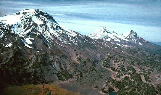
23 mi MountainThree Sisters
26 mi MountainNewberry Volcano
23 mi State parkSmith Rock State Park19 mi Ski areaMt. Bachelor128 runs · 3,233 ft vertical
25 mi Park & preserveNewberry National Volcanic Monument
7 mi MuseumHigh Desert Museum150K visitors a yearThree Sisters: USGS photo by Lyn Topinka, Public domain · Newberry Volcano: USGS photo by Lyn Topinka, Public domain · Smith Rock State Park: Max Schwarz, CC BY-SA 2.5 · Newberry National Volcanic Monument: USGS photo by Lyn Topinka, Public domain · High Desert Museum: Another Believer, CC BY-SA 3.0
2 within 15 miles of the center of Bend
About 5 of every 100 Bend residents are enrolled in college, about the same as Oregon.
76,639 counted in 2010 and 99,178 in 2020; an estimated 107,342 in 2025.
Growth hasn’t slowed: 8.2% since 2020, after 29.4% in the decade before.
U.S. Census 2010 & 2020 counts · Census Bureau estimate, July 1, 2025
28 places in Bend on the National Register of Historic Places.
18 notable people were born in Bend.
City in Oregon, U.S.
Bend is a city in Central Oregon and the seat of government of Deschutes County, Oregon, United States. It is located to the east of the Cascade Range, on the Deschutes River. The site became known by pioneers as a fordable crossing point of the river, where it ran through a bend. An 1870s ranch popularized the name "Farewell Bend," with the post office later distinguishing the area as Bend. It was incorporated as a city in 1905, starting off as a logging town. In 1910, Mirror Pond was created as a dammed river reservoir to provide energy. In 1950, the two major logging companies were consolidated due to depleted timber, causing an economic drop. In later decades, it experienced rapid growt…
From Wikipedia, licensed CC BY-SA 4.0 · facts via Wikidata (CC0)
2 towns share a border with Bend.
| Town | OR rank | Overall | Cost | Safety | Schools | Health |
|---|---|---|---|---|---|---|
| Bend | #21 | B+ | D | C+ | A | A |
| Tetherow | — | — | — | — | — | — |
| Deschutes River Woods | #19 | B+ | C− | — | A | A− |
Deschutes River Woods reports no FBI crime data of its own. Tetherow isn’t graded (fewer than 1,000 residents, or not enough data). Compare Bend with a neighbor →
Short answers, built from the data on this page.
By most measures, yes. Bend grades B+ overall, better than 71% of U.S. towns and #21 of 142 in Oregon. It grades A for health, C+ for safety and A for schools. Cost of living is its weak spot, with a D.
Within Oregon, it does better than 68% of towns.
Yes. Cost of living, which also weighs rents, property taxes and how many households pay 30% or more of their income for housing, grades D.
18 notable people were born here, including Ian Boswell and William A. Niskanen.