
Minor Park, 2009
Rivergrove’s story
55 years in pictures
Census counts: 314 in 1980, 545 in 2020. The archive holds 3 old photos and papers going back to 2004 and 7 maps from 1914 on.
- 1971Rivergrove is settled
Each edition grades its towns against each other only.
A town of 536, settled in 1971.
80% of adults 25 and older hold a bachelor’s degree or more in Rivergrove, against 27% in Oregon’s towns and 29% across U.S. towns. Of the 141 Oregon towns we compare, none has a higher median rent than Rivergrove. Rivergrove has fewer than 1,000 residents, too few for fair grades; the figures below are still real.
In a town this size, neighbors are the best guide. Ask them anything.
Census counts: 314 in 1980, 545 in 2020. The archive holds 3 old photos and papers going back to 2004 and 7 maps from 1914 on.
Museums, parks, gardens and other places to visit around Rivergrove. Close and well known come first.
 11 mi Stadium & arenaModa Center
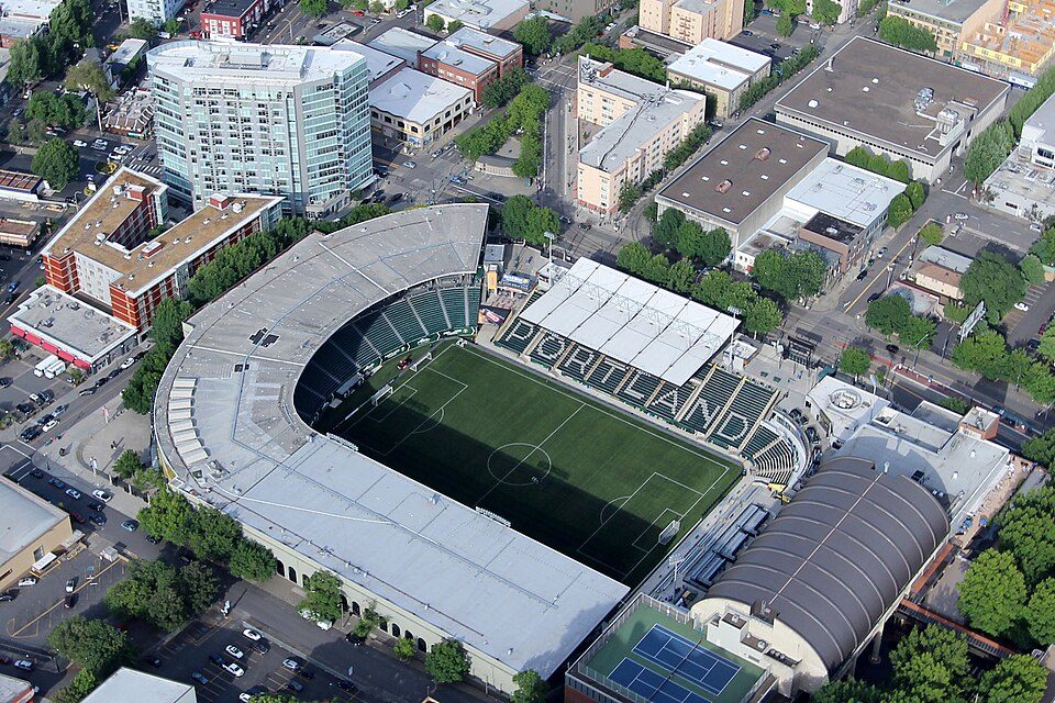 10 mi Stadium & arenaProvidence Park
 33 mi WaterfallMultnomah Falls
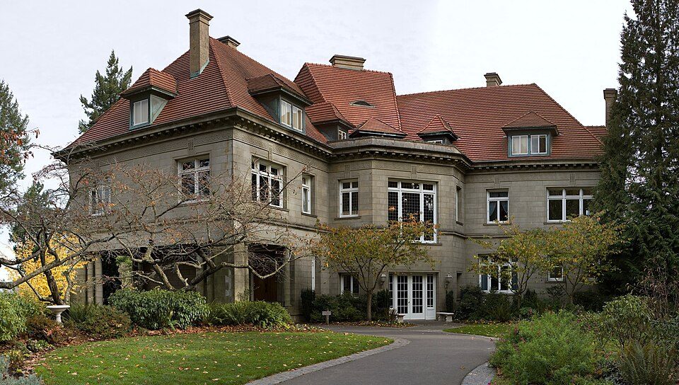 10 mi MuseumPittock Mansion
 11 mi GardenForest Park
 6 mi WaterfallWillamette Falls
Moda Center: Lugnuts, CC BY-SA 3.0 · Providence Park: Pdx.rollingthunder, CC BY-SA 4.0 · Multnomah Falls: John Fowler from Placitas, NM, USA, CC BY 2.0 · Pittock Mansion: PittockBack.jpg: Cacophony derivative work: Tiptoety talk, CC BY-SA 3.0 · Forest Park: EncMstr, CC BY-SA 3.0 · Willamette Falls: The original uploader was Cacophony at English Wikipedia., CC BY-SA 3.0
Who provides power, water and the rest in Rivergrove, and how to reach them.
EPA SDWIS (Oct 9, 2026) · HIFLD + EIA-861 2025 · Census 2020 ZCTAs · NCES 2024–25 · registration: vote.gov, updated Oct 2, 2026.
Ordered by what stands out in Rivergrove.
Rivergrove’s median household income is $213,000, where Oregon’s towns sit at $81,000 and U.S. towns at $80,000. 5.3% of Rivergrove residents live below the poverty line. Since 2013, Rivergrove has lost 32 jobs, to 26 in 2023.
| Rivergrove | Oregon towns | U.S. towns | |
|---|---|---|---|
| Median household income | $213,000 | $81,000 | $80,000 |
| Below the poverty line | 5.3% | 11% | 9.6% |
| Average trip to work | 23 minutes | 23 minutes | 25 minutes |
Census LEHD 2023 · ACS
Expected storm and flood damage is higher than in 78% of U.S. communities. Since 1996, 24 flood insurance claims have been paid out in Rivergrove.
FEMA flood insurance claims · FEMA National Risk Index · OpenFEMA
Rivergrove has mild winters and pleasant summers. Rivergrove’s July high is 81°F.
NOAA U.S. Climate Normals, 1991–2020
7.7% of adults smoke cigarettes in Rivergrove. Rivergrove beats the Oregon average on 13 of 26 CDC measures and trails it on 0. 16% of adults get no exercise outside work in Rivergrove.
| Rivergrove | Oregon towns | U.S. towns | |
|---|---|---|---|
| Frequent mental distress (CDC PLACES) | 14% | 18% | 17% |
| Smoke cigarettes (CDC PLACES) | 7.7% | 13% | 14% |
| Frequent physical distress (CDC PLACES) | 11% | 15% | 14% |
| Get no exercise (CDC PLACES) | 16% | 21% | 25% |
| What stands out | Rivergrove | OR |
|---|---|---|
| Fewer older adults who have lost all their teeth | 5.3% | 12.5% |
| Fewer uninsured adults | 4.3% | 8.5% |
CDC PLACES 2025 · modeled estimates for adults · CMS · HRSA
0.2 miles of trail in 2 parks and preserves. The trail density in Rivergrove is 1.0 miles per square mile.
| Rivergrove | Oregon towns | U.S. towns | |
|---|---|---|---|
| Miles of trail per square mile | 1.0 miles per square mile | 0.8 | 0.4 |
| Conserved land | 4.5% | 4.4% | 4.3% |
| Biggest places to walk | Trails | Acres |
|---|---|---|
| 1. Heritage Park | 0.1 mi | 3 |
| 2. Lloyd Minor Park | — | 1 |
Trails & parks © OpenStreetMap contributors · Conserved land: USGS PAD-US
Zillow Home Value Index · Redfin Data Center
15 within 15 miles of the center of Rivergrove
About 6 of every 100 Rivergrove residents are enrolled in college, about the same as Oregon.
Where Rivergrove’s working residents go each day. Line width shows the share.
Census LEHD 2023
City in Oregon, United States
Rivergrove is a city in Clackamas County, Oregon, United States. A small portion of the city extends into nearby Washington County. Its name is a portmanteau of the Tualatin River, which forms its southern border, and Lake Grove, a community that is now part of Lake Oswego. Interstate 5 forms the western border, with Childs Road serving as the northern border for much of the city. The population was 545 at the 2020 census.
From Wikipedia, licensed CC BY-SA 4.0 · facts via Wikidata (CC0)
Short answers, built from the data on this page.
Rivergrove has fewer than 1,000 residents, too few for fair grades; the figures below are still real.


