Wyoming dates to 1861, and 25% of its homes were built before 1940
More historic than 82% of U.S. towns · #271 of 993 in Ohio. What drives it
20 places in town are on the National Register, among them a historic district with 277 buildings. Below: 1 old photo or paper, maps from 1898 on, and the census since 1880.
Founding year: Wikidata. First post office: 1873.The full story ↓
History grade
What drives Wyoming’s History grade
On its age, its old homes and the National Register, Wyoming is more historic than 82% of U.S. towns, #271 of 993 in Ohio. Its National Register listings hold the grade up; its age pulls it down.
A−
HistoryA character grade: shown, never part of Wyoming’s overall grade.
Ohio towns list about as much on the Register as the country (a typical Ohio town has 2.9 per 10,000 residents, the U.S. 2.4), so Wyoming’s 339 sits above most of its state (98% of Ohio towns have fewer) while its 296 historic buildings outnumber those of 95% of U.S. towns.
How sure. Graded on any two of the three inputs instead, the letter would range from B to A. The pre-1940 share is a Census survey estimate (±6.0 points). Two sources give 1861.
Founding year: Wikidata (other dates in Quick answers). Homes: Census ACS 2020–24. National Register: National Park Service, May 2026 list; each listing counted once (boundary changes and added documentation belong to their listing), and a historic district counts its contributing buildings. How TownRatings grades history →
What stands out about Wyoming’s past
Read from the archive, the National Register and the record. The page puts what stands out first.
Among the earliest European-American settlers in what is now Wyoming was the Pendery family, who arrived in 1805. Wyoming was named after Wyoming County, Pennsylvania, where some settlers had come from. Robert Reily is considered the "Father of Wyoming" with men and women gathering at his home one week prior to the start of the Civil War in 1861, naming the village Wyoming—a Lenape term meaning "large plains." In 1874, Wyoming officially became a village with 600 residents, and in 1951, the village incorporated as a city of over 5,000 persons, implementing the council–manager form of government.
Passages that mention Wyoming, cut from the printed page as they were published.
History of Scranton, Penn. With full outline of the natural advantages, accounts of the Indian tribes, early settlements, Connecticut's claim to the Wyoming Valley, the Trenton decree, down to the present time1891 · page 358Read the page →
Read the text
secretary and treasurer, and Jacob Robinson, William J3reck, 'William W. Monies, and Mr. Sanderson, directors. Work commenced on the grading of this road about ]!^ovember 20, 1866, and cars commeiiced running May 29, 1867, from the depot and the head of Wyoming Avenue, the road being popularly known as the Scranton & Providence Railroad. By June, 1867, the company was running cars with considerable regularity from the Scranton depot of the Delaware, Lackawanna & Western Railroad, to the Providence depot of the
Text read by machine from the scan; it may contain errors.
History of Scranton, Penn. With full outline of the natural advantages, accounts of the Indian tribes, early settlements, Connecticut's claim to the Wyoming Valley, the Trenton decree, down to the present time1891 · page 71Read the page →
Read the text
EARLY SURVEYS ANt) SETTLEMENTS. 71 a blacksmith. Joseph Slocum, the father of Jonathan, and Isaac Tripp came to Wyoming in 1769. Jonathan sold his land in Warwick in February, 1771, and followed his father and father-in-law to Wyoming, where he did "ye duty of a settler" for Ojidirk [OpdykeJ "in ye township called Capouse Meadows.", Jonathan returned to Warwick, but again came on to Wyoming in the spring of 1774. He received from Jonathan Fitch a deed dated November 6, 1775, for a lot in
Text read by machine from the scan; it may contain errors.
Scans and text from the Internet Archive. Books published in 1930 or earlier, which are in the public domain.
Timeline
Wyoming, 1861 to 1902
Woven from the archive, old maps, post office records, the National Register and the people born here.
In 1861, according to Wikidata. Wyoming’s post office opened in 1873, and the census of 1880 counted 840 people here.
How does Wyoming rank for history?
Wyoming is more historic than 82% of U.S. towns, #271 of 993 in Ohio. The History grade combines the town’s founding era, the share of homes built before 1940 and its National Register listings. It’s a character grade, so it isn’t part of the overall grade. How it works.
What is on the National Register in Wyoming?
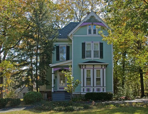
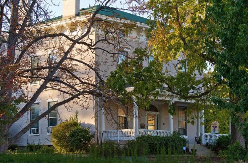
20 listings: 19 buildings, among them the Twin Oaks (listed 1975, the first), and 1 historic district, the Village Historic District, with 277 contributing buildings. 296 historic buildings in all.
How old are the homes in Wyoming?
25% of Wyoming’s homes were built before 1940 (Census estimate, ±6.0 points), against a typical 15% for an Ohio town; the median home was built in 1954.
Founding dates: Wikidata, Wikipedia, the U.S. post office records of Blevins & Helbock (CC0) and the Census. Homes by year built: Census ACS 2020–24. National Register of Historic Places: National Park Service (list of May 22, 2026). Old photos, postcards and papers: Wikimedia Commons, the Library of Congress and other public archives, credited on each item’s page. Maps: U.S. Geological Survey historical topographic maps (via Esri) and Sanborn fire-insurance maps (Library of Congress). History text and census tables: Wikipedia (CC BY-SA 4.0). Places that used to be: USGS Geographic Names Information System (2021).
From the Library of Congress (1), Wikidata (3), the National Register of Historic Places (20), Wikipedia, Wikidata and Wikipedia for famous people, U.S. Geological Survey historical maps, U.S. Census counts (via Wikipedia), the US Post Offices dataset (Blevins & Helbock), the USGS Geographic Names Information System and old county and town histories (Internet Archive). Archive images are copied here with their credits and licenses, shown on each photo’s page. Refreshed monthly.





![secretary and treasurer, and Jacob Robinson, William J3reck, 'William W. Monies, and Mr. Sanderson, directors. Work commenced on the grading of this road about ]!^ovember 20, 1866, and cars commeiiced running May 29, 1867, from the depot and the head of Wyoming Avenue, the road being popularly know…](https://images.townratings.com/story/13433/bk-95bd2f74e6a9aefa-l.jpg)


 Date?


