Waynesville dates to 1796, and 12% of its homes were built before 1940
More historic than 87% of U.S. towns · #200 of 993 in Ohio. What drives it
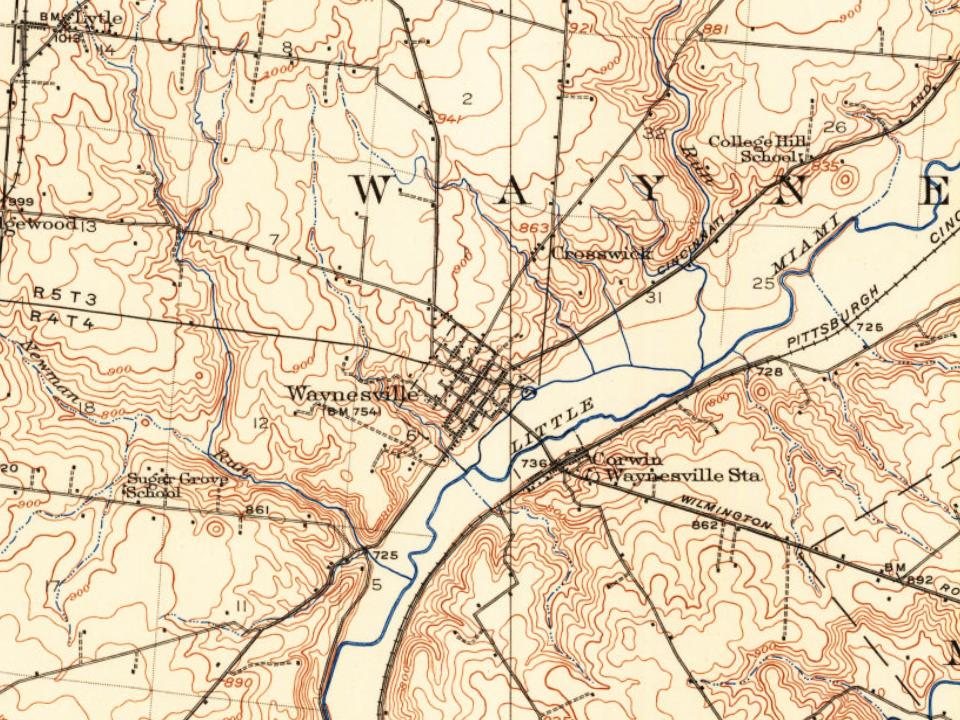
4 places in town are on the National Register, among them two historic districts with 103 buildings between them. Below: 1 old photo or paper, maps from 1895 on, and the census since 1830.
On its age, its old homes and the National Register, Waynesville is more historic than 87% of U.S. towns, #200 of 993 in Ohio. All 3 inputs are above most U.S. towns; its National Register listings ranks highest and its share of homes from before 1940 lowest.
A
HistoryA character grade: shown, never part of Waynesville’s overall grade.
Ohio towns list about as much on the Register as the country (a typical Ohio town has 2.9 per 10,000 residents, the U.S. 2.4), so Waynesville’s 382 sits above most of its state (98% of Ohio towns have fewer) while its 106 historic buildings outnumber those of 90% of U.S. towns.
How sure. Graded on any two of the three inputs instead, the letter would range from B+ to A. The pre-1940 share is a Census survey estimate (±3.9 points). Two sources give 1796.
Founding year: Wikipedia (other dates in Quick answers). Homes: Census ACS 2020–24. National Register: National Park Service, May 2026 list; each listing counted once (boundary changes and added documentation belong to their listing), and a historic district counts its contributing buildings. How TownRatings grades history →
What stands out about Waynesville’s past
Read from the archive, the National Register and the record. The page puts what stands out first.
Waynesville was laid out in 1796. It was named in honor of General “Mad” Anthony Wayne. Waynesville was originally built up chiefly by Quakers. A post office has been in operation at Waynesville since 1804.
Passages that mention Waynesville, cut from the printed page as they were published.
The History of Warren County, Ohio1882 · page 570Read the page →
Read the text
The citizens took an early interest in education, and, as neighborly were settled, a log schoolhouse was built with narrow openings at the ei< sufficient to receive a single 8x10 glass. Among the first school-teachers w Rowland Richards, who taught in a log schoolhouse in Waynesville in 18( Joel Wright, who taught at Abijah O’Neall’s, in east Wayne Township, in 1 years 1802, 1804 and 1805; Elizabeth Wright, in 1808, and, between that a the year 1820, Joel and Allen Wright, who both taught in Waynesville; fn 1820 to 1824, Thomas Ricket taught in Waynesville: he was followed
Text read by machine from the scan; it may contain errors.
The first Friends’ meeting house, built for that purpose, at Waynesville, was on the S. W. corner of Fourth and High streets, at or very near the site of the present meeting house of Orthodox Friends. It was probably erected after Miami m..m. was established — say in 1803 or 1804 and was a log structure. I am inclined to the opinion that it was succeeded by a larger and better one of the same material
Text read by machine from the scan; it may contain errors.
Joel Wright lived in Waynesville many years before his removal to Springboro, where he spent the closing years of his life. While living in Waynesville he was occupied in teaching school, surveying and buying and selling land. A brief notice of some of the real estate transactions to v/hich he was a party may be of interest as showing the difference in prices of land at the beginning and the close of the nineteenth
Text read by machine from the scan; it may contain errors.
Creek meeting house, on the n. w. side of the creek, about 7 miles nearly east of Waynesville, 10, 24, 1805. Merged later in the established m. f. w. of the same name.
Text read by machine from the scan; it may contain errors.
Scans and text from the Internet Archive. Books published in 1930 or earlier, which are in the public domain.
Timeline
Waynesville, 1796 to 1913
Woven from the archive, old maps, post office records, the National Register and the people born here.
Nothing in the archives for these yearsWeddings on Main Street, storms, parades, school pictures, the old store. If it’s in your family album, it belongs here.
Fire insurance maps drew every building, what it was made of and what it was used for, so insurers could price the risk of fire. Pick a year, then a sheet.
In 1796, according to Wikipedia’s history of the town. Waynesville’s post office opened in 1804, and the census of 1830 counted 439 people here.
How does Waynesville rank for history?
Waynesville is more historic than 87% of U.S. towns, #200 of 993 in Ohio. The History grade combines the town’s founding era, the share of homes built before 1940 and its National Register listings. It’s a character grade, so it isn’t part of the overall grade. How it works.
What is on the National Register in Waynesville?
4 listings: 2 buildings, among them the John Satterthwaite House (listed 1988, the first), and 2 historic districts, the Waynesville Main Street Historic District and the Miami Monthly Meeting Historic District, with 103 contributing buildings. 106 historic buildings in all.
How old are the homes in Waynesville?
12% of Waynesville’s homes were built before 1940 (Census estimate, ±3.9 points), against a typical 15% for an Ohio town; the median home was built in 1979.
Founding dates: Wikidata, Wikipedia, the U.S. post office records of Blevins & Helbock (CC0) and the Census. Homes by year built: Census ACS 2020–24. National Register of Historic Places: National Park Service (list of May 22, 2026). Old photos, postcards and papers: Wikimedia Commons, the Library of Congress and other public archives, credited on each item’s page. Maps: U.S. Geological Survey historical topographic maps (via Esri) and Sanborn fire-insurance maps (Library of Congress). History text and census tables: Wikipedia (CC BY-SA 4.0). Places that used to be: USGS Geographic Names Information System (2021).
From Wikimedia Commons (4), the Library of Congress (1), Wikidata (1), the National Register of Historic Places (4), Wikipedia, Wikidata and Wikipedia for famous people, U.S. Geological Survey historical maps, U.S. Census counts (via Wikipedia), the US Post Offices dataset (Blevins & Helbock), the USGS Geographic Names Information System, Sanborn fire insurance maps (Library of Congress) and old county and town histories (Internet Archive). Archive images are copied here with their credits and licenses, shown on each photo’s page. Refreshed monthly.




 2011
 2009
 2005
 2004


