On its age, its old homes and the National Register, Struthers is more historic than 64% of U.S. towns, #492 of 993 in Ohio. Its share of homes from before 1940 holds the grade up; its National Register listings pull it down.
B
HistoryA character grade: shown, never part of Struthers’ overall grade.
Ohio towns list about as much on the Register as the country (a typical Ohio town has 2.9 per 10,000 residents, the U.S. 2.4), so Struthers’ 0.0 sits below most of its state (23% of Ohio towns have fewer) while its 0 listings outnumber those of 23% of U.S. towns.
How sure. Graded on two of the three inputs, so a change in either one moves the letter more than it would with three. The pre-1940 share is a Census survey estimate (±5.1 points).
Founding year: our sources. Homes: Census ACS 2020–24. National Register: National Park Service, May 2026 list; each listing counted once (boundary changes and added documentation belong to their listing), and a historic district counts its contributing buildings. How TownRatings grades history →
What stands out about Struthers’ past
Read from the archive, the National Register and the record. The page puts what stands out first.
Nothing in the archives for these yearsWeddings on Main Street, storms, parades, school pictures, the old store. If it’s in your family album, it belongs here.
John Struthers, from Washington County, Pennsylvania, purchased 400 acres (1.6 km2) of Poland Township land in 1798 and gave it the name Marbletown. John Struthers owned this land until the War of 1812 came around when he and his family suffered financial ruin. The land was dormant until 1865 when it was purchased by Thomas Struthers. Thomas bought this land to honor his father and he was instrumental in bringing industry and railroads to the town. Eventually, the town name was changed to Struthers by popular vote.
In 1943, a Jehovah's Witness was fined by the city for distributing religious pamphlets door-to-door. The U.S. Supreme Court ruled that this was a violation of the First Amendment in Martin v. Struthers.
Passages that mention Struthers, cut from the printed page as they were published.
20th century history of Youngstown and Mahoning County, Ohio1907 · page 247Read the page →
Read the text
of Poland, in Mahoning County. On the same stream, about three-fourths of a mile from its mouth, and on the fann on which was furnace of the Struthers Furnace Company, in the town of Struthers, another furnace was built, in 1806, by Robert Montgomery and John Struthers. This furnace was called Montgomery. Thomas Struthers writes :
Text read by machine from the scan; it may contain errors.
Twentieth century history of Youngstown and Mahoning County, Ohio1907 · page 246Read the page →
Read the text
of Poland, in Mahoning County. On the same stream, about three-fourths of a mile from its mouth, and on llie farm on which was furnace of the Struthers Furnace Company, in the town of Struthers, another furnace was built, in 1806, by Robert Montgomery anil John Struthers. This furnace was called Montgomery. Thomas Struthers writes:
Text read by machine from the scan; it may contain errors.
Twentieth century history of Youngstown and Mahoning County, Ohio1907 · page 223Read the page →
Read the text
John Struthers, from whom this village is named, arrived October 19, 1799, from Washington county, Pennsylvania, and bought land on which a large part of the village of Struthers is now situated, which he converted into a farm. He was accompanied by his family, and in 1801 became the father of a son, Ebenczer, who was the first white male child
Text read by machine from the scan; it may contain errors.
20th century history of Youngstown and Mahoning County, Ohio1907 · page 687Read the page →
Read the text
management of the different farms, employing skilled labor to operate them. He continued to reside in Poland township until 1900, when he removed with his family to Struthers, taking possession of a commodious and comfortable residence there. :\Ir. Smith was identified with a number of Struthers' enterprises, being vice-president and a director of the
Text read by machine from the scan; it may contain errors.
Scans and text from the Internet Archive. Books published in 1930 or earlier, which are in the public domain.
Timeline
Struthers, 1868 to 1960
Woven from the archive, old maps, post office records, the National Register and the people born here.
Struthers is more historic than 64% of U.S. towns, #492 of 993 in Ohio. The History grade combines the town’s founding era, the share of homes built before 1940 and its National Register listings. It’s a character grade, so it isn’t part of the overall grade. How it works.
How old are the homes in Struthers?
39% of Struthers’ homes were built before 1940 (Census estimate, ±5.1 points), against a typical 15% for an Ohio town; the median home was built in 1950.
Founding dates: Wikidata, Wikipedia, the U.S. post office records of Blevins & Helbock (CC0) and the Census. Homes by year built: Census ACS 2020–24. National Register of Historic Places: National Park Service (list of May 22, 2026). Old photos, postcards and papers: Wikimedia Commons, the Library of Congress and other public archives, credited on each item’s page. Maps: U.S. Geological Survey historical topographic maps (via Esri) and Sanborn fire-insurance maps (Library of Congress). History text and census tables: Wikipedia (CC BY-SA 4.0). Places that used to be: USGS Geographic Names Information System (2021).
From Wikimedia Commons (12), Wikipedia, Wikidata and Wikipedia for famous people, U.S. Geological Survey historical maps, U.S. Census counts (via Wikipedia), the US Post Offices dataset (Blevins & Helbock), the USGS Geographic Names Information System and old county and town histories (Internet Archive). Archive images are copied here with their credits and licenses, shown on each photo’s page. Refreshed monthly.


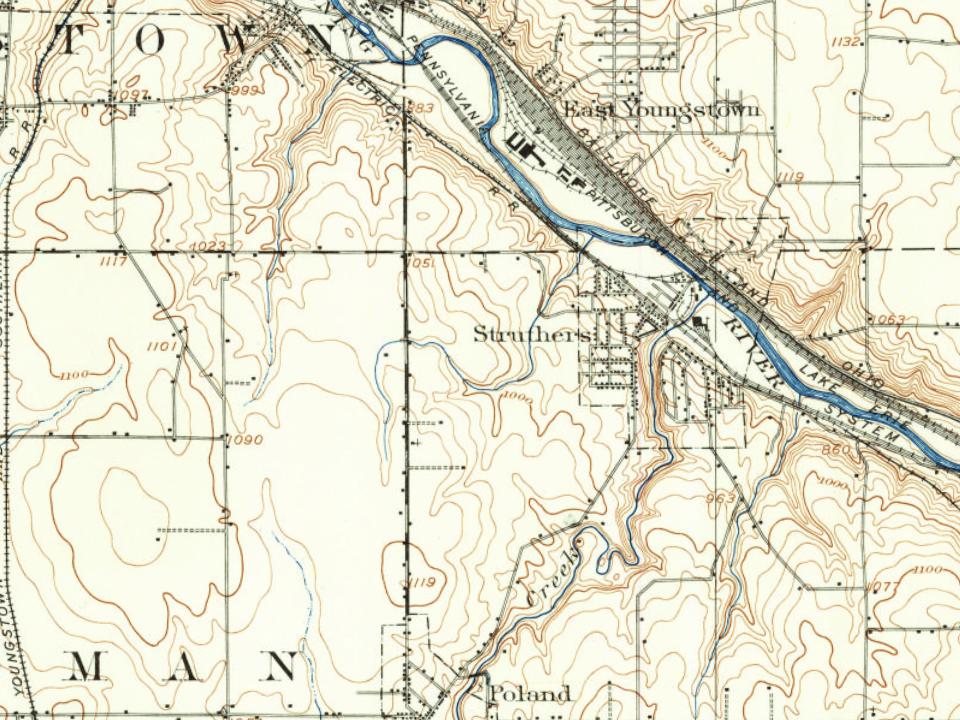


 1899
 1899
 1899
 1899
 1899
 1899
 1899
 1899
 1899
 1899
 1899
 1899