Wikipedia doesn’t have a history of Lowellville yet. The photos, dates and memories neighbors add here are how it gets written.
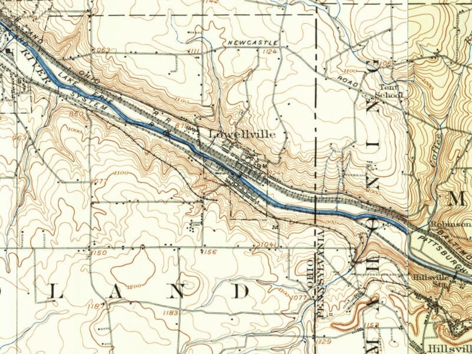
Lowellville is a village in eastern Mahoning County, Ohio, United States, along the Mahoning River. The population was 996 at the 2020 census. Located about 8 miles (13 km) southeast of Youngstown, it is part of the Youngstown–Warren metropolitan area.
Its first post office opened in 1838. Between the 2010 and 2020 censuses its population fell from 1,155 to 996 (-14%).
Intro from Wikipedia. Population: U.S. Census Bureau.
People over time
Lowellville, census by census
Peaked at 2,550 in 1930; 996 people lived here in 2020.
18 censuses, 1850–2020.
U.S. Census Bureau decennial counts, from the census table on Lowellville’s Wikipedia page.
From the old history books
What they wrote about Lowellville in 1907
Passages that mention Lowellville, cut from the printed page as they were published.
20th century history of Youngstown and Mahoning County, Ohio1907 · page 222Read the page →
Read the text
Holy Rosary Mission Church. — The erection of a Catholic church at Lowellville was first proposed about 1867, some twenty Catholic families having taken up their residence in the place, owing to the building of the Ashtabula & Pittsburg Railroad, and also the starting of a furnace. The foundation was begun in 1868, but owing to the failure of the above
Text read by machine from the scan; it may contain errors.
Twentieth century history of Youngstown and Mahoning County, Ohio1907 · page 222Read the page →
Read the text
Holy Rosary Mission Church. — The erection of a Catholic church at Lowellville was first proposed about 1867, some twenty Catholic families having taken up their residence in the place, owing to the building of the Ashtabula & Pittsburg Railroad, and also the starting of a furnace. The foundation was begun in 1868, but owing to the failure of the above
Text read by machine from the scan; it may contain errors.
20th century history of Youngstown and Mahoning County, Ohio1907 · page 795Read the page →
Read the text
his profession claims his time to such an extent that he has never considered himself an active politician, although he served two years as mayor of Lowellville, from 1900 to 1902. He has always been interested in the general welfare of Lowellville, and willingly exerts his influence to advance public measures which promise benefit to all concerned. He belongs
Text read by machine from the scan; it may contain errors.
Twentieth century history of Youngstown and Mahoning County, Ohio1907 · page 800Read the page →
Read the text
Freeh has met with great prosperity all his fellow citizens know and they unite in saying that it is deserved. There are few men in the town of Lowellville who are lietter known. It has always been his custom to look personally after his business. He owns his own slaughter house in Poland Center, and makes a practice of killing ami dressing his own meat. His
Text read by machine from the scan; it may contain errors.
Scans and text from the Internet Archive. Books published in 1930 or earlier, which are in the public domain.
Timeline
Lowellville, 1838 to 1930
Woven from the archive, old maps, post office records, the National Register and the people born here.
Founding dates: Wikidata, Wikipedia, the U.S. post office records of Blevins & Helbock (CC0) and the Census. Homes by year built: Census ACS 2020–24. National Register of Historic Places: National Park Service (list of May 22, 2026). Old photos, postcards and papers: Wikimedia Commons, the Library of Congress and other public archives, credited on each item’s page. Maps: U.S. Geological Survey historical topographic maps (via Esri) and Sanborn fire-insurance maps (Library of Congress). History text and census tables: Wikipedia (CC BY-SA 4.0). Places that used to be: USGS Geographic Names Information System (2021). How TownRatings grades history →
From Wikimedia Commons (5), Wikidata (1), the National Register of Historic Places (1), Wikidata and Wikipedia for famous people, U.S. Geological Survey historical maps, U.S. Census counts (via Wikipedia), the US Post Offices dataset (Blevins & Helbock), the USGS Geographic Names Information System and old county and town histories (Internet Archive). Archive images are copied here with their credits and licenses, shown on each photo’s page. Refreshed monthly.


 2023
 2015
 2011
 2006
 2004