More historic than 96% of U.S. towns · #45 of 993 in Ohio. What drives it
With 32% of its homes built before 1940 and 4 historic districts holding 231 contributing buildings. Below: 6 old photos and papers, maps from 1886 on, the census since 1830, and every listing on the Register.
The Sandusky post office opened in 1806, the earliest record of the town by name. Wikidata gives 1818. Two smaller post offices, Venice (1827) and Cedar Point (1907), opened inside today’s city and later closed.
First census: 593 in 18302020 census: 25,095220 years
How historic is Sandusky?
A+
More historic than 96% of U.S. towns, on its age, its old homes and the National Register.
Founding year: the first Sandusky post office (Blevins & Helbock, CC0). Wikidata: 1818.The full story ↓
History grade
What drives Sandusky’s History grade
On its age, its old homes and the National Register, Sandusky is more historic than 96% of U.S. towns, #45 of 993 in Ohio. All 3 inputs are above most U.S. towns; its National Register listings ranks highest and its age lowest.
A+
HistoryA character grade: shown, never part of Sandusky’s overall grade.
Ohio towns list about as much on the Register as the country (a typical Ohio town has 2.9 per 10,000 residents, the U.S. 2.4), so Sandusky’s 93.9 sits above most of its state (92% of Ohio towns have fewer) while its 231 historic buildings outnumber those of 94% of U.S. towns.
How sure. Graded on any two of the three inputs instead, the letter would range from A to A+. The pre-1940 share is a Census survey estimate (±3.4 points). The founding year is the first post office, not a stated founding date; Wikidata’s 1818 falls in the same era, so the grade doesn’t depend on which one is used.
Founding year: the first post office (other dates in Quick answers). Homes: Census ACS 2020–24. National Register: National Park Service, May 2026 list; each listing counted once (boundary changes and added documentation belong to their listing), and a historic district counts its contributing buildings. How TownRatings grades history →
What stands out about Sandusky’s past
Read from the archive, the National Register and the record. The page puts what stands out first.
National Park Service, National Register of Historic Places. Photos from Wikimedia Commons, credited on each place’s page.
Places that used to be
Lost post offices, old corners, places now gone and burying grounds
Sandusky’s post office has been open since 1806. Two other post offices opened and closed inside today’s town.
Sandusky
1806–today
Venice
1827–1963
Cedar Point
1907–1915
18001910today
Hamlets and corners on the map
Anchor Mobile Home ParkBayshore Estates Mobile Home ParkBaywater EstatesCedar PointHoopers Mobile Home ParkLions ParkMacArthur ParkVeniceWestview Estates
Gone or out of use
Calvary Baptist TabernaclechurchCedar Point Post Officepost officeEvangel Assembly ChurchchurchPorter Chapel African Methodist Episcopal ChurchchurchSaint Johns Protestant Episcopal ChurchchurchVenice Post Officepost officeWest Market Schoolschool
4cemeteries and burying grounds inside Sandusky
CalvaryCholeraSaint JosephsSaint Mary's
US Post Offices dataset (Blevins & Helbock, CC0). Places and cemeteries from the USGS Geographic Names Information System (2021).
This area was a center of trading and fortifications since the 18th century: the English, French, and Americans had trading posts and forts built on both the north and south sides of Sandusky Bay.
George Croghan was one of the more prominent men who operated in this area in the 18th century. A federal fur trade factory was established in 1808 but was lost at the beginning of the War of 1812.
Passages that mention Sandusky, cut from the printed page as they were published.
History of Sandusky County, Ohio1882 · page 97Read the page →
Read the text
dusky on the west side of the river. The location of the county-seat became a question of hot contest between Croghansville and the new town of Sandusky. After much discussion, commissioners to settle the question of difference were appointed by the General Assembly of the State. On viewing the ground and hearing the argu-
Text read by machine from the scan; it may contain errors.
An historical account of the expedition against Sandusky under Col. William Crawford in 17821873 · page 11Read the page →
Read the text
Without waiting the result of Clark's campaign, an expedition had been, in the meantime, concerted against Sandusky — Upper Sandusky, as it was sometimes called, to distinguish it from Lower Sandusky, a Wyandot town where Fremont, the county town of Sandusky county, Ohio, now stands — by Colonel Gibson, who had succeeded Brodhead in temporary command at Fort Pitt — so eager were the oppressed people of the border
Text read by machine from the scan; it may contain errors.
History of Sandusky County, Ohio1882 · page 166Read the page →
Read the text
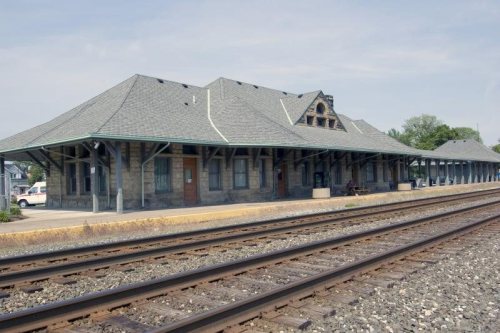
the most feasible route to intersect the Mad River & Lake Erie at Bellevue, or at such other ])oint as the directors should choose, and thence to Lower Sandusky (Fremont), and the power was also given to this company to construct the railroad, or a branch of it, from Elyria to Sandusky City, in Erie county, and from thence to
Text read by machine from the scan; it may contain errors.
Commemorative biographical record of the counties of Sandusky and Ottawa, Ohio, containing biographical sketches of prominent1896Read the page →
Read the text
til 1838 when he came to Ohio, locating at Plasterbed, Ottawa county, where he was engaged for a short time. He then bought and occupied a farm in Sandusky county, and at length settled in Sandusky City, where he lived over thirty years, serving as engineer and conductor for different railroad companies. In 1864 he
Text read by machine from the scan; it may contain errors.
Scans and text from the Internet Archive. Books published in 1930 or earlier, which are in the public domain.
Timeline
Sandusky, 1806 to 1963
Woven from the archive, old maps, post office records, the National Register and the people born here.
Nothing in the archives for these yearsWeddings on Main Street, storms, parades, school pictures, the old store. If it’s in your family album, it belongs here.
Every edition of the U.S. Geological Survey’s map of Sandusky. Tap a year, or press play to watch the town change.
1904Sandusky sheet · 1:62,500
U.S. Geological Survey historical topographic maps (public domain), via Esri’s collection of the scans. The red ring marks the center of Sandusky.
Every building
Sandusky, building by building, 1886–1905
Fire insurance maps drew every building, what it was made of and what it was used for, so insurers could price the risk of fire. Pick a year, then a sheet.
The Sandusky post office opened in 1806, the earliest record of the town by name (U.S. post office records). Wikidata gives 1818.
How does Sandusky rank for history?
Sandusky is more historic than 96% of U.S. towns, #45 of 993 in Ohio. The History grade combines the town’s founding era, the share of homes built before 1940 and its National Register listings. It’s a character grade, so it isn’t part of the overall grade. How it works.
What is on the National Register in Sandusky?
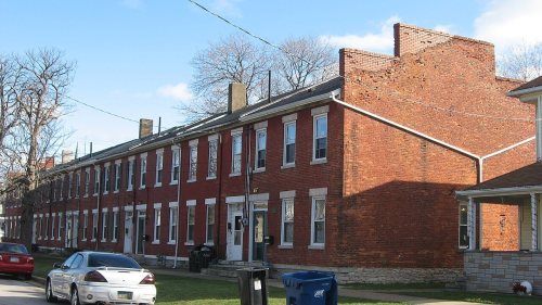
115 listings: 105 buildings, among them the Mad River Block (listed 1974, the first), 4 historic districts with 105 contributing buildings, 1 site, 4 structures, and 1 object. 231 historic buildings in all.
How old are the homes in Sandusky?
32% of Sandusky’s homes were built before 1940 (Census estimate, ±3.4 points), against a typical 15% for an Ohio town; the median home was built in 1955.
Founding dates: Wikidata, Wikipedia, the U.S. post office records of Blevins & Helbock (CC0) and the Census. Homes by year built: Census ACS 2020–24. National Register of Historic Places: National Park Service (list of May 22, 2026). Old photos, postcards and papers: Wikimedia Commons, the Library of Congress and other public archives, credited on each item’s page. Maps: U.S. Geological Survey historical topographic maps (via Esri) and Sanborn fire-insurance maps (Library of Congress). History text and census tables: Wikipedia (CC BY-SA 4.0). Places that used to be: USGS Geographic Names Information System (2021).
From the Library of Congress (6), the National Register of Historic Places (115), Wikipedia, U.S. Geological Survey historical maps, U.S. Census counts (via Wikipedia), the US Post Offices dataset (Blevins & Helbock), the USGS Geographic Names Information System, Sanborn fire insurance maps (Library of Congress) and old county and town histories (Internet Archive). Archive images are copied here with their credits and licenses, shown on each photo’s page. Refreshed monthly.






![the most feasible route to intersect the Mad River & Lake Erie at Bellevue, or at such other ])oint as the directors should choose, and thence to Lower Sandusky (Fremont), and the power was also given to this company to construct the railroad, or a branch of it, from Elyria to Sandusky City, in Eri…](https://images.townratings.com/story/13634/bk-fdcd8affd0bb3858-l.jpg)


 1905
 1905
 1905
 1905


