New Albany dates to 1837, and 1 of its places is on the National Register
More historic than 46% of U.S. towns · #697 of 993 in Ohio. What drives it
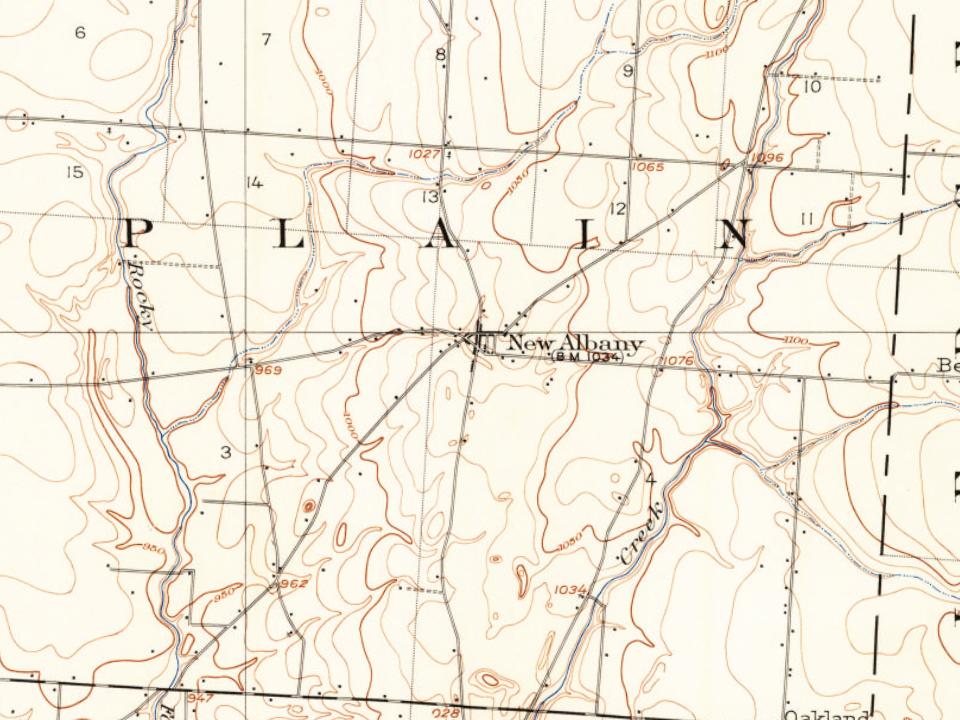
Most of New Albany was built recently: 2% of its homes predate 1940 and the median home dates from 2005. Its Register listing is the George and Christina Ealy House. Below: maps from 1902 on and the census since 1850.
Founding year: Wikidata. First post office: 1838.The full story ↓
History grade
What drives New Albany’s History grade
On its age, its old homes and the National Register, New Albany is more historic than 46% of U.S. towns, #697 of 993 in Ohio. Its age holds the grade up; its share of homes from before 1940 pulls it down.
B−
HistoryA character grade: shown, never part of New Albany’s overall grade.
Ohio towns list about as much on the Register as the country (a typical Ohio town has 2.9 per 10,000 residents, the U.S. 2.4), so New Albany’s 0.9 sits near the middle of its state (49% of Ohio towns have fewer) while its 1 listings outnumber those of 51% of U.S. towns.
How sure. Graded on any two of the three inputs instead, the letter would range from C to B+. The pre-1940 share (±2.2 points) is firm at this size. Two sources give 1837.
Founding year: Wikidata (other dates in Quick answers). Homes: Census ACS 2020–24. National Register: National Park Service, May 2026 list; each listing counted once (boundary changes and added documentation belong to their listing), and a historic district counts its contributing buildings. How TownRatings grades history →
What stands out about New Albany’s past
Read from the archive, the National Register and the record. The page puts what stands out first.
The land of New Albany was founded in the center of Plain Township in 1837 by Nobel Landon and William Yantis. The land was split into lots measuring 50 ft (15 m) by 100 ft (30 m) and sold to new settlers. One theory about the name is that some of the original settlers migrated from the Albany, New York, area. Albany, Ohio was laid out in 1832, prior to the founding of New Albany. During its history, the community has also been known by the name of Hope.
In 1856, New Albany was incorporated with a population of 50, and S. Ogden was elected as the first mayor. Initially known as The Wilkins Lumber Mill, the New Albany Mill opened in 1881. The first female mayor of New Albany, Mrs. Edward Babbitt was elected in 1922.
Passages that mention New Albany, cut from the printed page as they were published.
History of Franklin County [Ohio]1858 · page 222Read the page →
Read the text
a good brick meeting house, erected about 1837 or '38, in the northern part of the township, called "Plain Chapel," and a good frame meeting house in the town of New Albany, erected about 1847 or '48. The United Brethren are also tolerably numerous. They have a brick church near the center of the township, erected about the year 1836 or 37. The Albrites, German, have a good wooden church building about one mile
Text read by machine from the scan; it may contain errors.
History of Franklin County [Ohio]1858 · page 223Read the page →
Read the text
In May, 1837, Noble Landon and William Yantis laid out the town of New Albany, not as partners, but one owned the land on one side of the main street, and the other on the opposite side, and they had it all platted together, but each one held or disposed of his own lots at his pleasure. It is now a thriving village, and quite an advantage to the country around. The town is incorporated, and in April, 1856, they held their
Text read by machine from the scan; it may contain errors.
Centennial history of Columbus and Franklin County, Ohio1909 · page 422Read the page →
Read the text
In May, 1837, Messrs. Noble Landon and William Yantis laid out the present town of New Albany. They were not partners, however. They were owners of adjoining farms which lay on either side of what was to constitute Main street. They had two tracts laid out and platted as one, but each owned, held and controlled the sale of lots on his side. of the street. It grew into a thriving village; was a good country business point, and still continues to be a pleasant and hospitable village.
Text read by machine from the scan; it may contain errors.
Centennial history of Columbus and Franklin County, Ohio1909 · page 669Read the page →
Read the text
It was in 1898 that Mr. Stephens became interested in suburban railway lines. He organized and aided in building the Columbus, New Albany & Johnstown Railroad and was elected secretary and general manager of the company, which position he still fills. The road was built in 1901 and constitutes one of the trade arteries of the city. He is also the president of the Columbus, Urbana & Western Railroad Company and second vice president of the Columbus Savings & Trust Company.
Text read by machine from the scan; it may contain errors.
Scans and text from the Internet Archive. Books published in 1930 or earlier, which are in the public domain.
Timeline
New Albany, 1837 to 2020
Woven from the archive, old maps, post office records, the National Register and the people born here.
In 1837, according to Wikidata. New Albany’s post office opened in 1838, and the census of 1850 counted 168 people here.
How does New Albany rank for history?
New Albany is more historic than 46% of U.S. towns, #697 of 993 in Ohio. The History grade combines the town’s founding era, the share of homes built before 1940 and its National Register listings. It’s a character grade, so it isn’t part of the overall grade. How it works.
What is on the National Register in New Albany?
One place: the George and Christina Ealy House (listed 2008).
How old are the homes in New Albany?
2% of New Albany’s homes were built before 1940 (Census estimate, ±2.2 points), against a typical 15% for an Ohio town; the median home was built in 2005.
Founding dates: Wikidata, Wikipedia, the U.S. post office records of Blevins & Helbock (CC0) and the Census. Homes by year built: Census ACS 2020–24. National Register of Historic Places: National Park Service (list of May 22, 2026). Old photos, postcards and papers: Wikimedia Commons, the Library of Congress and other public archives, credited on each item’s page. Maps: U.S. Geological Survey historical topographic maps (via Esri) and Sanborn fire-insurance maps (Library of Congress). History text and census tables: Wikipedia (CC BY-SA 4.0). Places that used to be: USGS Geographic Names Information System (2021).
From Wikimedia Commons (5), Wikidata (1), the National Register of Historic Places (1), Wikipedia, Wikidata and Wikipedia for famous people, U.S. Geological Survey historical maps, U.S. Census counts (via Wikipedia), the US Post Offices dataset (Blevins & Helbock), the USGS Geographic Names Information System and old county and town histories (Internet Archive). Archive images are copied here with their credits and licenses, shown on each photo’s page. Refreshed monthly.



 2022
 2022
 2022
 2022
 2019