More historic than 23% of U.S. towns · #892 of 993 in Ohio. What drives it
Most of Commercial Point was built recently: 6% of its homes predate 1940 and the median home dates from 2006. Below: maps from 1923 on and the census since 1870.
The Commercial Point post office opened in 1872, the earliest record of the town by name. Another post office, Becketts Store (1846), opened inside today’s town and later closed.
First census: 154 in 18702020 census: 3,078154 years
How historic is Commercial Point?
C−
More historic than 23% of U.S. towns, on its age, its old homes and the National Register.
Founding year: the first Commercial Point post office (Blevins & Helbock, CC0).The full story ↓
History grade
What drives Commercial Point’s History grade
On its age, its old homes and the National Register, Commercial Point is more historic than 23% of U.S. towns, #892 of 993 in Ohio. Its age holds the grade up; its National Register listings pull it down.
C−
HistoryA character grade: shown, never part of Commercial Point’s overall grade.
Ohio towns list about as much on the Register as the country (a typical Ohio town has 2.9 per 10,000 residents, the U.S. 2.4), so Commercial Point’s 0.0 sits below most of its state (23% of Ohio towns have fewer) while its 0 listings outnumber those of 23% of U.S. towns.
How sure. Graded on any two of the three inputs instead, the letter would range from C− to C. The pre-1940 share is a Census survey estimate (±3.9 points). The founding year is the first post office, not a stated founding date.
Founding year: the first post office (other dates in Quick answers). Homes: Census ACS 2020–24. National Register: National Park Service, May 2026 list; each listing counted once (boundary changes and added documentation belong to their listing), and a historic district counts its contributing buildings. How TownRatings grades history →
What stands out about Commercial Point’s past
Read from the archive, the National Register and the record. The page puts what stands out first.
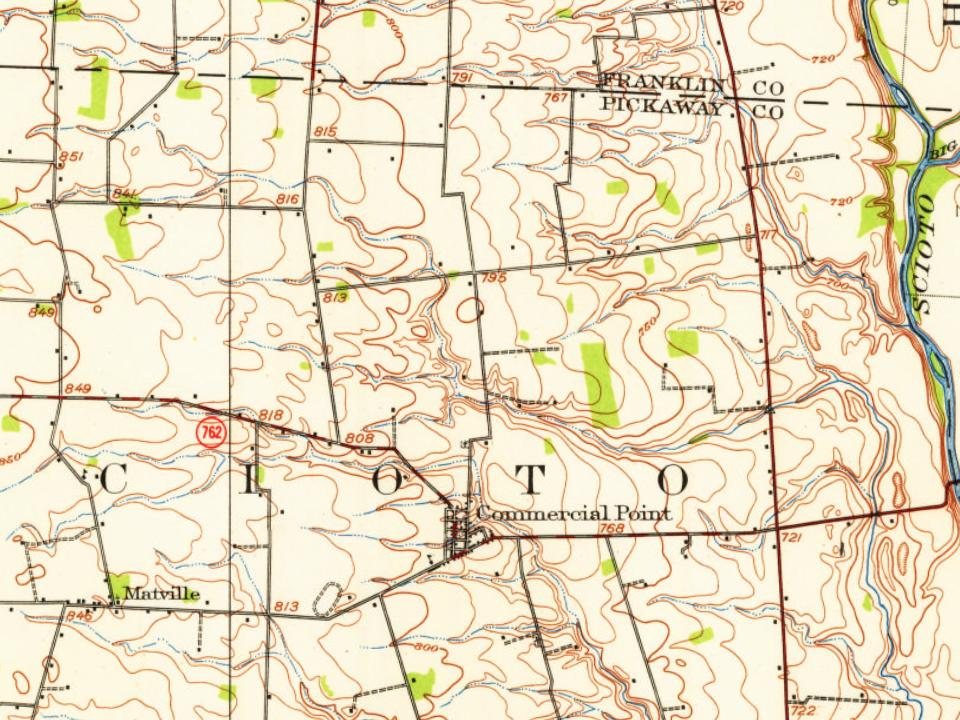
Every edition of the U.S. Geological Survey’s map of Commercial Point. Tap a year, or press play to watch the town change.
1923West Columbus sheet · 1:62,500
U.S. Geological Survey historical topographic maps (public domain), via Esri’s collection of the scans. The red ring marks the center of Commercial Point.
Wiley H. Beckett came from eastern Virginia in 1829 and settled on a 238-acre tract west of the present Commercial Point. In 1841 he laid out a community called Genoa. James H. Burnley, also from Virginia, arrived in the area in 1832 and laid out a similar community east of Genoa called Rome. As the two towns grew larger, Rome became the western half, and Genoa the eastern half, of a new single town. When Genoa was incorporated in 1851, Rome was merged into the new village. The first store was established in 1844 by Wiley H. Beckett, and the post office was originally named Beckett's Store. The name of the village was changed in 1872 to Commercial Point.
Wiley H. Beckett, who came from Eastern Virginia in 1829 and settled on a 238-acre tract of land, to the west of the present village of Commercial Point, laid out in 1841 a parcel of land in the northeastern part of his tract for the purpose of forming a town which he named ‘‘Genoa.” Two years later James H.
Text read by machine from the scan; it may contain errors.
HISTORY OF PICKAWAY COUNTY, OHIO AND REPERESENTATIVE CITIZENS1906 · page 178Read the page →
Read the text
Wiley H. Beckett, who came from Eastern Virginia in 1829 and settled on a 238-acre tract of land, to the west of the present village of Commercial Point, laid out in 1841 a parcel of land in the northeastern part of his tract for the purpose of forming a town which he named “Genoa.” Two years kater James H.
Text read by machine from the scan; it may contain errors.
French, Shell. Kingery and S. M. Seeds, all of whom were located at what is now the village of Commercial Point. Dr. T. \V. Jones practiced in this township many years; he lived on a farm now occupied hv James M. Borror, which he operated. The town has two physicians at the present time: Dr. S. C. Helmick, who has been engaged in practice here for many
Text read by machine from the scan; it may contain errors.
HISTORY OF PICKAWAY COUNTY, OHIO AND REPERESENTATIVE CITIZENS1906 · page 173Read the page →
Read the text
Commercial Point M. E. Church.—The first Methodist Episcopal Church in Scioto township was organized between 1829 and 1834, at which time a log church was built and called Point Pleasant Church. Religious services were held in the township by Revs. Austin and Philips as early as 1829 and by Rev. John McKinley, a local preacher. In 1854 a small
Text read by machine from the scan; it may contain errors.
Scans and text from the Internet Archive. Books published in 1930 or earlier, which are in the public domain.
Timeline
Commercial Point, 1846 to 1923
Woven from the archive, old maps, post office records, the National Register and the people born here.
The Commercial Point post office opened in 1872, the earliest record of the town by name (U.S. post office records).
How does Commercial Point rank for history?
Commercial Point is more historic than 23% of U.S. towns, #892 of 993 in Ohio. The History grade combines the town’s founding era, the share of homes built before 1940 and its National Register listings. It’s a character grade, so it isn’t part of the overall grade. How it works.
How old are the homes in Commercial Point?
6% of Commercial Point’s homes were built before 1940 (Census estimate, ±3.9 points), against a typical 15% for an Ohio town; the median home was built in 2006.
Founding dates: Wikidata, Wikipedia, the U.S. post office records of Blevins & Helbock (CC0) and the Census. Homes by year built: Census ACS 2020–24. National Register of Historic Places: National Park Service (list of May 22, 2026). Old photos, postcards and papers: Wikimedia Commons, the Library of Congress and other public archives, credited on each item’s page. Maps: U.S. Geological Survey historical topographic maps (via Esri) and Sanborn fire-insurance maps (Library of Congress). History text and census tables: Wikipedia (CC BY-SA 4.0). Places that used to be: USGS Geographic Names Information System (2021).
From Wikimedia Commons (6), Wikipedia, U.S. Geological Survey historical maps, U.S. Census counts (via Wikipedia), the US Post Offices dataset (Blevins & Helbock), the USGS Geographic Names Information System and old county and town histories (Internet Archive). Archive images are copied here with their credits and licenses, shown on each photo’s page. Refreshed monthly.



 2012
 2012
 2012
 2008
 2008
 2004


