Guest, Sign inJoin

Post to College Corner

We’ll email a one-tap link to publish your post. No password, and nothing is public until you click it.
Already a member? Sign in
–Not graded
History · College Corner

College Corner dates to 1811, and 58% of its homes were built before 1940

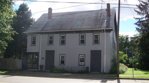
Its Register listing is the Howe Tavern. Below: 3 old photos and papers, maps from 1960 on, and the census since 1900.

1811founded
1on the National Register
58%homes built before 1940
3old photos & papers
From College Corner’s archive · credits on each photo
Quick answers

How College Corner began

When was College Corner founded?

1811

College Corner dates its founding to 1811 (Wikipedia’s history). The census first counted it in 1900.

First census: 378 in 19002020 census: 387215 years
Founding year: Wikipedia.The full story ↓

What stands out about College Corner’s past

Read from the archive, the National Register and the record. The page puts what stands out first.

★ What stands out · Help out

Start College Corner’s collection

The first neighbors to add old photos shape how College Corner’s history is told.

Decades since 1900 with photos
00s10s20s30s40s50s60s70s80s90s
1 of 10 decades. The empty ones are waiting for someone’s album.
The story

How College Corner came to be

From Wikipedia’s history of College Corner.

Read it all →

College Corner was settled in 1811 and takes its name from its position in the northwestern corner of the "College Township", the survey township designated the previous year by the Ohio General Assembly as the site of the state college that became Miami University. This survey township was later organized as a civil township, Oxford Township. College Corner was laid out in 1837.

Text from Wikipedia, licensed CC BY-SA 4.0.

Timeline

College Corner, 1811 to 1960

Woven from the archive, old maps, post office records, the National Register and the people born here.

  1. 19th century
  2. 1811
    FoundingCollege Corner is established
  3. 1875In the archiveCombination Atlas Map of Butler County Ohio, 1875: Compiled, Drawn and Published from Per…
  4. 20th century
  5. 1914In the archiveButler County Atlas and Pictorial Review: Including Surveys, Geological Reports, Township…
  6. 1960On the mapFirst mapped by the U.S. Geological Survey
From the old history books

What they wrote about College Corner, 1881–1915

Passages that mention College Corner, cut from the printed page as they were published.

College Corner is an incorporated village. Oxford township, Butler county, is a college township, owned by Miami University. The first settlement at the village was in the northwest corner of that township, hence the name.
History of Preble County Ohio1915 · page 245Read the page →
Read the text

College Corner is an incorporated village. Oxford township, Butler county, is a college township, owned by Miami University. The first settlement at the village was in the northwest corner of that township, hence the name.

Text read by machine from the scan; it may contain errors.
The villages of the township, which are scarcely more than “wide places in the pike,” are two in number, Fair Haven, in the north, and Morning Sun, in the center of the township. The town of College Corner, which is located in the extreme northwest comer of Oxford township, Butler county, and which…
History of Preble County Ohio1915 · page 241Read the page →
Read the text

The villages of the township, which are scarcely more than “wide places in the pike,” are two in number, Fair Haven, in the north, and Morning Sun, in the center of the township. The town of College Corner, which is located in the extreme northwest comer of Oxford township, Butler county, and which takes its name from its location (Oxford township belonging to Miami University), has wandered across the state line into Indiana and has also crossed the county line into Israel township. But it must be reckoned with the Butler county towns; Israel township can not properly claim it.

Text read by machine from the scan; it may contain errors.
church at that place. Mr. McCracken labored for twenty years, during which time the congregation gradually increased, and although another swarm left the hive to form the Unity church at College Corner in the winter of 1849-50, and a very considerable number emigrated to the west, the church was as…
History of Preble County Ohio1881 · page 234Read the page →
Read the text

church at that place. Mr. McCracken labored for twenty years, during which time the congregation gradually increased, and although another swarm left the hive to form the Unity church at College Corner in the winter of 1849-50, and a very considerable number emigrated to the west, the church was as strong, numerically, at the close of the pastor’s labors, as it was at the beginning. He died September 10, 1859, loved and lamented

Text read by machine from the scan; it may contain errors.

Scans and text from the Internet Archive. Books published in 1930 or earlier, which are in the public domain.

By decade

College Corner, decade by decade

2 decades in the archive, from the 1870s to the 1910s. Scroll each row; tap a photo for its story.

On the map

College Corner on the map, 1960 to 1992

Every edition of the U.S. Geological Survey’s map of College Corner. Tap a year, or press play to watch the town change.

College Corner on the 1960 USGS mapCollege Corner on the 1974 USGS mapCollege Corner on the 1992 USGS map1960College Corner sheet · 1:24,000

U.S. Geological Survey historical topographic maps (public domain), via Esri’s collection of the scans. The red ring marks the center of College Corner.

Then & now

Stand where they stood

No then-and-now pairs yet. Take a photo from the same spot as an old one and they appear here side by side.

West-college-corner-indiana-from-above
Retake this viewWest-college-corner-indiana-from-above

Find the spot, match the angle, and add your photo. It becomes the first then-and-now pair on College Corner’s page.

Retake this view · +15
On the National Register

1 historic place in College Corner

The country’s official list of buildings and places worth saving.

place listed
1
National Historic Landmarks
0
none yet
historic buildings protected
1
each building in a district counts
first listed
1976
Howe Tavern
Buildings

National Park Service, National Register of Historic Places. Photos from Wikimedia Commons, credited on each place’s page.

People over time

College Corner, census by census

01002003004005001900192019401960198020002020Peak: 468

Between 348 and 468 people in every census since 1900.

13 censuses, 1900–2020.

U.S. Census Bureau decennial counts, from the census table on College Corner’s Wikipedia page.

Famous people

Famous people close to College Corner

Nobody well known was born in College Corner itself, so here are the best known from just nearby.

See all →
Stories next door

History across the town line

Each neighbor’s History grade, on the same three inputs.

Questions about College Corner’s history

What year was College Corner founded?

In 1811, according to Wikipedia’s history of the town. the census of 1900 counted 378 people here.

What is on the National Register in College Corner?

One place: the Howe Tavern (listed 1976).

Memory lane

What the archives can’t tell you, neighbors can.

Town Square →
Start a conversation
Sources

Where this page comes from

Founding dates: Wikidata, Wikipedia, the U.S. post office records of Blevins & Helbock (CC0) and the Census. Homes by year built: Census ACS 2020–24. National Register of Historic Places: National Park Service (list of May 22, 2026). Old photos, postcards and papers: Wikimedia Commons, the Library of Congress and other public archives, credited on each item’s page. Maps: U.S. Geological Survey historical topographic maps (via Esri) and Sanborn fire-insurance maps (Library of Congress). History text and census tables: Wikipedia (CC BY-SA 4.0). Places that used to be: USGS Geographic Names Information System (2021). How TownRatings grades history →

From Wikimedia Commons (7), the National Register of Historic Places (1), Wikipedia, U.S. Geological Survey historical maps, U.S. Census counts (via Wikipedia), the USGS Geographic Names Information System and old county and town histories (Internet Archive). Archive images are copied here with their credits and licenses, shown on each photo’s page. Refreshed monthly.