Amherst’s post office opened in 1830, and 11% of its homes were built before 1940
More historic than 70% of U.S. towns · #426 of 993 in Ohio. What drives it
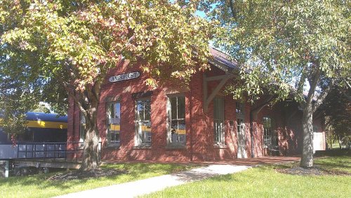
Its Register listings are the Amherst Town Hall, the Old Amherst Freight Depot and the Central School. Below: 11 old photos and papers, maps from 1901 on, and the census since 1880.
Founding year: the first Amherst post office (Blevins & Helbock, CC0).The full story ↓
History grade
What drives Amherst’s History grade
On its age, its old homes and the National Register, Amherst is more historic than 70% of U.S. towns, #426 of 993 in Ohio. Its age holds the grade up; its share of homes from before 1940 pulls it down.
B+
HistoryA character grade: shown, never part of Amherst’s overall grade.
Ohio towns list about as much on the Register as the country (a typical Ohio town has 2.9 per 10,000 residents, the U.S. 2.4), so Amherst’s 2.3 sits near the middle of its state (53% of Ohio towns have fewer) while its 3 listings outnumber those of 65% of U.S. towns.
How sure. Graded on any two of the three inputs instead, the letter would range from B to B+. The pre-1940 share (±2.7 points) is firm at this size. The founding year is the first post office, not a stated founding date.
Founding year: the first post office (other dates in Quick answers). Homes: Census ACS 2020–24. National Register: National Park Service, May 2026 list; each listing counted once (boundary changes and added documentation belong to their listing), and a historic district counts its contributing buildings. How TownRatings grades history →
What stands out about Amherst’s past
Read from the archive, the National Register and the record. The page puts what stands out first.
The original village, which eventually became known as Amherst, was established/founded by pioneer settler Jacob Shupe (who came to this area in 1811; however, what would become the specific “downtown” area was settled by Josiah Harris in 1818), although the original tiny village was first known only as "Amherst Corners" in the early-1830s. When the village-plat was officially recorded in 1836, it was simply named the "town plat of Amherst", but became "Amherstville" circa-1839, and was later changed to "North Amherst", until finally again simply 'Amherst' in 1909. (The original 1820s postal-name of the village's first post-office was "Plato"; and the village's post-office retained that postal-name into the 1840s, even after the local-government name of the village officially became 'Amherstville' by 1840.)
Passages that mention Amherst, cut from the printed page as they were published.
A standard history of Lorain county, Ohio1916Read the page →
Read the text
Village Founded Early in the history of Amherst Township, the nucleus for a village was formed upon the north ridge, about a mile northwest of the center of the township. This settlement, — the embryo Village of North Amherst,— was known for many years as "the corner." Judge Josiah Harris had quite a tract of land here, and he laid out a i)ortion of it in lots, and founded the Village of Amlierstville. Through the decades, lieginning with the years 1830, 1840 and 1850, the growtii of the village was
Text read by machine from the scan; it may contain errors.
History of Lorain County Ohio with Illustrations and Biographical Sketches of Some of Its Prominent Men and Pionners1879 · page 343Read the page →
Read the text
is he appreciated in the community, and from time to time that appreciation has been shown by placing him in several of the elective offices of the township of Amherst. He has successively held the offices of township assessor, township clerk, justice of the peace, and was the first mayor of the incorporated village of North Amherst. He was postmaster of Amherst during President Johnson’s administration. Politi-
Text read by machine from the scan; it may contain errors.
History of Lorain County, Ohio1879 · page 214Read the page →
Read the text
October, 1818, when Brownhelm was detached and incorporated as an independent township. Russia was detached in June, 1825, leaving the territory now embraced in the township of Amherst and Black River forming one township. These two towns continued as one until January 13, 1830, when by a special act of the legislature, they were divided.
Text read by machine from the scan; it may contain errors.
History of Lorain County Ohio with Illustrations and Biographical Sketches of Some of Its Prominent Men and Pionners1879 · page 210Read the page →
Read the text
October, 1818, when Brownhelm was detached and incorporated as an independent township. Russia was detached in June, 1825, leaving the territory now embraced in the township of Amherst and Black River forming one township. These two towns continued as one until January 12, 1830, when by a special act of the legislature, they were divided.
Text read by machine from the scan; it may contain errors.
Scans and text from the Internet Archive. Books published in 1930 or earlier, which are in the public domain.
By decade
Amherst, decade by decade
3 decades in the archive, from the 1890s to the 1910s. Scroll each row; tap a photo for its story.
Nothing in the archives for these yearsWeddings on Main Street, storms, parades, school pictures, the old store. If it’s in your family album, it belongs here.
Fire insurance maps drew every building, what it was made of and what it was used for, so insurers could price the risk of fire. Pick a year, then a sheet.
The Amherst post office opened in 1830, the earliest record of the town by name (U.S. post office records).
How does Amherst rank for history?
Amherst is more historic than 70% of U.S. towns, #426 of 993 in Ohio. The History grade combines the town’s founding era, the share of homes built before 1940 and its National Register listings. It’s a character grade, so it isn’t part of the overall grade. How it works.
What is on the National Register in Amherst?
Three places: the Amherst Town Hall (listed 1975), the Old Amherst Freight Depot (1978) and the Central School (1987).
How old are the homes in Amherst?
11% of Amherst’s homes were built before 1940 (Census estimate, ±2.7 points), against a typical 15% for an Ohio town; the median home was built in 1971.
Founding dates: Wikidata, Wikipedia, the U.S. post office records of Blevins & Helbock (CC0) and the Census. Homes by year built: Census ACS 2020–24. National Register of Historic Places: National Park Service (list of May 22, 2026). Old photos, postcards and papers: Wikimedia Commons, the Library of Congress and other public archives, credited on each item’s page. Maps: U.S. Geological Survey historical topographic maps (via Esri) and Sanborn fire-insurance maps (Library of Congress). History text and census tables: Wikipedia (CC BY-SA 4.0). Places that used to be: USGS Geographic Names Information System (2021).
From Wikimedia Commons (11), Wikidata (1), the National Register of Historic Places (3), Wikipedia, Wikidata and Wikipedia for famous people, U.S. Geological Survey historical maps, U.S. Census counts (via Wikipedia), the US Post Offices dataset (Blevins & Helbock), the USGS Geographic Names Information System, Sanborn fire insurance maps (Library of Congress) and old county and town histories (Internet Archive). Archive images are copied here with their credits and licenses, shown on each photo’s page. Refreshed monthly.


 1892
 1908
 1909
 1909
 1909
 1909
 1909
 1909