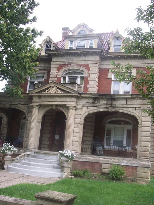
Lorain dates to 1807, and 20% of its homes were built before 1940
More historic than 90% of U.S. towns · #154 of 993 in Ohio. What drives it
18 places in town are on the National Register, among them a historic district with 101 buildings. Below: 27 old photos and papers, maps from 1888 on, and the census since 1880.
Founding year: Wikidata. First post office: 1812.The full story ↓
History grade
What drives Lorain’s History grade
On its age, its old homes and the National Register, Lorain is more historic than 90% of U.S. towns, #154 of 993 in Ohio. All 3 inputs are above most U.S. towns; its National Register listings ranks highest and its share of homes from before 1940 lowest.
A
HistoryA character grade: shown, never part of Lorain’s overall grade.
Ohio towns list about as much on the Register as the country (a typical Ohio town has 2.9 per 10,000 residents, the U.S. 2.4), so Lorain’s 18.2 sits above most of its state (80% of Ohio towns have fewer) while its 119 historic buildings outnumber those of 90% of U.S. towns.
NoteThe founding year comes from Wikidata alone; no second source gives 1807.
How sure. Graded on any two of the three inputs instead, the letter would range from A− to A. The pre-1940 share (±1.7 points) is firm at this size.
Founding year: Wikidata (other dates in Quick answers). Homes: Census ACS 2020–24. National Register: National Park Service, May 2026 list; each listing counted once (boundary changes and added documentation belong to their listing), and a historic district counts its contributing buildings. How TownRatings grades history →
What stands out about Lorain’s past
Read from the archive, the National Register and the record. The page puts what stands out first.
Nothing in the archives for these yearsWeddings on Main Street, storms, parades, school pictures, the old store. If it’s in your family album, it belongs here.
According to local government records, the city began as an unincorporated village established before 1834 as “Black River Village”, and was renamed in 1837 as "Charleston." According to 19th-century historians, the new name was rejected by its own citizens, who continued to use Black River Village. The village was incorporated as Lorain in 1874 and became a city in 1896. The first mayor was Conrad Reid, who took office on April 6, 1874. The municipal boundaries incorporated most of the former Black River Township judicial boundaries, and portions of the Sheffield Township, Amherst Township, and Brownhelm Township judicial borders.
Passages that mention Lorain, cut from the printed page as they were published.
A standard history of Lorain county, Ohio1916Read the page →
Read the text
Elyki.v, First Iv.mlkoau Center Before the coming of the railroads many roads had been opened in Lorain County away from the lake shore, especially between Wellington, 01)erlin, Klyria and Lorain, and in 1850 commenced the new era. ' Li tluit year tiie Junction Railroad, now tlie Lake Shore and I\liclugaii iSouthern, was completed, l)y way of Elyi-ia and Amheiist, looping southward through the county several miles from Lake Erie and Lorain. It was not until 1866 that the line to Toledo, by way of Oberlin and
Text read by machine from the scan; it may contain errors.
Commemorative biographical record of the counties of Huron and Lorain, Ohio1894 · page 1209Read the page →
Read the text
geon in the Lakeside Hospital, Cleveland, in which capacity he served for nearly two years. In November, 1892, he came to Lorain, and since his location here has built up quite an extensive practice. Before practicing medicine the Doctor was engaged for eight years as a pharmaceutist, in North Amherst, Cleveland and Lorain,
Text read by machine from the scan; it may contain errors.
A standard history of Lorain county, Ohio1916Read the page →
Read the text
were built a few years ago. This farm and tiie farms where the Ilecock brothers first settled are now of great value. The Hiram Burrell farm is covered with railroad tracks and three high-level bridges connect it with the City of Lorain. Mr. and Mrs. Arnoki Burrell lived in Sheffield when they first came, but removed to Elyria Township. They always attended the Sheffield Churcli. ^Ir. Burrell was a nephew of the Burrell l)rothers. When the ehurcii moved into their new building in 1852 all the families were
Text read by machine from the scan; it may contain errors.
Commemorative biographical record of the counties of Huron and Lorain, Ohio1894 · page 699Read the page →
Read the text
but after a short time turned his back — literally, not figuratively — upon the college, with his face and footsteps toward the town of Lorain. Here he again took up newspaper work, ultimately establishing the Lorain Times, which, after conducting it successfully some six years, he sold out. He then sought employment in
Text read by machine from the scan; it may contain errors.
Scans and text from the Internet Archive. Books published in 1930 or earlier, which are in the public domain.
Timeline
Lorain, 1807 to 1936
Woven from the archive, old maps, post office records, the National Register and the people born here.
Every edition of the U.S. Geological Survey’s map of Lorain. Tap a year, or press play to watch the town change.
1901Oberlin sheet · 1:62,500
U.S. Geological Survey historical topographic maps (public domain), via Esri’s collection of the scans. The red ring marks the center of Lorain.
Every building
Lorain, building by building, 1888–1918
Fire insurance maps drew every building, what it was made of and what it was used for, so insurers could price the risk of fire. Pick a year, then a sheet.
In 1807, according to Wikidata. Lorain’s post office opened in 1812, and the census of 1880 counted 1,595 people here.
How does Lorain rank for history?
Lorain is more historic than 90% of U.S. towns, #154 of 993 in Ohio. The History grade combines the town’s founding era, the share of homes built before 1940 and its National Register listings. It’s a character grade, so it isn’t part of the overall grade. How it works.
What is on the National Register in Lorain?
18 listings: 17 buildings, among them the William Seher House (listed 1976, the first), and 1 historic district, the Broadway Historic District, with 101 contributing buildings. 119 historic buildings in all.
How old are the homes in Lorain?
20% of Lorain’s homes were built before 1940 (Census estimate, ±1.7 points), against a typical 15% for an Ohio town; the median home was built in 1961.
Founding dates: Wikidata, Wikipedia, the U.S. post office records of Blevins & Helbock (CC0) and the Census. Homes by year built: Census ACS 2020–24. National Register of Historic Places: National Park Service (list of May 22, 2026). Old photos, postcards and papers: Wikimedia Commons, the Library of Congress and other public archives, credited on each item’s page. Maps: U.S. Geological Survey historical topographic maps (via Esri) and Sanborn fire-insurance maps (Library of Congress). History text and census tables: Wikipedia (CC BY-SA 4.0). Places that used to be: USGS Geographic Names Information System (2021).
From Wikimedia Commons (24), the Library of Congress (3), Wikidata (3), the National Register of Historic Places (18), Wikipedia, Wikidata and Wikipedia for famous people, U.S. Geological Survey historical maps, U.S. Census counts (via Wikipedia), the US Post Offices dataset (Blevins & Helbock), the USGS Geographic Names Information System, Sanborn fire insurance maps (Library of Congress) and old county and town histories (Internet Archive). Archive images are copied here with their credits and licenses, shown on each photo’s page. Refreshed monthly.


 1890
 1900
 1900
 1907
 1907
 1907
 1907
 1907
 1907
 1908
 1908
 1908
 1908
 1908
 1908
 1908
 1908
 1908
 1908
 1908
 1908
 1908
 1908
 c. 1908
 c. 1908
 1924
 1924