Warsaw dates to 1804, and 36% of its homes were built before 1940
More historic than 93% of U.S. towns · #198 of 758 in New York. What drives it
5 places in town are on the National Register, among them a historic district with 24 buildings. Below: 11 old photos and papers, maps from 1886 on, and the census since 1820.
Founding year: Wikidata. First post office: 1811.The full story ↓
History grade
What drives Warsaw’s History grade
On its age, its old homes and the National Register, Warsaw is more historic than 93% of U.S. towns, #198 of 758 in New York. All 3 inputs are above most U.S. towns; its share of homes from before 1940 ranks highest and its age lowest.
A
HistoryA character grade: shown, never part of Warsaw’s overall grade.
New York towns list more on the Register than most of the country (a typical New York town has 12.3 per 10,000 residents, the U.S. 2.4), so Warsaw’s 54.8 sits above most of its state (69% of New York towns have fewer) while its 29 historic buildings outnumber those of 81% of U.S. towns.
How sure. Graded on any two of the three inputs instead, the letter would range from A− to A. The pre-1940 share is a Census survey estimate (±8.7 points). Two sources give 1804.
Founding year: Wikidata (other dates in Quick answers). Homes: Census ACS 2020–24. National Register: National Park Service, May 2026 list; each listing counted once (boundary changes and added documentation belong to their listing), and a historic district counts its contributing buildings. How TownRatings grades history →
What stands out about Warsaw’s past
Read from the archive, the National Register and the record. The page puts what stands out first.
Lost post offices, old corners, places now gone and burying grounds
Warsaw’s post office has been open since 1811. Two other post offices opened and closed inside today’s town.
Warsaw
1811–today
South Warsaw
1850–1860
Oatka
1891–1895
18101920today
Hamlets and corners on the map
MartinsvilleMcGuires Mobile Home ParkOatkaSouth WarsawThompsons CrossingWest Perry Center
Gone or out of use
Casey's AirportairportFree Methodist ChurchchurchSchool Number 1schoolSisters of Saint Francis ConventchurchWarsaw Academyschool
5cemeteries and burying grounds inside Warsaw
HatchImmanuel United MethodistSaint MichaelsSharp DistrictWarsaw
US Post Offices dataset (Blevins & Helbock, CC0). Places and cemeteries from the USGS Geographic Names Information System (2021).
Every building
Warsaw, building by building, 1886–1919
Fire insurance maps drew every building, what it was made of and what it was used for, so insurers could price the risk of fire. Pick a year, then a sheet.
The Town of Warsaw was founded in 1803 from the Town of Batavia (in Genesee County). In 1812, part of Warsaw was used to form the new town of Town of Middlebury. Again in 1814, Warsaw was reduced to form the Town of Gainesville.
Passages that mention Warsaw, cut from the printed page as they were published.
History of the town of Warsaw, New York, from its first settlement to the present time1869 · page 102Read the page →
Read the text
to LeRoy. The following is a copy of a notice posted along the route: " Notice is hereby given that Books will be open to receive subscriptions to the Capital Stock of the Warsaw and LeRoy Railroad Company, at the Inn kept by Wm. Bingham in the village of Warsaw, on Monday, the 30th day of March next, at 12 o'clock at noon, and at Butler's Mansion House, in the village of Wyoming, on the 31st day of March next, at 12
Text read by machine from the scan; it may contain errors.
History of the town of Warsaw, New York, from its first settlement to the present time1869 · page 191Read the page →
Read the text
Hannah Stearns, John Brown, Wm. Brown, Miriam Brown, Levi Kice, Hannah Pice, Jeremiah Truesdell, Elijah Hammond, Phoda Peed, Joanna Beardsley. A Baptist church having been formed in Middlebury, then a part of Warsaw, this church was called the " Second Baptist Church of Warsaw." After the town of Middlebury had been formed into a separate town, this church was called the " Eirst Baptist
Text read by machine from the scan; it may contain errors.
Scans and text from the Internet Archive. Books published in 1930 or earlier, which are in the public domain.
Timeline
Warsaw, 1804 to 1967
Woven from the archive, old maps, post office records, the National Register and the people born here.
Nothing in the archives for these yearsWeddings on Main Street, storms, parades, school pictures, the old store. If it’s in your family album, it belongs here.
In 1804, according to Wikidata. Warsaw’s post office opened in 1811, and the census of 1820 counted 1,658 people here.
How does Warsaw rank for history?
Warsaw is more historic than 93% of U.S. towns, #198 of 758 in New York. The History grade combines the town’s founding era, the share of homes built before 1940 and its National Register listings. It’s a character grade, so it isn’t part of the overall grade. How it works.
What is on the National Register in Warsaw?
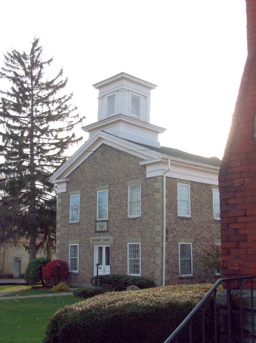
5 listings: 4 buildings, among them the Warsaw Academy (listed 1980, the first), and 1 historic district, the Monument Circle Historic District, with 24 contributing buildings. 29 historic buildings in all.
How old are the homes in Warsaw?
36% of Warsaw’s homes were built before 1940 (Census estimate, ±8.7 points), against a typical 27% for a New York town; the median home was built in 1964.
Founding dates: Wikidata, Wikipedia, the U.S. post office records of Blevins & Helbock (CC0) and the Census. Homes by year built: Census ACS 2020–24. National Register of Historic Places: National Park Service (list of May 22, 2026). Old photos, postcards and papers: Wikimedia Commons, the Library of Congress and other public archives, credited on each item’s page. Maps: U.S. Geological Survey historical topographic maps (via Esri) and Sanborn fire-insurance maps (Library of Congress). History text and census tables: Wikipedia (CC BY-SA 4.0). Places that used to be: USGS Geographic Names Information System (2021).
From Wikimedia Commons (2), the Library of Congress (10), the National Register of Historic Places (5), Wikipedia, Wikidata and Wikipedia for famous people, U.S. Geological Survey historical maps, U.S. Census counts (via Wikipedia), the US Post Offices dataset (Blevins & Helbock), the USGS Geographic Names Information System, Sanborn fire insurance maps (Library of Congress) and old county and town histories (Internet Archive). Archive images are copied here with their credits and licenses, shown on each photo’s page. Refreshed monthly.




 1875
 1875
 1905
 1905
 1905
 1905
 1905
 1905
 2008


