Ticonderoga dates to 1804, and 36% of its homes were built before 1940
More historic than 95% of U.S. towns · #160 of 758 in New York. What drives it
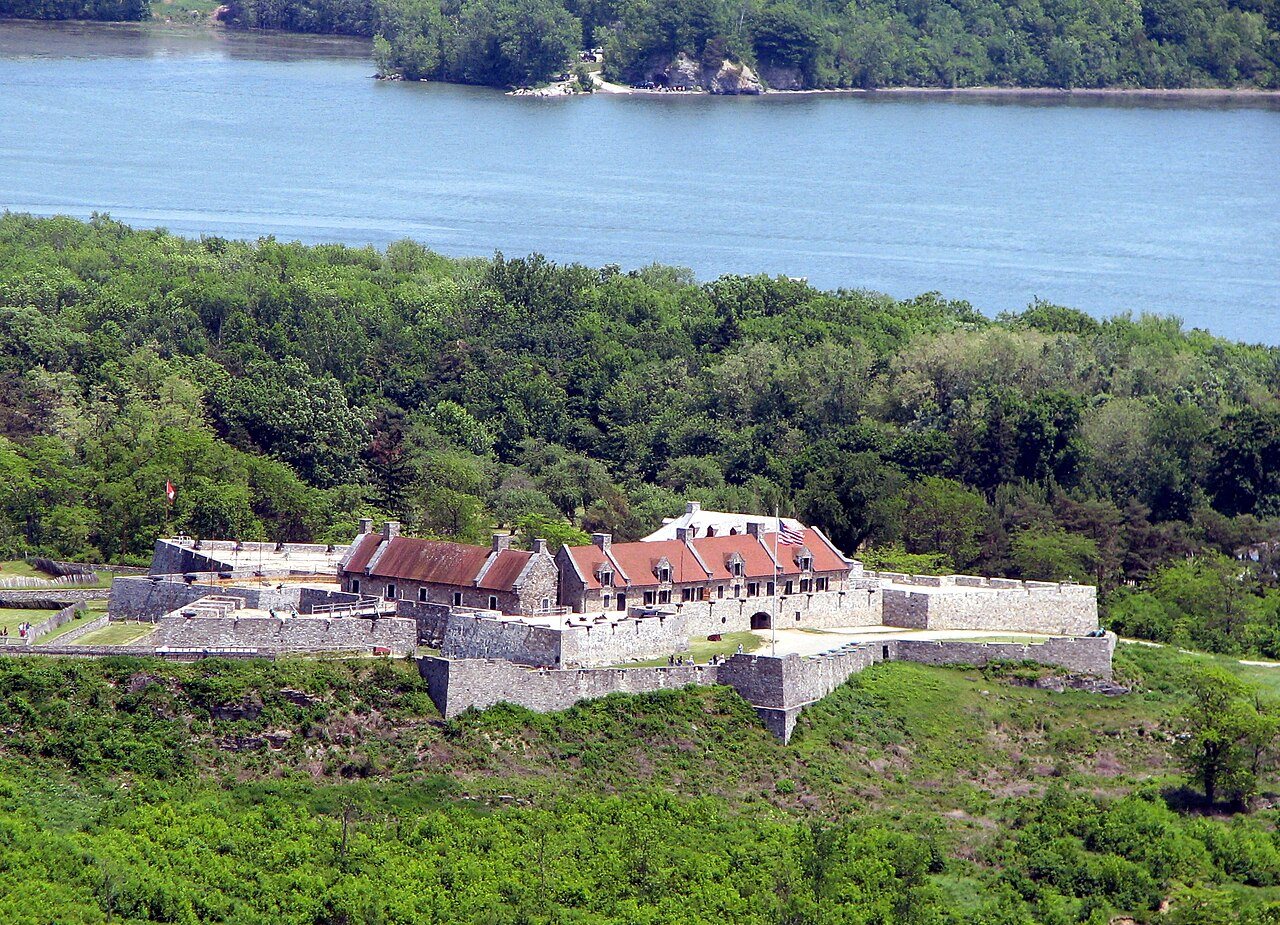
22 places in town are on the National Register, among them the Fort Ticonderoga, a National Historic Landmark, and three historic districts with 39 buildings between them. Below: 5 old photos and papers, maps from 1884 on, and the census since 1820.
Founding year: Wikidata. First post office: 1816.The full story ↓
History grade
What drives Ticonderoga’s History grade
On its age, its old homes and the National Register, Ticonderoga is more historic than 95% of U.S. towns, #160 of 758 in New York. All 3 inputs are above most U.S. towns; its share of homes from before 1940 ranks highest and its age lowest.
A
HistoryA character grade: shown, never part of Ticonderoga’s overall grade.
New York towns list more on the Register than most of the country (a typical New York town has 12.3 per 10,000 residents, the U.S. 2.4), so Ticonderoga’s 123 sits above most of its state (78% of New York towns have fewer) while its 58 historic buildings outnumber those of 86% of U.S. towns.
How sure. Graded on any two of the three inputs instead, the letter would still be A. The pre-1940 share is a Census survey estimate (±6.5 points). Two sources give 1804.
Founding year: Wikidata (other dates in Quick answers). Homes: Census ACS 2020–24. National Register: National Park Service, May 2026 list; each listing counted once (boundary changes and added documentation belong to their listing), and a historic district counts its contributing buildings. How TownRatings grades history →
What stands out about Ticonderoga’s past
Read from the archive, the National Register and the record. The page puts what stands out first.
In the 17th century, French explorers such as Samuel de Champlain encountered the area.
The town was on the direct route, utilizing rivers and two long lakes, between New York City to the south and the French settlement of Montreal to the north. The town was the setting for historic battles and maneuvers during both the French and Indian War and the American Revolutionary War. Fort Ticonderoga, constructed by the French, who called it Fort Carillon, in the 1750s, marked the location of an important portage between the two lakes, George and Champlain.
Passages that mention Ticonderoga, cut from the printed page as they were published.
The military and civil history of the county of Essex, New York1869 · page 205Read the page →
Read the text
Keeseville. A wood road had been opened from that point to Plattsburgh. A similar track, it is probable, was the only avenue of intercourse between Crown Point and Split rock. The settlement at Ticonderoga was about seventy miles distant from Plattsburgh, at which place the inhabitants were compelled to appear, to assert their rights as litigants, or to discharge their duties as jurors and witnesses. Jay was incorporated as a town in January,
Text read by machine from the scan; it may contain errors.
The military and civil history of the county of Essex, New York [microform]1869 · page 205Read the page →
Read the text
Keeseville. A wood road had been opened from that point to Plattsburgh. <A similar track, it is probable, was the only avenue of intercourse between Crown Point and Split rock. The settlement at Ticonderoga was about seventy miles distant from Plattsburgh, at which place the inhabitants were compelled to appear, to assert their rights as litigants, or to discharge their duties as jurors and witnesses. Jay was incorporated as a town in January,
Text read by machine from the scan; it may contain errors.
The military and civil history of the county of Essex, New York1869 · page 136Read the page →
Read the text
The triumphant success of this most skillfully concerted measure was completed, when Baker arrived with two dispatch boats sent from Crown point with intelligence of the capture of Ticonderoga, which he had intercepted and taken on his passage from Otter creek. The military material secured at Crown point largely enhanced the spoils of Ticonderoga. Amos Callander was immediately
Text read by machine from the scan; it may contain errors.
The military and civil history of the county of Essex, New York [microform]1869 · page 141Read the page →
Read the text
The triumphant success of this most skillfully concerted measure was completed, when Baker arrived with two dispatch boats sent from Crown point with intelligence of the capture of Ticonderoga, which he had intercepted and taken on his passage from Otter creek. The military material secured at Crown point largely enhanced the spoils of Ticonderoga. Amos Callander was immediately
Text read by machine from the scan; it may contain errors.
Scans and text from the Internet Archive. Books published in 1930 or earlier, which are in the public domain.
Timeline
Ticonderoga, 1754 to 1972
Woven from the archive, old maps, post office records, the National Register and the people born here.
Fire insurance maps drew every building, what it was made of and what it was used for, so insurers could price the risk of fire. Pick a year, then a sheet.
In 1804, according to Wikidata. Ticonderoga’s post office opened in 1816, and the census of 1820 counted 1,493 people here.
How does Ticonderoga rank for history?
Ticonderoga is more historic than 95% of U.S. towns, #160 of 758 in New York. The History grade combines the town’s founding era, the share of homes built before 1940 and its National Register listings. It’s a character grade, so it isn’t part of the overall grade. How it works.
What is on the National Register in Ticonderoga?
22 listings: 16 buildings, 3 historic districts, the Fort Ticonderoga, the Amherst Avenue Historic District and the Lake George Avenue Historic District, with 39 contributing buildings, 2 structures, and 1 object. 58 historic buildings in all.
How old are the homes in Ticonderoga?
36% of Ticonderoga’s homes were built before 1940 (Census estimate, ±6.5 points), against a typical 27% for a New York town; the median home was built in 1957.
Founding dates: Wikidata, Wikipedia, the U.S. post office records of Blevins & Helbock (CC0) and the Census. Homes by year built: Census ACS 2020–24. National Register of Historic Places: National Park Service (list of May 22, 2026). Old photos, postcards and papers: Wikimedia Commons, the Library of Congress and other public archives, credited on each item’s page. Maps: U.S. Geological Survey historical topographic maps (via Esri) and Sanborn fire-insurance maps (Library of Congress). History text and census tables: Wikipedia (CC BY-SA 4.0). Places that used to be: USGS Geographic Names Information System (2021).
From Wikimedia Commons (5), Wikidata (1), the National Register of Historic Places (22), Wikipedia, Wikidata and Wikipedia for famous people, U.S. Geological Survey historical maps, U.S. Census counts (via Wikipedia), the US Post Offices dataset (Blevins & Helbock), the USGS Geographic Names Information System, Sanborn fire insurance maps (Library of Congress) and old county and town histories (Internet Archive). Archive images are copied here with their credits and licenses, shown on each photo’s page. Refreshed monthly.


 ★ Landmark




 1758
 1758
 1759