Queensbury dates to 1762, and 8 of its places are on the National Register
More historic than 70% of U.S. towns · #525 of 758 in New York. What drives it
Most of Queensbury was built recently: 7% of its homes predate 1940 and the median home dates from 1983. 8 places in town are on the National Register, among them the Owl's Nest, a National Historic Landmark. Below: 5 old photos and papers, maps from 1895 on, and the census since 1820.
Founding year: Wikidata. First post office: 1832.The full story ↓
History grade
What drives Queensbury’s History grade
On its age, its old homes and the National Register, Queensbury is more historic than 70% of U.S. towns, #525 of 758 in New York. Its age holds the grade up; its share of homes from before 1940 pulls it down.
B+
HistoryA character grade: shown, never part of Queensbury’s overall grade.
New York towns list more on the Register than most of the country (a typical New York town has 12.3 per 10,000 residents, the U.S. 2.4), so Queensbury’s 2.7 sits below most of its state (28% of New York towns have fewer) while its 8 listings outnumber those of 74% of U.S. towns.
NoteThe founding year comes from Wikidata alone; no second source gives 1762.
How sure. Graded on any two of the three inputs instead, the letter would range from C+ to A−. The pre-1940 share (±1.8 points) is firm at this size.
Founding year: Wikidata (other dates in Quick answers). Homes: Census ACS 2020–24. National Register: National Park Service, May 2026 list; each listing counted once (boundary changes and added documentation belong to their listing), and a historic district counts its contributing buildings. How TownRatings grades history →
What stands out about Queensbury’s past
Read from the archive, the National Register and the record. The page puts what stands out first.
Lost post offices, old corners and burying grounds
Queensbury had its own post office from 1832 to 1912. Four other post offices opened and closed inside today’s town.
Queensbury
1832–1912
French Mountain
1850–1915
Cleverdale
1886–today
Brayton
1888–1908
Rockhurst
1902–1934
Assembly Point
1924–1935
18301930today
Hamlets and corners on the map
BraytonCleverdaleForest Park Mobile Home ParkFrench MountainHomestead Village Mobile Home ParkLake SunnysideNorthwinds Mobile EstatesOneida CornersParadise BeachQueensbury Village Mobile Home ParkRockhurstWest Glens Falls
The roots of Queensbury trace back to the Queensbury Patent in 1762, a colonial land grant authorized by the British Crown. It was designed to encourage settlement in the area near the southern Adirondack foothills, close to Lake George and the Hudson River. This patent, named in honor of Queen Charlotte, wife of King George III, successfully attracted Quaker settlers the following year in 1763. Quaker families began to move into the area, clearing land and establishing farms and homesteads. In 1777, their peaceful existence was disrupted by the Revolutionary War. The Quakers, known for their pacifist beliefs, abandoned Queensbury during the war due to hostilities and the proximity to military campaigns. The region was largely uninhabited during this period. Following the end of the war, the Quakers returned to Queensbury in 1783 and resumed their settlement efforts.
Passages that mention Queensbury, cut from the printed page as they were published.
History and biography of Washington county and the town of Queensbury, New York1894 · page 146Read the page →
Read the text
The Baptist church was first organized in the town of Queensbury in a log building on Round pond that served for a school house and church for several years. The Round Pond Baptist church was organized in 1795 by Elder Hezekiah Eastman, of Danby, Vermont, and had an existence of thirty years.
Text read by machine from the scan; it may contain errors.
Scans and text from the Internet Archive. Books published in 1930 or earlier, which are in the public domain.
Timeline
Queensbury, 1762 to 2020
Woven from the archive, old maps, post office records, the National Register and the people born here.
Nothing in the archives for these yearsWeddings on Main Street, storms, parades, school pictures, the old store. If it’s in your family album, it belongs here.
In 1762, according to Wikidata. Queensbury’s post office opened in 1832, and the census of 1820 counted 2,433 people here.
How does Queensbury rank for history?
Queensbury is more historic than 70% of U.S. towns, #525 of 758 in New York. The History grade combines the town’s founding era, the share of homes built before 1940 and its National Register listings. It’s a character grade, so it isn’t part of the overall grade. How it works.
What is on the National Register in Queensbury?
8 listings: 6 buildings, among them the Owl's Nest (a National Historic Landmark since 1971), and 2 sites.
How old are the homes in Queensbury?
7% of Queensbury’s homes were built before 1940 (Census estimate, ±1.8 points), against a typical 27% for a New York town; the median home was built in 1983.
Founding dates: Wikidata, Wikipedia, the U.S. post office records of Blevins & Helbock (CC0) and the Census. Homes by year built: Census ACS 2020–24. National Register of Historic Places: National Park Service (list of May 22, 2026). Old photos, postcards and papers: Wikimedia Commons, the Library of Congress and other public archives, credited on each item’s page. Maps: U.S. Geological Survey historical topographic maps (via Esri) and Sanborn fire-insurance maps (Library of Congress). History text and census tables: Wikipedia (CC BY-SA 4.0). Places that used to be: USGS Geographic Names Information System (2021).
From Wikimedia Commons (11), the National Register of Historic Places (8), Wikipedia, Wikidata and Wikipedia for famous people, U.S. Geological Survey historical maps, U.S. Census counts (via Wikipedia), the US Post Offices dataset (Blevins & Helbock), the USGS Geographic Names Information System and old county and town histories (Internet Archive). Archive images are copied here with their credits and licenses, shown on each photo’s page. Refreshed monthly.


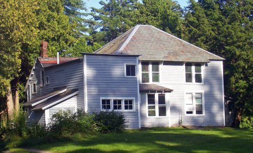 ★ Landmark



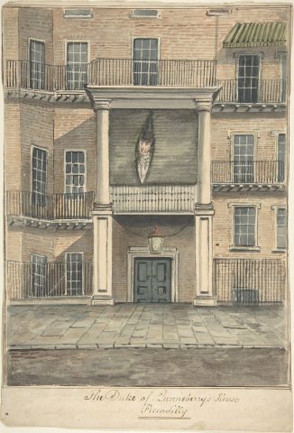 1850
 1858
 2008
 2008
 2008
 2008
 2008
 2005


