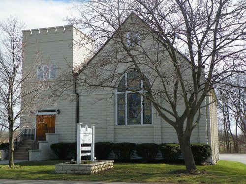
Ontario dates to 1806, and 18% of its homes were built before 1940
More historic than 78% of U.S. towns · #444 of 758 in New York. What drives it
2 places in town are on the National Register, among them a historic district with 8 buildings. Below: 10 old photos and papers, maps from 1900 on, and the census since 1820.
Founding year: Wikidata. First post office: 1823.The full story ↓
History grade
What drives Ontario’s History grade
On its age, its old homes and the National Register, Ontario is more historic than 78% of U.S. towns, #444 of 758 in New York. All 3 inputs are above most U.S. towns; its age ranks highest and its National Register listings lowest.
A−
HistoryA character grade: shown, never part of Ontario’s overall grade.
New York towns list more on the Register than most of the country (a typical New York town has 12.3 per 10,000 residents, the U.S. 2.4), so Ontario’s 8.6 sits near the middle of its state (44% of New York towns have fewer) while its 9 historic buildings outnumber those of 75% of U.S. towns.
How sure. Graded on any two of the three inputs instead, the letter would range from B+ to A−. The pre-1940 share is a Census survey estimate (±4.5 points). Two sources give 1806.
Founding year: Wikidata (other dates in Quick answers). Homes: Census ACS 2020–24. National Register: National Park Service, May 2026 list; each listing counted once (boundary changes and added documentation belong to their listing), and a historic district counts its contributing buildings. How TownRatings grades history →
What stands out about Ontario’s past
Read from the archive, the National Register and the record. The page puts what stands out first.
Lost post offices, old corners, places now gone and burying grounds
Ontario’s post office has been open since 1823. Three other post offices opened and closed inside today’s town.
Ontario
1823–today
Ontario Centre
1865–today
Lake Side
1866–1917
Furnaceville
1873–1900
Fruitland
1884–1934
18201920today
Hamlets and corners on the map
Bear CreekFruitlandFurnacevilleLakesideOntario CenterOntario on the LakeOrchard Grove Village ParkUnion Hill
Gone or out of use
School Number 1schoolSchool Number 10schoolSchool Number 11schoolSchool Number 12schoolSchool Number 13schoolSchool Number 13schoolSchool Number 7schoolSchool Number 8schoolSchool Number 9school
6cemeteries and burying grounds inside Ontario
CalvaryDickinsonFurnacevilleLakesideOntario CenterOntario Town
US Post Offices dataset (Blevins & Helbock, CC0). Places and cemeteries from the USGS Geographic Names Information System (2021).
On the map
Ontario on the map, 1900 to 1978
Every edition of the U.S. Geological Survey’s map of Ontario. Tap a year, or press play to watch the town change.
1900Macedon sheet · 1:62,500
U.S. Geological Survey historical topographic maps (public domain), via Esri’s collection of the scans. The red ring marks the center of Ontario.
Timeline
Ontario, 1800 to 1956
Woven from the archive, old maps, post office records, the National Register and the people born here.
The first settler was Freeman Hopkins, who arrived in 1806 from Rhode Island. He built a small log cabin that had to hold his nine children, wife and himself. Heavy timber and swamps made life difficult for the first settlers.
The town of Ontario was created in 1807 as the "Town of Freetown" from a part of the town of Williamson. Soon after, the name was changed to "Ontario". Part of Ontario was used to form the town of Walworth in 1829.
In 1811, iron ore was discovered and a thriving smelting operation arose that lasted until past the end of the century.
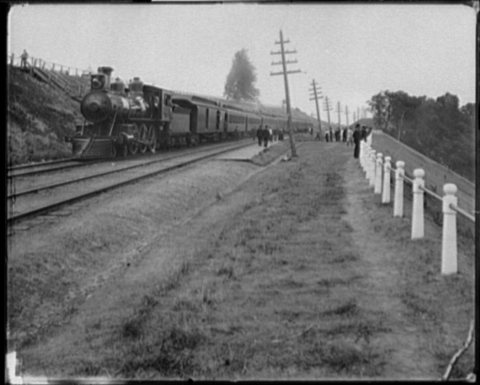
In 1874, the Lake Ontario Shore Railroad (now the Rome, Watertown and Ogdensburg Railroad) was opened.
Passages that mention Ontario, cut from the printed page as they were published.
History of Ontario county, New York1893 · page 113Read the page →
Read the text
As has been stated, Livingston and Monroe counties were created February 23, 1821, each taking lands from Ontario and Genesee counties. The next formation which took further from the territory of Ontario was Yates county created February 5, 1823, followed on the nth of April of the same year by the erection of Wayne county, the latter taking lands from Ontario and Seneca counties.
Text read by machine from the scan; it may contain errors.
History of Ontario county, New York1893 · page 414Read the page →
Read the text
that part of the old town which was in the gore, and also the eastern tier of lots in townships 9 and 10. Therefore, the subject of Ihis chapter must be the town of Seneca as constituted after the separate organization of Geneva as an independent civil division of Ontario county ; and as all that remains to be told in this connection relates to its early settlement and organization, we may properly begin with the advent of the pioneers into the region, referring only incidentally to the settlements at Kanadesaga and Geneva As the places last mentioned were
Text read by machine from the scan; it may contain errors.
History of the pioneer settlement of Phelps and Gorham's purchase, and Morris' reserve1851 · page 415Read the page →
Read the text
As early as April, 1797, all the region between the Genesee river and Lake Erie, was made a separate town of Ontario county, called Northampton. The first town meeting was held at the house of Peter Shaeffer. " The vote was taken by Gad Wadsworth, Esq., of the town of Hartford." Josiah Fish was chosen supervisor, Eli Granger, town clerk. Other town officers : — Joseph Morgan, Josiah Fish, Peter Shaeffer, Elijah Kent, Jeremiah Olmsted, Gideon King, Christopher Dugan, Isaac Scott, Hinds Chamberlin, Simon
Text read by machine from the scan; it may contain errors.
History of the pioneer settlement of Phelps and Gorham's purchase, and Morris' reserve1851 · page 450Read the page →
Read the text
From the coinmencoment of settlement, until 1805, Allegany was a part of the town of Leicester, Ontario county, and the new settlers had to go to the old village of Leicester on the Genesee river, via Hornersville, to town meeting. In "805 what is now Allegany county, was erected into a new town, and called Angelica. In April of that year the first town meeting was held at the house of Joseph Taylor. Benjamin Briggs was elected supervisor, Jacob S.
Text read by machine from the scan; it may contain errors.
Scans and text from the Internet Archive. Books published in 1930 or earlier, which are in the public domain.
By decade
Ontario, decade by decade
7 decades in the archive, from the 1800s to the 1890s. Scroll each row; tap a photo for its story.
Nothing in the archives for these yearsWeddings on Main Street, storms, parades, school pictures, the old store. If it’s in your family album, it belongs here.
Fire insurance maps drew every building, what it was made of and what it was used for, so insurers could price the risk of fire. Pick a year, then a sheet.
1906Sheet 1 of 1
Edition
Sheets
BrickWoodStone
Sanborn Map Company, via the Library of Congress. Editions published in 1930 or earlier, which are in the public domain.
Then & now
Stand where they stood
No then-and-now pairs yet. Take a photo from the same spot as an old one and they appear here side by side.
Retake this viewYork, on Lake Ontario, 1800
Find the spot, match the angle, and add your photo. It becomes the first then-and-now pair on Ontario’s page.
In 1806, according to Wikidata. Ontario’s post office opened in 1823, and the census of 1820 counted 2,233 people here.
How does Ontario rank for history?
Ontario is more historic than 78% of U.S. towns, #444 of 758 in New York. The History grade combines the town’s founding era, the share of homes built before 1940 and its National Register listings. It’s a character grade, so it isn’t part of the overall grade. How it works.
What is on the National Register in Ontario?
Two places: the Brick Church Corners (listed 1974) and the First Presbyterian Church of Ontario Center (1998).
How old are the homes in Ontario?
18% of Ontario’s homes were built before 1940 (Census estimate, ±4.5 points), against a typical 27% for a New York town; the median home was built in 1978.
Founding dates: Wikidata, Wikipedia, the U.S. post office records of Blevins & Helbock (CC0) and the Census. Homes by year built: Census ACS 2020–24. National Register of Historic Places: National Park Service (list of May 22, 2026). Old photos, postcards and papers: Wikimedia Commons, the Library of Congress and other public archives, credited on each item’s page. Maps: U.S. Geological Survey historical topographic maps (via Esri) and Sanborn fire-insurance maps (Library of Congress). History text and census tables: Wikipedia (CC BY-SA 4.0). Places that used to be: USGS Geographic Names Information System (2021).
From Wikimedia Commons (2), the Library of Congress (8), the National Register of Historic Places (2), Wikipedia, Wikidata and Wikipedia for famous people, U.S. Geological Survey historical maps, U.S. Census counts (via Wikipedia), the US Post Offices dataset (Blevins & Helbock), the USGS Geographic Names Information System, Sanborn fire insurance maps (Library of Congress) and old county and town histories (Internet Archive). Archive images are copied here with their credits and licenses, shown on each photo’s page. Refreshed monthly.


 1860
 1866
 1874
 1890