Founding year: Wikipedia. First post office: 1828.The full story ↓
History grade
What drives Montgomery’s History grade
On its age, its old homes and the National Register, Montgomery is more historic than 94% of U.S. towns, #162 of 758 in New York. All 3 inputs are above most U.S. towns; its age ranks highest and its share of homes from before 1940 lowest.
A
HistoryA character grade: shown, never part of Montgomery’s overall grade.
New York towns list more on the Register than most of the country (a typical New York town has 12.3 per 10,000 residents, the U.S. 2.4), so Montgomery’s 316 sits above most of its state (87% of New York towns have fewer) while its 120 historic buildings outnumber those of 90% of U.S. towns.
NoteThe founding year comes from Wikipedia alone; no second source gives 1772.
How sure. Graded on any two of the three inputs instead, the letter would range from A to A+. The pre-1940 share is a Census survey estimate (±6.5 points).
Founding year: Wikipedia (other dates in Quick answers). Homes: Census ACS 2020–24. National Register: National Park Service, May 2026 list; each listing counted once (boundary changes and added documentation belong to their listing), and a historic district counts its contributing buildings. How TownRatings grades history →
What stands out about Montgomery’s past
Read from the archive, the National Register and the record. The page puts what stands out first.
Fire insurance maps drew every building, what it was made of and what it was used for, so insurers could price the risk of fire. Pick a year, then a sheet.
1885Sheet 1 of 1
Edition
Sheets
BrickWoodStone
Sanborn Map Company, via the Library of Congress. Editions published in 1930 or earlier, which are in the public domain.
On the map
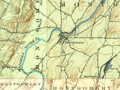
Montgomery on the map, 1903 to 1957
Every edition of the U.S. Geological Survey’s map of Montgomery. Tap a year, or press play to watch the town change.
1903Newburgh sheet · 1:62,500
U.S. Geological Survey historical topographic maps (public domain), via Esri’s collection of the scans. The red ring marks the center of Montgomery.
The early town began as a patent to Henry Wileman in 1710, who was the first settler. He was the first of a group of Palatine Germans to emigrate and settle land around what is now the village of Montgomery.
The town was originally established as Hanover in 1772, but became the town of Montgomery in 1782.
The community of Montgomery was set off by incorporation as a village in 1810, and in 1855, the community of Walden was incorporated as well. Maybrook was the last village to be incorporated, in 1926.
Passages that mention Montgomery, cut from the printed page as they were published.
Biographical annals of Montgomery County, Pennsylvania, containing genealogical records of representative families, including many of the early settlers and biographical sketches of prominent citizens1904Read the page →
Read the text
Mrs. Berkhimer's family are old residents of Pennsylvania, but they have been domiciled in Montgomery county only for two generations. Her father, Levi Shepherd, was a miller, and resided at Tacony, in Philadelphia county, whence he removed about 1834 to Moreland, in Montgomery county, and in 1843 to Montgomery township. Mrs. Berkhimer was born at Tacony, but
Text read by machine from the scan; it may contain errors.
Montgomery County, Pennsylvania1923 · page 123Read the page →
Read the text
founded in this county in Whitemarsh township in 1710, and ten years later St. James Church was founded in Providence (now Lower), and by 1832 these churches had increased to four and in 1870 to ten. There are now about a dozen Episcopal churches in Montgomery county. The list of parishes given in 1890 for this county is thus: St. Thomas' congregation of Whitemarsh, founded in 1710; St. James' Church of Lower Providence, organized 1730; St. John's of Norristown, 1812; Christ's of Pottstown, 1828; Church of the Redeemer, Lower Merion, 1848; St.
Text read by machine from the scan; it may contain errors.
Montgomery County, Pennsylvania1923 · page 151Read the page →
Read the text
The Philadelphia Theological Seminary of St. Charles Borromeo is a Roman Catholic educational institution, where students are fitted for the priesthood. It is situated in Montgomery county, at Overbrook, a station on the main line of the Pennsylvania railway, about five miles out of the city of Philadelphia, but over the line in Montgomery county.
Text read by machine from the scan; it may contain errors.
(Contributed) Will someone please give me the descendants of Hugh Montgomery of the family of John and Mary Strobridge Montgomery? Can someone give the names of the first Montgomerys coming to this country? My ancestor, William, was son of William Montgomery and Susan Halliday and his father was Samuel Montgomery, and the Montgomery Sears of Boston were
Text read by machine from the scan; it may contain errors.
Scans and text from the Internet Archive. Books published in 1930 or earlier, which are in the public domain.
Timeline
Montgomery, 1772 to 1993
Woven from the archive, old maps, post office records, the National Register and the people born here.
In 1772, according to Wikipedia’s history of the town. Montgomery’s post office opened in 1828, and the first U.S. census counted 3,563 people here in 1790.
How does Montgomery rank for history?
Montgomery is more historic than 94% of U.S. towns, #162 of 758 in New York. The History grade combines the town’s founding era, the share of homes built before 1940 and its National Register listings. It’s a character grade, so it isn’t part of the overall grade. How it works.
How old are the homes in Montgomery?
17% of Montgomery’s homes were built before 1940 (Census estimate, ±6.5 points), against a typical 27% for a New York town; the median home was built in 1976.
Founding dates: Wikidata, Wikipedia, the U.S. post office records of Blevins & Helbock (CC0) and the Census. Homes by year built: Census ACS 2020–24. National Register of Historic Places: National Park Service (list of May 22, 2026). Old photos, postcards and papers: Wikimedia Commons, the Library of Congress and other public archives, credited on each item’s page. Maps: U.S. Geological Survey historical topographic maps (via Esri) and Sanborn fire-insurance maps (Library of Congress). History text and census tables: Wikipedia (CC BY-SA 4.0). Places that used to be: USGS Geographic Names Information System (2021).
From Wikidata (5), Wikipedia, Wikidata and Wikipedia for famous people, U.S. Geological Survey historical maps, U.S. Census counts (via Wikipedia), Sanborn fire insurance maps (Library of Congress) and old county and town histories (Internet Archive). Archive images are copied here with their credits and licenses, shown on each photo’s page. Refreshed monthly.