Most of Medford was built recently: 5% of its homes predate 1940 and the median home dates from 1975. Below: 4 old photos and papers and maps from 1904 on.
The Long Island Rail Road established the Medford station in 1843 in a flat wilderness in the Long Island Central Pine Barrens. The station connected to the Patchogue Stage Road between Patchogue and Port Jefferson, and a post office was established.
In 1907 the LIRR established the Medford Prosperity Farm (officially called Experimental Station #2) on 80 acres (320,000 m2) to show that crops could be raised in the Pine Barrens. Theodore Roosevelt visited the station in August 1910. As the car drove across a trail between Medford and Wading River, it got stuck in the mud and Roosevelt was said to take a "flying leap" to get out.
Nothing in the archives for these yearsWeddings on Main Street, storms, parades, school pictures, the old store. If it’s in your family album, it belongs here.
Nothing in the archives for these yearsWeddings on Main Street, storms, parades, school pictures, the old store. If it’s in your family album, it belongs here.
Founding dates: Wikidata, Wikipedia, the U.S. post office records of Blevins & Helbock (CC0) and the Census. Homes by year built: Census ACS 2020–24. National Register of Historic Places: National Park Service (list of May 22, 2026). Old photos, postcards and papers: Wikimedia Commons, the Library of Congress and other public archives, credited on each item’s page. Maps: U.S. Geological Survey historical topographic maps (via Esri) and Sanborn fire-insurance maps (Library of Congress). History text and census tables: Wikipedia (CC BY-SA 4.0). Places that used to be: USGS Geographic Names Information System (2021). How TownRatings grades history →
From Wikimedia Commons (6), Wikipedia, Wikidata and Wikipedia for famous people and U.S. Geological Survey historical maps. Archive images are copied here with their credits and licenses, shown on each photo’s page. Refreshed monthly.


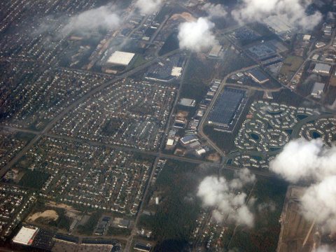 2007
 2000