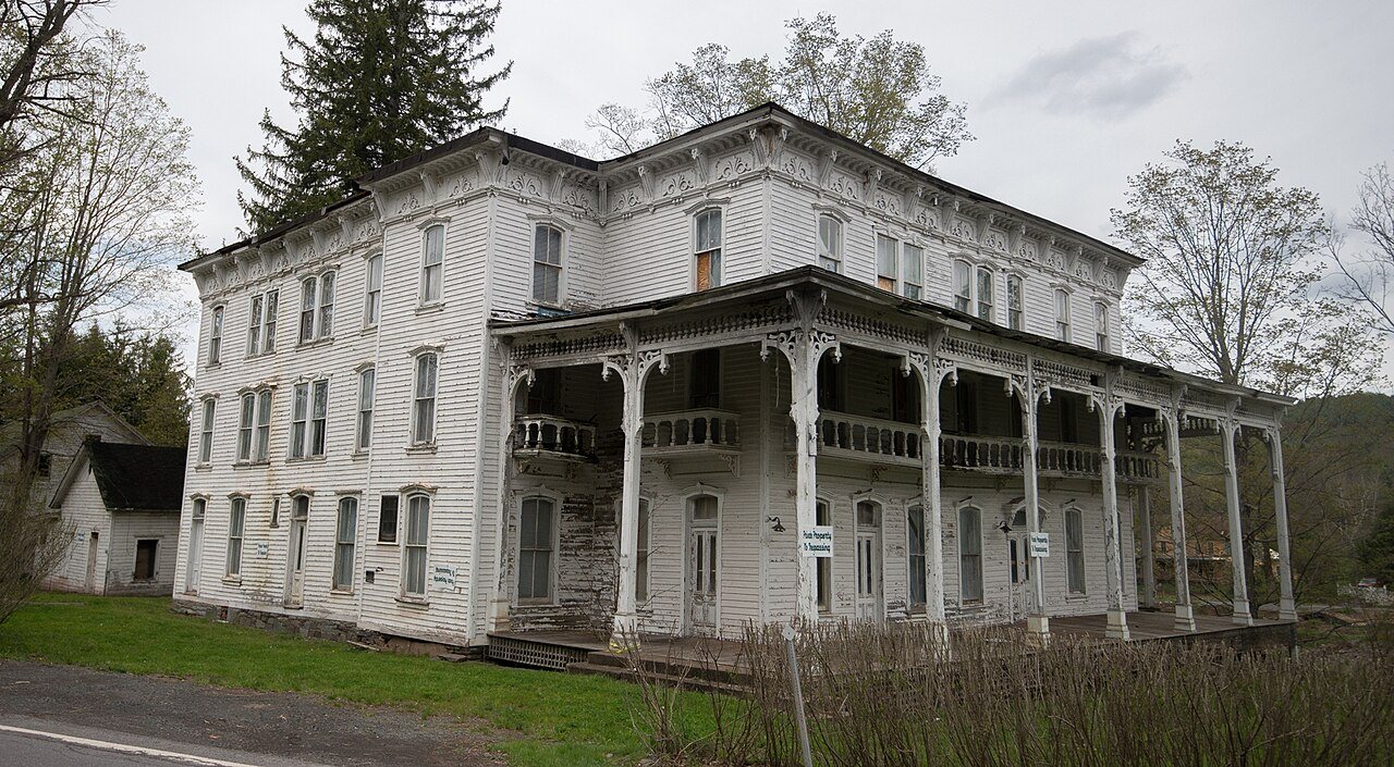
Share Lexington House · Photo: RobertDrake2015 · CC BY-SA 3.0 – Not graded Outdoors in Lexington
More than half of Lexington’s land is conserved: 56% 56% of Lexington’s land is conserved, about 28,617 acres. The biggest trail networks: Hunter-West Kill Wilderness (16.2 mi), Halcott Mountain Wild Forest (3.4 mi), Rusk Mountain Wild Forest (2.4 mi). 8,789 acres are parks and preserves, 11,518 per 1,000 residents.
Conserved land
56%
28,617 acres · of 80.2 sq mi of land
Trails
44 mi
0.5 per sq mi of land
Park land
8,789 ac
11,518 acres per 1,000 residents
Near a park
42%
of residents within ½ mile
Highest peak
3,898 ft
West Kill Mountain
The map Conserved land, trails & bike routes Tap a number to zoom to a park. Tap a layer to hide it.
Diamond Notch Falls Buck Ridge Lookout view east view south Unnamed scenic view in Halcott Mountain Wild Forest Unnamed scenic view in Hunter-West Kill Wilderness Unnamed scenic view in Hunter-West Kill Wilderness Unnamed scenic view in Hunter-West Kill Wilderness Unnamed scenic view in Hunter-West Kill Wilderness Unnamed scenic view in Rusk Mountain Wild Forest Unnamed scenic view in Rusk Mountain Wild Forest West Kill Mountain North Dome Mount Sherrill North Bearpen Mountain Halcott Mountain Saint Anne's Peak Sleeping Lion South Vly Balsam Mountain Pine Island Mountain Packsaddle South Sherrill South Broadstreet Hollow Vinegar Hill Kipp Hill Maben Hill 1 2 3 4 5 6 7 8 Show all of Lexington Places to walk Pick a walk The longest trail network is Hunter-West Kill Wilderness, with 16.2 miles. Directions go to the nearest trailhead or public parking.
All 8 1–3 mi 6 3+ mi 2 100+ acres 7
1 Hunter-West Kill Wilderness Nature preserve
17,368 acres16.2 mi of trail
Devil's Path Sherrill and North Dome Herd Path Diamond Notch Trail Herd Path +1
2 Halcott Mountain Wild Forest Nature preserve
4,225 acres3.4 mi of trail
Halcott Mountain Herd Path
3 Rusk Mountain Wild Forest Managed by New York State Department of Environmental Conservation
2,730 acres2.4 mi of trail
Rusk Herd Path Spruceton Trail
4 Bearpen Mountain State Forest Nature preserve
400 acres2.3 mi of trail
Snowmobile Trail
5 Beech Ridge Unit Managed by New York City Department of Environmental Protection, Bureau of Water Supply
721 acres1.7 mi of trail
Bonnie's Trails
6 Vinegar Hill Wildlife Management Area Nature preserve
401 acres1.7 mi of trail
Vinegar Hill Trail
7 Little Westkill Unit Managed by New York City Department of Environmental Protection, Bureau of Water Supply
312 acres1.4 mi of trail
8 Diamond Notch Primitive Bicycle Corridor Nature preserve
27 acres1.1 mi of trail
Diamond Notch Trail
All 22 parks & preserves Hunter-West Kill Wilderness 17,368 acres · 16.2 mi of trail
Directions Halcott Mountain Wild Forest 4,225 acres · 3.4 mi of trail
Directions Rusk Mountain Wild Forest 2,730 acres · 2.4 mi of trail · New York State Department of Environmental Conservation
Directions Bearpen Mountain State Forest 400 acres · 2.3 mi of trail
Beech Ridge Unit 721 acres · 1.7 mi of trail · New York City Department of Environmental Protection, Bureau of Water Supply
Directions Vinegar Hill Wildlife Management Area 401 acres · 1.7 mi of trail
Directions Little Westkill Unit 312 acres · 1.4 mi of trail · New York City Department of Environmental Protection, Bureau of Water Supply
Directions Diamond Notch Primitive Bicycle Corridor 27 acres · 1.1 mi of trail
Directions North Lexington Unit 197 acres · 0.8 mi of trail · New York City Department of Environmental Protection, Bureau of Water Supply
Balsam Mountain Unit 844 acres · 0.6 mi of trail · New York City Department of Environmental Protection, Bureau of Water Supply
Maben Hill Unit 328 acres · 0.2 mi of trail · New York City Department of Environmental Protection, Bureau of Water Supply
Directions Shandaken Wild Forest 1,301 acres
Pine Island Mountain Unit 585 acres · New York City Department of Environmental Protection, Bureau of Water Supply
Westkill Unit 344 acres · New York City Department of Environmental Protection, Bureau of Water Supply
Directions John Chase Brook Unit 61 acres · New York City Department of Environmental Protection, Bureau of Water Supply
Roarback Brook Unit 47 acres · New York City Department of Environmental Protection, Bureau of Water Supply
Tumbleweed Unit 28 acres · New York City Department of Environmental Protection, Bureau of Water Supply
Directions Airport Road Unit 22 acres · New York City Department of Environmental Protection, Bureau of Water Supply
Lanes Brook Unit 17 acres · New York City Department of Environmental Protection, Bureau of Water Supply
Park Road Unit 10 acres · New York City Department of Environmental Protection, Bureau of Water Supply
Mosquito Point Unit 8 acres · New York City Department of Environmental Protection, Bureau of Water Supply
Directions Spruceton Unit 8 acres · New York City Department of Environmental Protection, Bureau of Water Supply
Who protects it 28,617 conserved acres 56% of Lexington’s land. Who manages Lexington’s conserved land, from the USGS Protected Areas Database. Approximate, because parcels can overlap.
State conservation 29,351 ac
Town or city 181 ac
Land trusts & nonprofits 79 ac
County 8 ac
Other state land 5 ac
State Wilderness · 17,373 ac State Conservation Area · 8,669 ac Recreation or Education Easement · 1,386 ac State Resource Management Area · 858 ac Other Easement · 711 ac
Good to know Conserved doesn’t always mean open to visitors. 1,947 acres are conservation easements, usually private land. The walks above are places people visit.
The biggest protected parcels
Parcel (PAD-US) Managed by Acres Public access Hunter-West Kill WildernessState Wilderness
State conservation 17,373 Open Halcott Mountain Wild ForestState Conservation Area
State conservation 4,232 Open Rusk Mountain Wild ForestState Conservation Area
State conservation 2,728 Open Shandaken Wild ForestState Conservation Area
State conservation 1,308 Open Border Hunter / West KillState Resource Management Area
State conservation 446 Open Bearpen Mountain State ForestState Conservation Area
State conservation 406 Open Vinegar Hill WmaState Resource Management Area
State conservation 404 Open New York City WatershedWatershed Protection Area
Town or city 116 Closed Catskill MountainsPrivate Conservation
Land trusts & nonprofits 79 Closed New York City Dept. of Environmental Protection 1Watershed Protection Area
Town or city 36 Closed
4 smaller protected places aren’t shown.
Things to do 27 places to go in Lexington Beaches, playgrounds, peaks, falls and more. Pick a kind.
1 Waterfall 10 Scenic views 16 Peaks
Waterfalls in Lexington Show all on map
Diamond Notch Falls In Diamond Notch Primitive Bicycle Corridor
Map Directions Scenic views in Lexington Show all on map
Buck Ridge Lookout In Hunter-West Kill Wilderness
Map Directions view east In Hunter-West Kill Wilderness
Map Directions view south In Hunter-West Kill Wilderness
Map Directions Plus 7 scenic views without a name on the map. Tap “Show all on map” to see them.
Peaks in Lexington Show all on map
West Kill Mountain 3,898 ft elevation · In Hunter-West Kill Wilderness
Map Directions North Dome 3,605 ft elevation · In Hunter-West Kill Wilderness
Map Directions Mount Sherrill 3,558 ft elevation · In Hunter-West Kill Wilderness
Map Directions North Bearpen Mountain 3,530 ft elevation
Map Directions Halcott Mountain 3,509 ft elevation · In Halcott Mountain Wild Forest
Map Directions Saint Anne's Peak 3,422 ft elevation · In Hunter-West Kill Wilderness
Map Directions Sleeping Lion 3,409 ft elevation · In Halcott Mountain Wild Forest
Map Directions South Vly 3,360 ft elevation · In Beech Ridge Unit
Map Directions 8 more peaks Balsam Mountain 3,353 ft elevation · In Hunter-West Kill Wilderness
Map Directions Pine Island Mountain 3,140 ft elevation · In Pine Island Mountain Unit
Map Directions Packsaddle 3,100 ft elevation · In Rusk Mountain Wild Forest
Map Directions South Sherrill 2,884 ft elevation · In Hunter-West Kill Wilderness
Map Directions South Broadstreet Hollow 2,802 ft elevation · In Hunter-West Kill Wilderness
Map Directions Trails & water
10 named trails and 2 lakes & rivers Named trails
Open to bikes · 2.6 mi Horses · 2.1 mi Unpaved · 31.3 mi
Devil's Path 7.3 mi
Sherrill and North Dome Herd Path 3.9 mi
Diamond Notch Trail 2.6 mi
Spruceton Trail 2.0 mi
Snowmobile Trail 2.0 mi
Bonnie's Trails 1.6 mi
Halcott Mountain Herd Path 1.6 mi
Rusk Herd Path 1.4 mi
Vinegar Hill Trail 1.2 mi
Herd Path 1.1 mi
Lakes & rivers tap for directions
Biking & sports 0.0 miles of bike routes Bike lanes are often missing from the map in smaller towns, so that number is likely low.
Courts & fields
15 Tennis
6 Basketball
4 Baseball
Includes school and college facilities, which aren’t always open to the public.
History along the way 3 places on the National Register The country’s official list of places worth saving (National Park Service). The map also marks 1 historic points from OpenStreetMap: plaques, memorials and old buildings.
History → Lexington House Building · listed 1986
About it Hunter Mountain Fire Tower Structure · listed 1997
About it St. Francis DeSales Church Building · listed 1999
About it When to get out The best walking months in Lexington: May and July NOAA’s 1991–2020 normals for the town and the daylight at its latitude. Outlined months have long days, highs of 59 to 86 °F and little rain for the place.
Jan Feb Mar Apr May Jun Jul Aug Sep Oct Nov Dec Daylight (h) 9.4 10.5 11.8 13.3 14.6 15.2 15.0 13.9 12.4 11.0 9.7 9.1 High (°F) 31 34 42 55 67 75 79 78 71 58 46 36 Rain (in) 2.7 2.3 3.3 3.4 3.7 4.4 4.0 4.3 4.2 4.3 3.1 3.2
February is the driest month (2.3 in) and July the warmest (highs of 79 °F). 4.4 inches fall in June, the wettest month. The climate in Lexington →
Next door Lexington and its neighbors Tap a town to see its outdoors.
Town Conservedof land Trail miper sq mi Park acresper 1,000 Near a park½ mile Outdoors Lexington — not graded: under 1,000 residents or part of its town Jewett — not graded: under 1,000 residents or part of its town Ashland — not graded: under 1,000 residents or part of its town Hunter 56% 1.7 3,121 78% A+ Halcott — not graded: under 1,000 residents or part of its town Shandaken 70% 1.0 3,550 78% A+ Prattsville — not graded: under 1,000 residents or part of its town
The four inputs of the Outdoors grade, from the engine; shares are of land, not water.
Questions about parks and trails in Lexington Where can I hike in Lexington? The longest trail networks: Hunter-West Kill Wilderness, 16.2 miles; Halcott Mountain Wild Forest, 3.4 miles; Rusk Mountain Wild Forest, 2.4 miles; Bearpen Mountain State Forest, 2.3 miles. Each one is on the map above, with directions to the nearest trailhead or parking.
Are dogs allowed on Lexington’s trails? Hunter-West Kill Wilderness and Halcott Mountain Wild Forest don’t have dog rules recorded on the map; check the signs at the trailhead.
Is there public land near Lexington? 160,347 acres of parks and open public land lie inside Lexington or within 10 miles of it (PAD-US), 26,758 of them inside the town line.
Trail talk Conditions, parking and favorite walks from Lexington neighbors.
Town Square → Share a tip
Trail muddy, icy or closed? Give neighbors a heads-up → Where do you park for Hunter-West Kill Wilderness? → Are dogs allowed at Hunter-West Kill Wilderness? → What’s your favorite walk in Lexington? → Sources
Where this page comes from Conserved and public land: USGS Protected Areas Database of the United States (PAD-US), service updated July 2026. Parks, trails, playgrounds, beaches and other places: OpenStreetMap (© OpenStreetMap contributors , ODbL), map data as of 2026-10-28. Land and water area: Census 2025 Gazetteer. Residents near a park: 2020 Census blocks. National Register: National Park Service. How TownRatings grades the outdoors →
 Lexington House · Photo: RobertDrake2015 · CC BY-SA 3.0