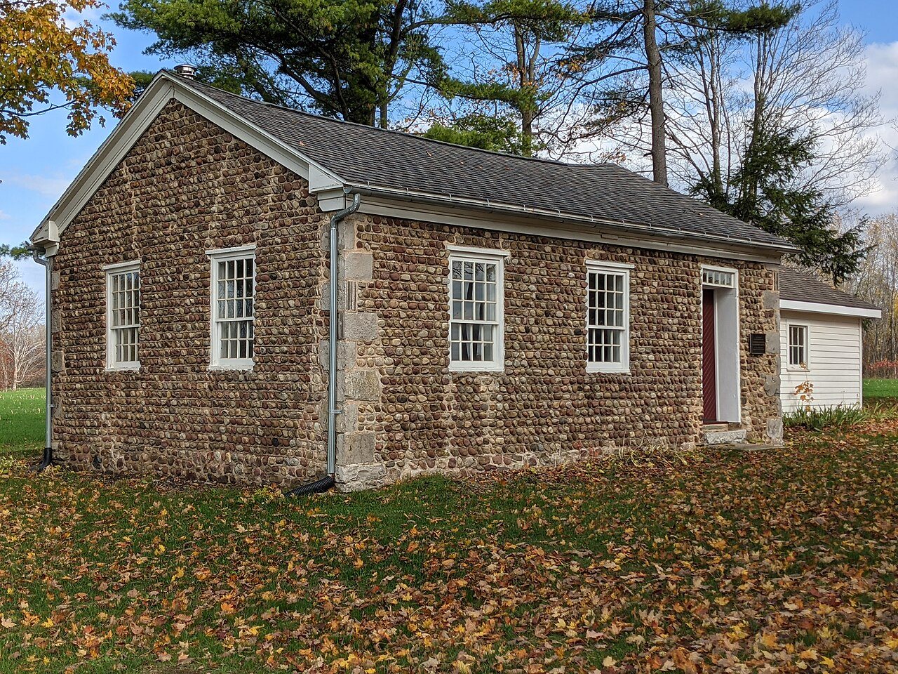
Its Register listings are the Methodist Episcopal Church of Butler and the Roe Cobblestone Schoolhouse. Below: 1 old photo or paper, maps from 1902 on, and the census since 1830.
Founding year: Wikidata. First post office: 1828.The full story ↓
History grade
What drives Butler’s History grade
On its age, its old homes and the National Register, Butler is more historic than 89% of U.S. towns. All 3 inputs are above most U.S. towns; its share of homes from before 1940 ranks highest and its National Register listings lowest.
A
HistoryA character grade: shown, never part of Butler’s overall grade.
New York towns list more on the Register than most of the country (a typical New York town has 12.3 per 10,000 residents, the U.S. 2.4), so Butler’s 11.4 sits near the middle of its state (48% of New York towns have fewer) while its 2 listings outnumber those of 60% of U.S. towns.
How sure. Graded on any two of the three inputs instead, the letter would range from B+ to A+. The pre-1940 share is a Census survey estimate (±17.8 points). Two sources give 1803.
Founding year: Wikidata (other dates in Quick answers). Homes: Census ACS 2020–24. National Register: National Park Service, May 2026 list; each listing counted once (boundary changes and added documentation belong to their listing), and a historic district counts its contributing buildings. How TownRatings grades history →
What stands out about Butler’s past
Read from the archive, the National Register and the record. The page puts what stands out first.
The Town of Butler was formed from the Town of Wolcott in 1826.
Butler Correctional Facility was a New York State medium security prison. Butler Correctional Facility was located in the northeastern part of town near the hamlet of Westbury. It closed on July 26, 2014, under the Governor Andrew Cuomo's Administration.
The Roe Cobblestone Schoolhouse was listed on the National Register of Historic Places in 2008.
Passages that mention Butler, cut from the printed page as they were published.
History of Butler County, Iowa, a record of settlement, organization, progress and achievement1914 · page 313Read the page →
Read the text
EARLY SETTLEMENT As has been indicated in connection with the history of Butler township, the first permanent settlements within the limits of Butler county were made near the east bank of the Shell Rock river, within the borders of what was later set off as Jackson township. These settlements and the early settlers were so cl()sely identified with the early history of Biitler township as to have been named in the se])arate history of that township, many
Text read by machine from the scan; it may contain errors.
History of Butler County, Iowa, a record of settlement, organization, progress and achievement1914 · page 205Read the page →
Read the text
division of government. Accordingly, on Feb. 6, 1855, County Judge John Palmer made the following division of the county into four townships: ''The township of Butler, to consist of congressional townships 92 and 93, range 15, and township 92 and the east half of 93, range 16; the township of Coldwater, of congressional township 93, range 17, and the east half of township 93, range 16 ; the township of Ripley, to consist of congressional townships 90, 91 and
Text read by machine from the scan; it may contain errors.
History of Butler County Kansas1916 · page 72Read the page →
Read the text
Postoffice — The nearest established postoffice when the first settlement was made in Butler county was at Lawrence. Box 400 was rented by the settlers of the county, and mail so addressed was brought down to Emporia by means of a tri-weekly hack between that place and Lawrence. From Emporia mail was sent down to Butler by anybody who happened to be passing that way. The first distributing station in the county was established at Chelsea in 1858, with C. S. Lambdin as postmaster. The second postoffice in the county was established at El
Text read by machine from the scan; it may contain errors.
History of Butler County Kansas1916 · page 709Read the page →
Read the text
J. L. Hunt was about fifteen years of. age when he came to Butler county with his father, and he has a distinct recollection of the conditions that existed in Butler county in the early days and can relate many interesting incidents of pioneer life. He came here at a time when Butler county was in its early formative period and saw much of Butler county's history in the making, as it were. When he was a boy he worked for fifty cents a day, hauling rock. He had his experiences with the early day prairie fires and other elements of destruction
Text read by machine from the scan; it may contain errors.
Scans and text from the Internet Archive. Books published in 1930 or earlier, which are in the public domain.
Timeline
Butler, 1803 to 1902
Woven from the archive, old maps, post office records, the National Register and the people born here.
In 1803, according to Wikidata. Butler’s post office opened in 1828, and the census of 1830 counted 1,764 people here.
How does Butler rank for history?
Butler is more historic than 89% of U.S. towns. The History grade combines the town’s founding era, the share of homes built before 1940 and its National Register listings. It’s a character grade, so it isn’t part of the overall grade. How it works.
What is on the National Register in Butler?
Two places: the Methodist Episcopal Church of Butler (listed 1997) and the Roe Cobblestone Schoolhouse (2008).
How old are the homes in Butler?
52% of Butler’s homes were built before 1940 (Census estimate, ±17.8 points), against a typical 27% for a New York town; the median home was built in 1938.
Founding dates: Wikidata, Wikipedia, the U.S. post office records of Blevins & Helbock (CC0) and the Census. Homes by year built: Census ACS 2020–24. National Register of Historic Places: National Park Service (list of May 22, 2026). Old photos, postcards and papers: Wikimedia Commons, the Library of Congress and other public archives, credited on each item’s page. Maps: U.S. Geological Survey historical topographic maps (via Esri) and Sanborn fire-insurance maps (Library of Congress). History text and census tables: Wikipedia (CC BY-SA 4.0). Places that used to be: USGS Geographic Names Information System (2021).
From Wikimedia Commons (1), the National Register of Historic Places (2), Wikipedia, U.S. Geological Survey historical maps, U.S. Census counts (via Wikipedia), the US Post Offices dataset (Blevins & Helbock), the USGS Geographic Names Information System and old county and town histories (Internet Archive). Archive images are copied here with their credits and licenses, shown on each photo’s page. Refreshed monthly.