Paterson dates to 1792, and 33% of its homes were built before 1940
More historic than 96% of U.S. towns · #28 of 468 in New Jersey. What drives it
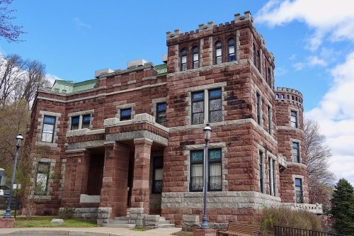
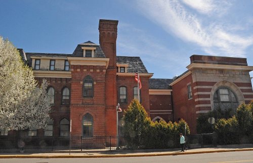
19 places in town are on the National Register, among them 2 National Historic Landmarks and five historic districts with 1,043 buildings between them. Below: 12 old photos and papers, maps from 1887 on, and the census since 1840.
Founding year: Wikidata. First post office: 1812.The full story ↓
History grade
What drives Paterson’s History grade
On its age, its old homes and the National Register, Paterson is more historic than 96% of U.S. towns, #28 of 468 in New Jersey. All 3 inputs are above most U.S. towns; its National Register listings ranks highest and its age lowest.
A+
HistoryA character grade: shown, never part of Paterson’s overall grade.
Among the 400 U.S. cities of 100,000 or more, Paterson ranks #39 on History.
New Jersey towns list more on the Register than most of the country (a typical New Jersey town has 3.7 per 10,000 residents, the U.S. 2.4), so Paterson’s 66.8 sits above most of its state (83% of New Jersey towns have fewer) while its 1,061 historic buildings outnumber those of 99% of U.S. towns.
How sure. Graded on any two of the three inputs instead, the letter would range from A to A+. The pre-1940 share (±1.9 points) is firm at this size. Two sources give 1792.
Founding year: Wikidata (other dates in Quick answers). Homes: Census ACS 2020–24. National Register: National Park Service, May 2026 list; each listing counted once (boundary changes and added documentation belong to their listing), and a historic district counts its contributing buildings. How TownRatings grades history →
What stands out about Paterson’s past
Read from the archive, the National Register and the record. The page puts what stands out first.
The country’s official list of buildings and places worth saving. 2 are National Historic Landmarks, the highest tier. Boundary changes and added documentation are counted with their listing.
The area of Paterson was inhabited by the Algonquian-speaking Native American Acquackanonk tribe of the Lenape, also known as the Delaware Indians. The land was known as the Lenapehoking. The Dutch claimed the land as New Netherlands, followed by the British as the Province of New Jersey.
Passages that mention Paterson, cut from the printed page as they were published.
A history of industrial Paterson1882 · page 32Read the page →
Read the text
meeting was also held at Little Falls, whence propositions were submitted for acceptance. Governor Duer appears to have favored the latter, but a committee to whom the subject had been referred thought differently and on May 17th, 1792, resolved that the town of Paterson (named after the Governor of the State) should be located at the Great Falls of the Passaic. A committee to lay out the town of Paterson, which some insisted should be named "Hamilton," after the indefatigable statesman and zealous projector, was appointed at a meeting held July 6th, in the same year, consisting of Directors Low, Bayard and Boudmot, and they were
Text read by machine from the scan; it may contain errors.
Art. 1st. The said John Wallis agrees to sell, convey and dispose of, to the said Hutcheson, all the wood and timber growing and being upon a certain piece of land owned by the said Wallis, situate lying and being in the Township of Saddle Biver County of Bergen and State of New Jersey, near Paterson Bridge, and which was formerly owned by George Adams, late ot the Town of Paterson, for the consideration of forty-five dollars, to be secured by an approved promissory Note, payable on the first day of November next, and for the further consideration of the said Hutcheson cutting and clearing from off the said land, or all
Text read by machine from the scan; it may contain errors.
History of the city of Paterson and the County of Passaic, New Jersey1901 · page 65Read the page →
Read the text
tract actually comprised about ten thousand acres, to wit : Acquackanonk township, as it remains at this day, 5,500 acres ; Passaic, Second and Third wards, 500 acres ; all of the Third, Fourth and Fifth wards of Paterson, nearly all of the Sixth and Eighth wards, and about half of the Seventh ward, or about 4,000 of the 5,357 acres in the city of Paterson, being included in this ancient conveyance. The westerly line in Paterson ran from the mouth of a brook near the
Text read by machine from the scan; it may contain errors.
History of the city of Paterson and the County of Passaic, New Jersey1901 · page 316Read the page →
Read the text
VII. Eliza, b. Aug. 23, 1793; m. James Bunn, of Woodbridge, Middlesex county, N. J.; d. Aug. 20, 1885, at East Rockaway, L. I. Issue: I. James, b. Aug. 19, 1814, in New York; he came to Paterson in 1826, to sell clams and oysters, and subsequently kept hotel in Paterson for many years. His reminiscences of men and events in Paterson in the olden times, told in his inimitable manner, have enlivened many a social gathering. After managing the United
Text read by machine from the scan; it may contain errors.
Scans and text from the Internet Archive. Books published in 1930 or earlier, which are in the public domain.
Timeline
Paterson, 1792 to 2013
Woven from the archive, old maps, post office records, the National Register and the people born here.
Nothing in the archives for these yearsWeddings on Main Street, storms, parades, school pictures, the old store. If it’s in your family album, it belongs here.
Fire insurance maps drew every building, what it was made of and what it was used for, so insurers could price the risk of fire. Pick a year, then a sheet.
Lost post offices, old corners, places now gone and burying grounds
Paterson’s post office has been open since 1812. Another post office, Lake View, opened and closed inside today’s town.
Paterson
1812–today
Lake View
1871–1901
18101920today
Hamlets and corners on the map
Lake ViewRiversideRiverside Terrace
Gone or out of use
Broadway TabernaclechurchCongregation B'nai IsraelchurchEastside Branch Paterson Free Public LibrarybuildingEastside High School AnnexschoolPaterson Catholic Regional High SchoolschoolPaterson City Normal SchoolschoolPublic School 23schoolSaint Agnes SchoolschoolSaint Bonaventures SchoolschoolSaint Michael's Parochial SchoolschoolSaint Michaels Orthodox ChurchchurchSaint Paul's Evangelical Lutheran ChurchchurchSaint Peter Claver Mission ChurchchurchYavneh Academyschool
2cemeteries and burying grounds inside Paterson
CalvaryCedar Lawn
US Post Offices dataset (Blevins & Helbock, CC0). Places and cemeteries from the USGS Geographic Names Information System (2021).
Help out
Finish Paterson’s story
Most archives stop around 1920. The photos from after that are in family albums, not libraries.
Decades since 1900 with photos
00s10s20s30s40s50s60s70s80s90s
1 of 10 decades. The empty ones are waiting for someone’s album.
In 1792, according to Wikidata. Paterson’s post office opened in 1812, and the census of 1840 counted 7,596 people here.
How does Paterson rank for history?
Paterson is more historic than 96% of U.S. towns, #28 of 468 in New Jersey. The History grade combines the town’s founding era, the share of homes built before 1940 and its National Register listings. It’s a character grade, so it isn’t part of the overall grade. How it works.
What is on the National Register in Paterson?
19 listings, 2 of them National Historic Landmarks: 12 buildings, 5 historic districts with 1,043 contributing buildings, and 2 structures. 1,061 historic buildings in all.
How old are the homes in Paterson?
33% of Paterson’s homes were built before 1940 (Census estimate, ±1.9 points), against a typical 15% for a New Jersey town; the median home was built in 1954.
Founding dates: Wikidata, Wikipedia, the U.S. post office records of Blevins & Helbock (CC0) and the Census. Homes by year built: Census ACS 2020–24. National Register of Historic Places: National Park Service (list of May 22, 2026). Old photos, postcards and papers: Wikimedia Commons, the Library of Congress and other public archives, credited on each item’s page. Maps: U.S. Geological Survey historical topographic maps (via Esri) and Sanborn fire-insurance maps (Library of Congress). History text and census tables: Wikipedia (CC BY-SA 4.0). Places that used to be: USGS Geographic Names Information System (2021).
From Wikimedia Commons (9), the Library of Congress (3), the National Register of Historic Places (19), Wikipedia, Wikidata and Wikipedia for famous people, U.S. Geological Survey historical maps, U.S. Census counts (via Wikipedia), the US Post Offices dataset (Blevins & Helbock), the USGS Geographic Names Information System, Sanborn fire insurance maps (Library of Congress) and old county and town histories (Internet Archive). Archive images are copied here with their credits and licenses, shown on each photo’s page. Refreshed monthly.


 ★ Landmark
 ★ Landmark




 1835
 1865
 1865
 1877
 1897
 1900
 1902

