Founding year: Wikidata. First post office: 1813.The full story ↓
History grade
What drives Weare’s History grade
On its age, its old homes and the National Register, Weare is more historic than 78% of U.S. towns, #68 of 126 in New Hampshire. Its age holds the grade up; its share of homes from before 1940 pulls it down.
A−
HistoryA character grade: shown, never part of Weare’s overall grade.
New Hampshire towns list more on the Register than most of the country (a typical New Hampshire town has 9.5 per 10,000 residents, the U.S. 2.4), so Weare’s 6.5 sits near the middle of its state (40% of New Hampshire towns have fewer) while its 6 historic buildings outnumber those of 72% of U.S. towns.
NoteThe founding year comes from Wikidata alone; no second source gives 1764.
How sure. Graded on any two of the three inputs instead, the letter would range from B− to A−. The pre-1940 share is a Census survey estimate (±4.0 points).
Founding year: Wikidata (other dates in Quick answers). Homes: Census ACS 2020–24. National Register: National Park Service, May 2026 list; each listing counted once (boundary changes and added documentation belong to their listing), and a historic district counts its contributing buildings. How TownRatings grades history →
What stands out about Weare’s past
Read from the archive, the National Register and the record. The page puts what stands out first.
It was granted to veterans of the Canadian wars in 1735 by Governor Jonathan Belcher, who named it "Beverly-Canada" after their hometown, Beverly, Massachusetts. But the charter was ruled invalid because of a prior claim by the Masonian proprietors, who granted 6 square miles (16 km2) as "Hale's Town" to Ichabod Robie in 1749. It was also known as "Robie's Town" or "Weare's Town" before being incorporated by Governor Benning Wentworth in 1764 as Weare, after Meshech Weare, who served as the town's first clerk and later went on to become New Hampshire's first governor.
Passages that mention Weare, cut from the printed page as they were published.
The history of Weare, New Hampshire, 1735-18881888 · page 392Read the page →
Read the text
t " To the honorable Select Men of Weare humbly showetli. — " that whereas in time past tliere has been a vote in the town of Weare to sell the Parsonage Lands in the town at publick auction contrary as we believe to the intent purport or design in the charter of the town we the subscribers request your honors to call a meeting as soon as naay be warning all the legal inhabitants of the town of Weare except the people denominated as (Quakers or friends to see if the sale cannot be i-econsidered please to insert it as one article in your warrant for a meeting to be held on the twenty seventh of August Instant
Text read by machine from the scan; it may contain errors.
The history of Weare, New Hampshire, 1735-18881888 · page 307Read the page →
Read the text
Samuel Page and many others filed a remonstrancel against assisting * March 12, 1805. " Chose Capt George Hadley and Samuel B. Tobie, a committee in behalf of the town of Weare to go to the General Coui-t against a poll-parish being set off on the easterly side of Weare," t X. H. Laws, 1805, pp. 6, 7.
Text read by machine from the scan; it may contain errors.
History of Hillsborough County, New Hampshire1885 · page 689Read the page →
Read the text
Four trains now run daily between North Weare and Manchester and two trains on Sunday, and the road pays good dividends on the amount the Concord railroad paid for it. There are four stations in Weare at the present time, — Oil Mill, Everett, East Weare and North Weare, — and the road is now known as the Manchester and North Weare Railroad.
Text read by machine from the scan; it may contain errors.
History of Hillsborough County, New Hampshire1885 · page 686Read the page →
Read the text
Up to 1829, the society had included the whole town and the minister had preached alternately at the meeting-house in South Weare and at the north meeting-house at East Weare. Then the East Weare members desired to set up for themselves ; twenty-one members were dismissed from the first church and formed the second Baptist church at East Weare.
Text read by machine from the scan; it may contain errors.
Scans and text from the Internet Archive. Books published in 1930 or earlier, which are in the public domain.
By decade
Weare, decade by decade
2 decades in the archive, from the 1900s to the 1910s. Scroll each row; tap a photo for its story.
Nothing in the archives for these yearsWeddings on Main Street, storms, parades, school pictures, the old store. If it’s in your family album, it belongs here.
In 1764, according to Wikidata. Weare’s post office opened in 1813, and the first U.S. census counted 1,924 people here in 1790.
How does Weare rank for history?
Weare is more historic than 78% of U.S. towns, #68 of 126 in New Hampshire. The History grade combines the town’s founding era, the share of homes built before 1940 and its National Register listings. It’s a character grade, so it isn’t part of the overall grade. How it works.
What is on the National Register in Weare?
4 listings: 4 buildings, among them the Caleb Whittaker Place (listed 1983, the first). 6 historic buildings in all.
How old are the homes in Weare?
10% of Weare’s homes were built before 1940 (Census estimate, ±4.0 points), against a typical 17% for a New Hampshire town; the median home was built in 1986.
Founding dates: Wikidata, Wikipedia, the U.S. post office records of Blevins & Helbock (CC0) and the Census. Homes by year built: Census ACS 2020–24. National Register of Historic Places: National Park Service (list of May 22, 2026). Old photos, postcards and papers: Wikimedia Commons, the Library of Congress and other public archives, credited on each item’s page. Maps: U.S. Geological Survey historical topographic maps (via Esri) and Sanborn fire-insurance maps (Library of Congress). History text and census tables: Wikipedia (CC BY-SA 4.0). Places that used to be: USGS Geographic Names Information System (2021).
From Wikimedia Commons (16), Wikidata (4), the National Register of Historic Places (4), Wikipedia, Wikidata and Wikipedia for famous people, U.S. Geological Survey historical maps, U.S. Census counts (via Wikipedia), the US Post Offices dataset (Blevins & Helbock), the USGS Geographic Names Information System and old county and town histories (Internet Archive). Archive images are copied here with their credits and licenses, shown on each photo’s page. Refreshed monthly.


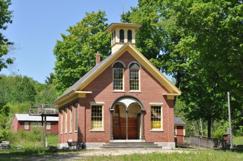


 1910
 c. 1910
 1912
 Date?
 Date?
 2024
 2018
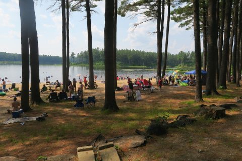 2018
 2017
 2012
 2012
 2012
 2012
 2012


