Guest, Sign inJoin

Post to Hart's Location

We’ll email a one-tap link to publish your post. No password, and nothing is public until you click it.
Already a member? Sign in
–Not graded
History · Hart's Location

Hart's Location dates to 1795

Most of Hart's Location was built recently: 0.0% of its homes predate 1940 and the median home dates from 1974. Below: 12 old photos and papers, maps from 1895 on, and the census since 1870.

1795founded
0on the National Register
0.0%homes built before 1940
12old photos & papers
From Hart's Location’s archive · credits on each photo
Quick answers

How Hart's Location began

When was Hart's Location founded?

1795

Hart's Location dates its founding to 1795 (Wikipedia’s history). The census first counted it in 1870.

First census: 26 in 18702020 census: 68231 years
Founding year: Wikipedia. First post office: 1837.The full story ↓

What stands out about Hart's Location’s past

Read from the archive, the National Register and the record. The page puts what stands out first.

★ What stands out · People over time

Hart's Location, census by census

010020018801900192019401960198020002020187 in 1890Low: 7

Lost two-thirds of its people between 1890 and 1960, then grew 9-fold.

16 censuses, 1870–2020.

U.S. Census Bureau decennial counts, from the census table on Hart's Location’s Wikipedia page.

On the map

Hart's Location on the map, 1895 to 1950

Every edition of the U.S. Geological Survey’s map of Hart's Location. Tap a year, or press play to watch the town change.

Hart's Location on the 1895 USGS mapHart's Location on the 1946 USGS mapHart's Location on the 1950 USGS map1895Crawford Notch sheet · 1:62,500

U.S. Geological Survey historical topographic maps (public domain), via Esri’s collection of the scans. The red ring marks the center of Hart's Location.

By decade

Hart's Location, decade by decade

2 decades in the archive, from the 1850s to the 1870s. Scroll each row; tap a photo for its story.

The story

How Hart's Location came to be

From Wikipedia’s history of Hart's Location.

Read it all →

Hart's Location was named after Colonel John Hart of Portsmouth, New Hampshire. In 1772, the land was granted to Thomas Chadbourne, also of Portsmouth. Native Americans used a trail up the Saco River valley through Crawford Notch, and during the French and Indian Wars, many English captives were taken to Canada that way. Despite this, the pass through the White Mountains was otherwise unknown until 1771, when Timothy Nash discovered it hunting moose, and told Governor John Wentworth.

Text from Wikipedia, licensed CC BY-SA 4.0.

From the old history books

What they wrote about Hart's Location in 1889

Passages that mention Hart's Location, cut from the printed page as they were published.

Town of Hart's Location. 943 the trestle look up a! the high cliffs and down into the Saco valley. Now we go higher above the tops of the trees. Many m picturesque mountain beighl can be Been. We cross Brook Kedron, and soon, far below, we perceive the Willej House, and the true Notch is entered, w…
History of Carroll County, New Hampshire1889 · page 943Read the page →
Read the text

Town of Hart's Location. 943 the trestle look up a! the high cliffs and down into the Saco valley. Now we go higher above the tops of the trees. Many m picturesque mountain beighl can be Been. We cross Brook Kedron, and soon, far below, we perceive the Willej House, and the true Notch is entered, with Mount \\ Illard's purple cliffs in Eronl and Mount Webster on the right . Below . the dark waters of Dismal pool are seen. The vallej grows narrower and narrower until al la-t the Qateof the Notch is reached and the ''Great Cut,'' where the railroad splits the mountains, and we arc at the < raw Cord House.

Text read by machine from the scan; it may contain errors.

Scans and text from the Internet Archive. Books published in 1930 or earlier, which are in the public domain.

Timeline

Hart's Location, 1795 to 1974

Woven from the archive, old maps, post office records, the National Register and the people born here.

  1. 18th century
  2. 1795
    FoundingHart's Location is established
  3. 19th century
  4. 1837Post officeThe Hart's Location post office opens
  5. 1857Post officeThe Hart's Location post office closes
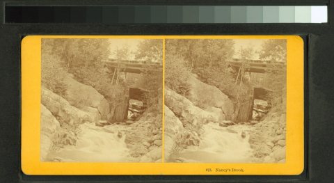
  6. 1858In the archiveNancy's Brook and Bridge, White Mountains
  7. 1872In the archiveGates of Crawford Notch and P. & O.R.R
  8. 1890CensusPopulation peaks at 187
  9. 1895On the mapFirst mapped by the U.S. Geological Survey
  10. 20th century
  11. 1937Post officeThe Willey House post office opens
  12. 1974Post officeThe Willey House post office closes
Then & now

Stand where they stood

No then-and-now pairs yet. Take a photo from the same spot as an old one and they appear here side by side.

Nancy's Brook and Bridge, White Mountains
Retake this viewNancy's Brook and Bridge, White Mountains, 1858

Find the spot, match the angle, and add your photo. It becomes the first then-and-now pair on Hart's Location’s page.

Retake this view · +15
Famous people

Famous people close to Hart's Location

Nobody well known was born in Hart's Location itself, so here are the best known from just nearby.

See all →
Places that used to be

Lost post offices and old corners

Hart's Location had its own post office from 1837 to 1857. Another post office, Willey House, opened and closed inside today’s town.

Hart's Location
1837–1857
Willey House
1937–1974
18301930today
Hamlets and corners on the map
NotchlandSawyers River

US Post Offices dataset (Blevins & Helbock, CC0). Places and cemeteries from the USGS Geographic Names Information System (2021).

Help out

Finish Hart's Location’s story

Most archives stop around 1920. The photos from after that are in family albums, not libraries.

Decades since 1900 with photos
00s10s20s30s40s50s60s70s80s90s
0 of 10 decades. The empty ones are waiting for someone’s album.
Stories next door

History across the town line

Each neighbor’s History grade, on the same three inputs.

Questions about Hart's Location’s history

What year was Hart's Location founded?

In 1795, according to Wikipedia’s history of the town. Hart's Location’s post office opened in 1837, and the census of 1870 counted 26 people here.

Memory lane

What the archives can’t tell you, neighbors can.

Town Square →
Start a conversation
Sources

Where this page comes from

Founding dates: Wikidata, Wikipedia, the U.S. post office records of Blevins & Helbock (CC0) and the Census. Homes by year built: Census ACS 2020–24. National Register of Historic Places: National Park Service (list of May 22, 2026). Old photos, postcards and papers: Wikimedia Commons, the Library of Congress and other public archives, credited on each item’s page. Maps: U.S. Geological Survey historical topographic maps (via Esri) and Sanborn fire-insurance maps (Library of Congress). History text and census tables: Wikipedia (CC BY-SA 4.0). Places that used to be: USGS Geographic Names Information System (2021). How TownRatings grades history →

From Wikimedia Commons (12), Wikipedia, U.S. Geological Survey historical maps, U.S. Census counts (via Wikipedia), the US Post Offices dataset (Blevins & Helbock), the USGS Geographic Names Information System and old county and town histories (Internet Archive). Archive images are copied here with their credits and licenses, shown on each photo’s page. Refreshed monthly.