Founding year: Wikidata. First post office: 1809.The full story ↓
History grade
What drives Colebrook’s History grade
On its age, its old homes and the National Register, Colebrook is more historic than 89% of U.S. towns. All 3 inputs are above most U.S. towns; its share of homes from before 1940 ranks highest and its National Register listings lowest.
A
HistoryA character grade: shown, never part of Colebrook’s overall grade.
New Hampshire towns list more on the Register than most of the country (a typical New Hampshire town has 9.5 per 10,000 residents, the U.S. 2.4), so Colebrook’s 20.1 sits near the middle of its state (63% of New Hampshire towns have fewer) while its 4 historic buildings outnumber those of 68% of U.S. towns.
How sure. Graded on any two of the three inputs instead, the letter would range from A− to A. The pre-1940 share is a Census survey estimate (±8.5 points). Two sources give 1796.
Founding year: Wikidata (other dates in Quick answers). Homes: Census ACS 2020–24. National Register: National Park Service, May 2026 list; each listing counted once (boundary changes and added documentation belong to their listing), and a historic district counts its contributing buildings. How TownRatings grades history →
What stands out about Colebrook’s past
Read from the archive, the National Register and the record. The page puts what stands out first.
Fire insurance maps drew every building, what it was made of and what it was used for, so insurers could price the risk of fire. Pick a year, then a sheet.
1887Sheet 1 of 1
Edition
Sheets
BrickWoodStone
Sanborn Map Company, via the Library of Congress. Editions published in 1930 or earlier, which are in the public domain.
Places that used to be
Lost post offices, old corners, places now gone and burying grounds
Colebrook’s post office has been open since 1811. Two other post offices opened and closed inside today’s town.
Cockburn
1809–1816
Colebrook
1811–today
Mohawk
1897–1903
18001910today
Hamlets and corners on the map
KiddervilleUpper Kidderville
Gone or out of use
East Colebrook ChurchchurchFactory SchoolschoolForbes SchoolschoolHarvey Swell SchoolschoolPiper SchoolschoolWhittemore Schoolschool
1cemetery inside Colebrook
Village
US Post Offices dataset (Blevins & Helbock, CC0). Places and cemeteries from the USGS Geographic Names Information System (2021).
Timeline
Colebrook, 1796 to 1930
Woven from the archive, old maps, post office records, the National Register and the people born here.
First granted in 1762 by New Hampshire's colonial Governor Benning Wentworth, the territory was named "Dryden", after English poet and playwright John Dryden. Due to the inability of its original grantees to settle the remote area, however, it was regranted in 1770 by Colonial Governor John Wentworth, who renamed it "Colebrook Town" after Sir George Colebrooke, the East India Company's chairman of the board. It was settled that same year by a single family by the name of Rosebrook, but the family was driven out by the Revolutionary War, and further settlement did not occur until after the war's end. The 1790 census recorded a population of 29, and the town was incorporated as Colebrook on June 11, 1796. For many years, it was the shire town of the Northern Judicial District of Coos County. Today, it has a district branch of the Lancaster Superior Court.
Nothing in the archives for these yearsWeddings on Main Street, storms, parades, school pictures, the old store. If it’s in your family album, it belongs here.
In 1796, according to Wikidata. Colebrook’s post office opened in 1809, and the first U.S. census counted 29 people here in 1790.
How does Colebrook rank for history?
Colebrook is more historic than 89% of U.S. towns. The History grade combines the town’s founding era, the share of homes built before 1940 and its National Register listings. It’s a character grade, so it isn’t part of the overall grade. How it works.
What is on the National Register in Colebrook?
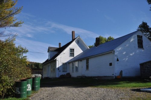
One place: the Benjamin Aldrich Homestead (listed 2003).
How old are the homes in Colebrook?
33% of Colebrook’s homes were built before 1940 (Census estimate, ±8.5 points), against a typical 17% for a New Hampshire town; the median home was built in 1973.
Founding dates: Wikidata, Wikipedia, the U.S. post office records of Blevins & Helbock (CC0) and the Census. Homes by year built: Census ACS 2020–24. National Register of Historic Places: National Park Service (list of May 22, 2026). Old photos, postcards and papers: Wikimedia Commons, the Library of Congress and other public archives, credited on each item’s page. Maps: U.S. Geological Survey historical topographic maps (via Esri) and Sanborn fire-insurance maps (Library of Congress). History text and census tables: Wikipedia (CC BY-SA 4.0). Places that used to be: USGS Geographic Names Information System (2021).
From Wikimedia Commons (21), the Library of Congress (3), the National Register of Historic Places (1), Wikipedia, Wikidata and Wikipedia for famous people, U.S. Geological Survey historical maps, U.S. Census counts (via Wikipedia), the US Post Offices dataset (Blevins & Helbock), the USGS Geographic Names Information System and Sanborn fire insurance maps (Library of Congress). Archive images are copied here with their credits and licenses, shown on each photo’s page. Refreshed monthly.




 Date?
 Date?
 Date?
 Date?
 Date?
 Date?
 2026
 2026
 2025
 2017
 2017
 2016
 2015
 2013
 2013
 2013
 2013
 2013
 2013
 2012
 2009
 2006