Guest, Sign inJoin

Post to Brentwood

We’ll email a one-tap link to publish your post. No password, and nothing is public until you click it.
Already a member? Sign in
Mary E Bartlett Library, Brentwood NHPhoto: John Phelan · CC BY-SA 3.0
BHistory
History · Brentwood

Brentwood dates to 1742, and 14% of its homes were built before 1940

More historic than 61% of U.S. towns · #97 of 126 in New Hampshire. What drives it

Below: 1 old photo or paper, maps from 1935 on, and the census since 1790.

1742founded
0on the National Register
14%homes built before 1940
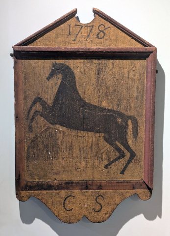
1old photo or paper
4famous people
From Brentwood’s archive · credits on each photo
Quick answers

How Brentwood began

When was Brentwood founded?

1742

Brentwood dates its founding to 1742 (Wikidata). It appears in the first U.S. census, 1790.

First census: 976 in 17902020 census: 4,490284 years

How historic is Brentwood?

B

More historic than 61% of U.S. towns, on its age, its old homes and the National Register.

What drives the grade ↓
Founding year: Wikidata. First post office: 1815.The full story ↓
History grade

What drives Brentwood’s History grade

On its age, its old homes and the National Register, Brentwood is more historic than 61% of U.S. towns, #97 of 126 in New Hampshire. Its age holds the grade up; its National Register listings pull it down.

B
HistoryA character grade: shown, never part of Brentwood’s overall grade.
All U.S. towns we grade (21,289)Ahead of 61%
NewerOlder
New Hampshire towns of 2,500+ (126)Ahead of 23%

New Hampshire towns list more on the Register than most of the country (a typical New Hampshire town has 9.5 per 10,000 residents, the U.S. 2.4), so Brentwood’s 0.0 sits below most of its state (8% of New Hampshire towns have fewer) while its 0 listings outnumber those of 23% of U.S. towns.

NoteThe founding year comes from Wikidata alone; no second source gives 1742.
How sure. Graded on any two of the three inputs instead, the letter would range from C to A−. The pre-1940 share is a Census survey estimate (±5.0 points).

Founding year: Wikidata (other dates in Quick answers). Homes: Census ACS 2020–24. National Register: National Park Service, May 2026 list; each listing counted once (boundary changes and added documentation belong to their listing), and a historic district counts its contributing buildings. How TownRatings grades history →

What stands out about Brentwood’s past

Read from the archive, the National Register and the record. The page puts what stands out first.

★ What stands out · Help out

Start Brentwood’s collection

The first neighbors to add old photos shape how Brentwood’s history is told.

Decades since 1900 with photos
00s10s20s30s40s50s60s70s80s90s
0 of 10 decades. The empty ones are waiting for someone’s album.
People over time

Brentwood, census by census

05001,0001,5002,0002,5003,0003,5004,0004,5005,00018001850190019502000999 in 1880Low: 685

Lost a third of its people between 1880 and 1920, then grew 6-fold.

24 censuses, 1790–2020.

U.S. Census Bureau decennial counts, from the census table on Brentwood’s Wikipedia page.

Timeline

Brentwood, 1742 to 2020

Woven from the archive, old maps, post office records, the National Register and the people born here.

  1. 18th century
  2. 1742
    FoundingBrentwood is established
  3. 19th century
  4. 1803Born hereMoses Fellows is born here
  5. 1806Born hereFrancis Ormand Jonathan Smith is born here
  6. 1815Post officeThe Brentwood post office opens
  7. 1835Born hereWheelock G. Veazey is born here
  8. 1872Born hereJ. W. H. Pollard is born here
  9. 1882Post officeThe Brentwood Corner post office opens
  10. 1884In the archiveAn archive photo
  11. 20th century
  12. 1903Post officeThe Brentwood Corner post office closes
  13. 1918Post officeThe Brentwood post office closes
  14. 1935On the mapFirst mapped by the U.S. Geological Survey
  15. 21st century
  16. 2020CensusPopulation peaks at 4,490
The story

How Brentwood came to be

From Wikipedia’s history of Brentwood.

Read it all →

An Abenaki tribe called the Pennacook farmed, fished and hunted in what is now Brentwood. Two main foot trails ran through the town, one along the Exeter River, where arrowheads and other stone and wooden artifacts have been found. At Pickpocket Dam, this pathway joined with the Pentucket Trail leading south to Pentucket (now Haverhill, Massachusetts) and north further into Pennacook territory.

The first non-native settlers came in 1652 to start a sawmill powered by a waterfall on the Exeter River.

Text from Wikipedia, licensed CC BY-SA 4.0.

By decade

Brentwood, decade by decade

One decade in the archive so far: the 1880s. Scroll each row; tap a photo for its story.

1890s–1990snothing yet
Nothing in the archives for these yearsWeddings on Main Street, storms, parades, school pictures, the old store. If it’s in your family album, it belongs here.
Add from your album
On the map

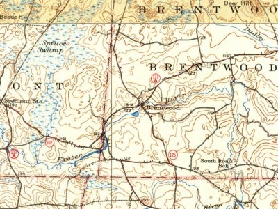
Brentwood on the map, 1935 to 1981

Every edition of the U.S. Geological Survey’s map of Brentwood. Tap a year, or press play to watch the town change.

Brentwood on the 1935 USGS mapBrentwood on the 1956 USGS mapBrentwood on the 1981 USGS map1935Hampstead sheet · 1:62,500

U.S. Geological Survey historical topographic maps (public domain), via Esri’s collection of the scans. The red ring marks the center of Brentwood.

Then & now

Stand where they stood

No then-and-now pairs yet. Take a photo from the same spot as an old one and they appear here side by side.

An archive photo
Retake this viewAn archive photo, c. 1884

Find the spot, match the angle, and add your photo. It becomes the first then-and-now pair on Brentwood’s page.

Retake this view · +15
Famous people

4 famous people were born in Brentwood

Writers, athletes, leaders and more, ranked by how widely they’re known.

See all →
Places that used to be

Lost post offices, old corners and burying grounds

Brentwood had its own post office from 1815 to 1918. Another post office, Brentwood Corner, opened and closed inside today’s town.

Brentwood
1815–1918
Brentwood Corner
1882–1903
18101920today
Hamlets and corners on the map
Brentwood CornersMarshall Corner
4cemeteries and burying grounds inside Brentwood
BrentwoodDudleySanbornWadleigh

US Post Offices dataset (Blevins & Helbock, CC0). Places and cemeteries from the USGS Geographic Names Information System (2021).

Stories next door

History across the town line

Each neighbor’s History grade, on the same three inputs.

Questions about Brentwood’s history

What year was Brentwood founded?

In 1742, according to Wikidata. Brentwood’s post office opened in 1815, and the first U.S. census counted 976 people here in 1790.

How does Brentwood rank for history?

Brentwood is more historic than 61% of U.S. towns, #97 of 126 in New Hampshire. The History grade combines the town’s founding era, the share of homes built before 1940 and its National Register listings. It’s a character grade, so it isn’t part of the overall grade. How it works.

How old are the homes in Brentwood?

14% of Brentwood’s homes were built before 1940 (Census estimate, ±5.0 points), against a typical 17% for a New Hampshire town; the median home was built in 1995.

Memory lane

What the archives can’t tell you, neighbors can.

Town Square →
Start a conversation
Sources

Where this page comes from

Founding dates: Wikidata, Wikipedia, the U.S. post office records of Blevins & Helbock (CC0) and the Census. Homes by year built: Census ACS 2020–24. National Register of Historic Places: National Park Service (list of May 22, 2026). Old photos, postcards and papers: Wikimedia Commons, the Library of Congress and other public archives, credited on each item’s page. Maps: U.S. Geological Survey historical topographic maps (via Esri) and Sanborn fire-insurance maps (Library of Congress). History text and census tables: Wikipedia (CC BY-SA 4.0). Places that used to be: USGS Geographic Names Information System (2021).

From Wikimedia Commons (6), Wikipedia, Wikidata and Wikipedia for famous people, U.S. Geological Survey historical maps, U.S. Census counts (via Wikipedia), the US Post Offices dataset (Blevins & Helbock) and the USGS Geographic Names Information System. Archive images are copied here with their credits and licenses, shown on each photo’s page. Refreshed monthly.