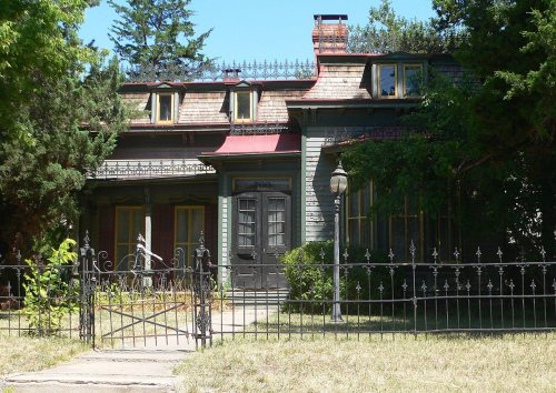
Lincoln has 104 places on the National Register, 2 of them National Historic Landmarks
More historic than 70% of U.S. towns · #20 of 57 in Nebraska. What drives it
Dated to 1856 (Wikidata and Wikipedia’s history), with 12% of its homes built before 1940 and 12 historic districts holding 3,967 contributing buildings. Below: maps from 1886 on, the census since 1870, and every listing on the Register.
Founding year: Wikidata; Wikipedia’s history section gives the same year. First post office: 1859.The full story ↓
History grade
What drives Lincoln’s History grade
On its age, its old homes and the National Register, Lincoln is more historic than 70% of U.S. towns, #20 of 57 in Nebraska. Its National Register listings hold the grade up; its age pulls it down.
B+
HistoryA character grade: shown, never part of Lincoln’s overall grade.
Among the 400 U.S. cities of 100,000 or more, Lincoln ranks #173 on History.
Nebraska towns list more on the Register than most of the country (a typical Nebraska town has 16.3 per 10,000 residents, the U.S. 2.4), so Lincoln’s 135 sits above most of its state (89% of Nebraska towns have fewer) while its 3,967 historic buildings outnumber those of 100% of U.S. towns.
How sure. Graded on any two of the three inputs instead, the letter would range from C+ to A−. The pre-1940 share (±0.6 points) is firm at this size. Two sources give 1856.
Founding year: Wikidata (other dates in Quick answers). Homes: Census ACS 2020–24. National Register: National Park Service, May 2026 list; each listing counted once (boundary changes and added documentation belong to their listing), and a historic district counts its contributing buildings. How TownRatings grades history →
What stands out about Lincoln’s past
Read from the archive, the National Register and the record. The page puts what stands out first.
National Park Service, National Register of Historic Places. Photos from Wikimedia Commons, credited on each place’s page.
Places that used to be
Lost post offices, old corners, places now gone and burying grounds
Lincoln’s post office has been open since 1868. 13 other post offices opened and closed inside today’s town.
Lancaster
1859–1868
Lincoln
1868–today
Stevens Creek
1868–1887
Park
1870–1873
State Penetentiary
1879–1880
Noblesville
1880–1887
Hyersville
1887–1889
West Lincoln
1888–1901
Athens
1889–1889
Lancaster
1889–1910
18501940today
Hamlets and corners on the map
BelmontBethanyCenter Court Mobile Home ParkCollege ViewContempo-Lincoln Mobile Home ParkCountryside EstatesGaslight VillageHarbour West Mobile Home ParkHavelockHuskervilleMark IV EstatesPine Acre Mobile Home ParkPine LakeShady Elm Mobile Home ParkShamrock Mobile Home CourtUniversity PlaceWest LincolnWest O Trailer ParkWoodlawn Estates
Gone or out of use
Bethany Post Officepost officeCollege View Post Officepost officeHyersville Post Officepost officeLancaster Post Officepost officeLincoln Air Force BasemilitaryNormal Post Officepost officeProvidence HospitalhospitalUniversity Place Post Officepost officeWest Lincoln Post Officepost officeWest OaklocaleWorthington Military Academyschool
8cemeteries and burying grounds inside Lincoln
CalvaryCheneyCollege ViewFairviewLincoln Memorial ParkMount CarmelSimmons - SaltilloWyuka
US Post Offices dataset (Blevins & Helbock, CC0). Places and cemeteries from the USGS Geographic Names Information System (2021).
Before the expansion westward of settlers, the prairie was covered with buffalo grass. Plains Indians, descendants of indigenous peoples who occupied the area for thousands of years, lived in and hunted along Salt Creek. The Pawnee, who included four tribes, lived in villages along the Platte River. The Great Sioux Nation, including the Ihanktonwan and the Lakota, to the north and west, used Nebraska as a hunting and skirmish ground, but did not have any long-term settlements in the state. An occasional buffalo could still be seen in the plat of Lincoln in the 1860s.
raids, which extended from 1873 to 1876. During the visit of these pests was the dismal period of Lincoln's history. Property fell to ruinously low prices, farmers had little to buy with, and hundreds not only left their farms, but the town of Lincoln also. But the more courageous of the people remained through the days of the scourge, and were Avell rewarded for their resolution. It was during the year 1873-74 that ]\Ir. George B. Skinner was elected Street Commissioner for the purpose of giving a large number of men work to keep them
Text read by machine from the scan; it may contain errors.
With all these reasons for encouragement, Lincoln enjoyed a lavorable growth during 1869. In reviewing the progress of the town early in 1870, Mr. Ames sums up the results as follows, in the work just quoted: "Only about two and one-half years have elapsed since the Commissioners, by official proclamation, called the town of Lincoln into existence. The village of Lancaster, which was included within its site, contained in all less than a half dozen l)uilding8 of every description. At the present time that number has been increased
Text read by machine from the scan; it may contain errors.
History of Seward county, Nebraska, together with a chapter of reminiscenses of the early settlement of Lancaster county1888 · page 142Read the page →
Read the text
The precinct, as first organized, comprised township 12 in ranges 1 and 2, and the west half of range 3 east of the (jth principal meridian, being six miles wide by fifteen long, and was known as ''Lincoln creek, or Plum creek, precinct." The first settlement was made along the Blue river, about 1864 or 1865, John and Thomas Shields, Robert McCrossou, and George Read being among, if not the first settlers.
Text read by machine from the scan; it may contain errors.
Scans and text from the Internet Archive. Books published in 1930 or earlier, which are in the public domain.
Timeline
Lincoln, 1856 to 1992
Woven from the archive, old maps, post office records, the National Register and the people born here.
Every edition of the U.S. Geological Survey’s map of Lincoln. Tap a year, or press play to watch the town change.
1964Lincoln sheet · 1:24,000
U.S. Geological Survey historical topographic maps (public domain), via Esri’s collection of the scans. The red ring marks the center of Lincoln.
Every building
Lincoln, building by building, 1886–1903
Fire insurance maps drew every building, what it was made of and what it was used for, so insurers could price the risk of fire. Pick a year, then a sheet.
In 1856, according to Wikidata and Wikipedia’s history of the town. Lincoln’s post office opened in 1859, and the census of 1870 counted 2,441 people here.
How does Lincoln rank for history?
Lincoln is more historic than 70% of U.S. towns, #20 of 57 in Nebraska. The History grade combines the town’s founding era, the share of homes built before 1940 and its National Register listings. It’s a character grade, so it isn’t part of the overall grade. How it works.
What is on the National Register in Lincoln?
104 listings, 2 of them National Historic Landmarks: 87 buildings, among them the Fairview (a National Historic Landmark since 1963), 12 historic districts with 3,839 contributing buildings, 1 site, 3 structures, and 1 object. 3,967 historic buildings in all.
How old are the homes in Lincoln?
12% of Lincoln’s homes were built before 1940 (Census estimate), against a typical 18% for a Nebraska town; the median home was built in 1982.
Founding dates: Wikidata, Wikipedia, the U.S. post office records of Blevins & Helbock (CC0) and the Census. Homes by year built: Census ACS 2020–24. National Register of Historic Places: National Park Service (list of May 22, 2026). Old photos, postcards and papers: Wikimedia Commons, the Library of Congress and other public archives, credited on each item’s page. Maps: U.S. Geological Survey historical topographic maps (via Esri) and Sanborn fire-insurance maps (Library of Congress). History text and census tables: Wikipedia (CC BY-SA 4.0). Places that used to be: USGS Geographic Names Information System (2021).
From Wikidata (24), the National Register of Historic Places (104), Wikipedia, Wikidata and Wikipedia for famous people, U.S. Geological Survey historical maps, U.S. Census counts (via Wikipedia), the US Post Offices dataset (Blevins & Helbock), the USGS Geographic Names Information System, Sanborn fire insurance maps (Library of Congress) and old county and town histories (Internet Archive). Archive images are copied here with their credits and licenses, shown on each photo’s page. Refreshed monthly.


 ★ Landmark
 ★ Landmark