High Point dates to 1750, and 34 of its places are on the National Register
More historic than 87% of U.S. towns · #24 of 290 in North Carolina. What drives it
Most of High Point was built recently: 8% of its homes predate 1940 and the median home dates from 1989. 34 places in town are on the National Register, among them eight historic districts with 1,184 buildings between them. Below: 10 old photos and papers, maps from 1885 on, and the census since 1880.
Founding year: Wikipedia. First post office: 1828.The full story ↓
History grade
What drives High Point’s History grade
On its age, its old homes and the National Register, High Point is more historic than 87% of U.S. towns, #24 of 290 in North Carolina. Its age holds the grade up; its share of homes from before 1940 pulls it down.
A
HistoryA character grade: shown, never part of High Point’s overall grade.
Among the 400 U.S. cities of 100,000 or more, High Point ranks #86 on History.
North Carolina towns list more on the Register than most of the country (a typical North Carolina town has 12.5 per 10,000 residents, the U.S. 2.4), so High Point’s 105 sits above most of its state (75% of North Carolina towns have fewer) while its 1,226 historic buildings outnumber those of 99% of U.S. towns.
NoteThe founding year comes from Wikipedia alone; no second source gives 1750.
How sure. Graded on any two of the three inputs instead, the letter would range from B+ to A+. The pre-1940 share (±1.1 points) is firm at this size.
Founding year: Wikipedia (other dates in Quick answers). Homes: Census ACS 2020–24. National Register: National Park Service, May 2026 list; each listing counted once (boundary changes and added documentation belong to their listing), and a historic district counts its contributing buildings. How TownRatings grades history →
What stands out about High Point’s past
Read from the archive, the National Register and the record. The page puts what stands out first.
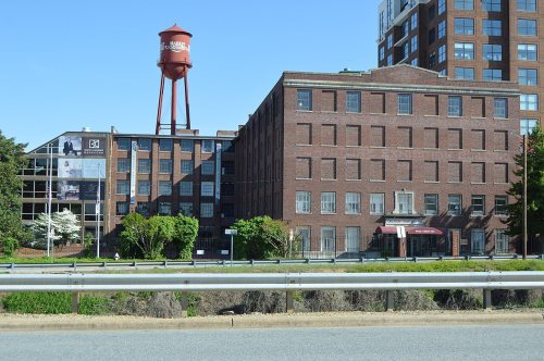
High Point was at the highest point of the 1856 North Carolina Railroad between Charlotte and Goldsboro, where it intersected the 1852 Great Western Plank Road. Its central location and transportation allowed for the delivery of raw materials like cotton and lumber as well as import and export of processed goods, contributing to its early growth. High Point was settled by Europeans, including English Quakers and German immigrants, before 1750, but was not incorporated until 1859. Before it became a major manufacturing center, the most important industries were tobacco, woodworking and textiles. The High Point furniture factory opened in 1889. High Point College was founded in 1924 as a private Methodist-affiliated institution. The college later became a liberal arts university, now with approximately 4,400 undergraduate and graduate students from 51 countries and 46 states.
An index to the enormous business done in High Point in the manufacturing business can be found by a reference to the railroad business done at this station. The amount of freight tonnage to and from High Point annually, is something enormous. The forests of this and other States have been brought under tribute to supply the millions of feet of hard and soft lumber. It is not too low an estimate to say that the annual freight bill o,i High Point has gone beyond the one million dollar mark. Thousands
Text read by machine from the scan; it may contain errors.
An institution that has made High Point famous as a furniture manufacturing center all over the United States and around the world. Started in April, 1901, it has made not only the furniture factories of High Point, but those in the entire South and Southwest known to the trade in all parts of the country. It is one of High Point's leading institutions and it would be difficult to select any concern which has been as beneficial to the furniture manufacturing industry of the town and of the South, as has been
Text read by machine from the scan; it may contain errors.
Scans and text from the Internet Archive. Books published in 1930 or earlier, which are in the public domain.
Timeline
High Point, 1750 to 1994
Woven from the archive, old maps, post office records, the National Register and the people born here.
Nothing in the archives for these yearsWeddings on Main Street, storms, parades, school pictures, the old store. If it’s in your family album, it belongs here.
Every edition of the U.S. Geological Survey’s map of High Point. Tap a year, or press play to watch the town change.
1949High Point West sheet · 1:24,000
U.S. Geological Survey historical topographic maps (public domain), via Esri’s collection of the scans. The red ring marks the center of High Point.
Every building
High Point, building by building, 1885–1917
Fire insurance maps drew every building, what it was made of and what it was used for, so insurers could price the risk of fire. Pick a year, then a sheet.
In 1750, according to Wikipedia’s history of the town. High Point’s post office opened in 1828, and the census of 1880 counted 991 people here.
How does High Point rank for history?
High Point is more historic than 87% of U.S. towns, #24 of 290 in North Carolina. The History grade combines the town’s founding era, the share of homes built before 1940 and its National Register listings. It’s a character grade, so it isn’t part of the overall grade. How it works.
What is on the National Register in High Point?
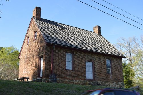
34 listings: 25 buildings, among them the John Haley House (listed 1971, the first), 8 historic districts with 1,184 contributing buildings, and 1 site. 1,226 historic buildings in all.
How old are the homes in High Point?
8% of High Point’s homes were built before 1940 (Census estimate, ±1.1 points), against a typical 4.1% for a North Carolina town; the median home was built in 1989.
Founding dates: Wikidata, Wikipedia, the U.S. post office records of Blevins & Helbock (CC0) and the Census. Homes by year built: Census ACS 2020–24. National Register of Historic Places: National Park Service (list of May 22, 2026). Old photos, postcards and papers: Wikimedia Commons, the Library of Congress and other public archives, credited on each item’s page. Maps: U.S. Geological Survey historical topographic maps (via Esri) and Sanborn fire-insurance maps (Library of Congress). History text and census tables: Wikipedia (CC BY-SA 4.0). Places that used to be: USGS Geographic Names Information System (2021).
From Wikimedia Commons (5), the Library of Congress (5), Wikidata (2), the National Register of Historic Places (34), Wikipedia, Wikidata and Wikipedia for famous people, U.S. Geological Survey historical maps, U.S. Census counts (via Wikipedia), the US Post Offices dataset (Blevins & Helbock), the USGS Geographic Names Information System, Sanborn fire insurance maps (Library of Congress) and old county and town histories (Internet Archive). Archive images are copied here with their credits and licenses, shown on each photo’s page. Refreshed monthly.






 1912
 1912
 1912
 1912
 1912
 1912
 1912
 1912


