Guest, Sign inJoin

Post to Greensboro

We’ll email a one-tap link to publish your post. No password, and nothing is public until you click it.
Already a member? Sign in
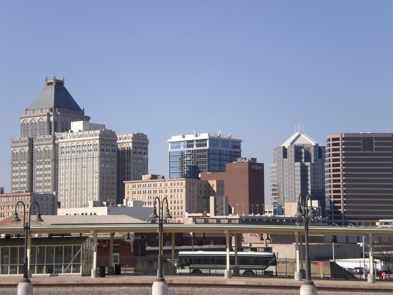
Greensboro SkylinePhoto: Beyonce245 of English Wikipedia. · Public domain
AOutdoors
Outdoors in Greensboro

13% of Greensboro’s land is conserved: 11,588 acres

The biggest trail networks: Lake Brandt Open Space & Hiking Trai (6 mi), Country Park (3.8 mi), Bur-Mill Park (2 mi). 10,518 acres are parks and preserves, 35 per 1,000 residents. 89% of residents live within a half mile of a park.

Ahead of 86% of U.S. towns · #16 of 290 in North Carolina. What drives it

Conserved land
13%
11,588 acres · of 134.7 sq mi of land
Trails
73 mi
0.5 per sq mi of land
Park land
10,518 ac
35 acres per 1,000 residents
Near a park
89%
of residents within ½ mile
Bike routes
96 mi
58 mi lanes · 32 mi paths
Lakes & rivers
32
1 beach · 4 boat launches

What kind of outdoors town is Greensboro?

Read from the map. The page puts what stands out first.

Outdoors grade

How much outdoors does Greensboro have?

On conserved land, trails, park land and how close residents live to a park, Greensboro is ahead of 86% of U.S. towns, #16 of 290 in North Carolina. All four inputs are above most U.S. towns; conserved land ranks highest, trail miles lowest.

A
OutdoorsA character grade: shown, never part of Greensboro’s overall grade.
All U.S. towns we grade (21,298)Ahead of 86%
LessMore
North Carolina towns of 2,500+ (290)Ahead of 95%

Among the 400 U.S. cities of 100,000 or more, Greensboro ranks #121 on Outdoors.

How sure. Graded on any three of the four inputs instead, the letter would range from A− to A. Trails and many small parks come from OpenStreetMap, mapped by volunteers, so coverage varies from town to town; the half mile is a straight line from each census block, so a river or highway in the way isn’t counted against it.

PAD-US, OpenStreetMap (© OpenStreetMap contributors), Census 2025 Gazetteer and 2020 blocks; details in Sources below. How TownRatings grades the outdoors →

The map

Conserved land, trails & bike routes

Tap a number to zoom to a park. Tap a layer to hide it.

12345678
Easements protect land from building but are usually private.© OpenStreetMap contributors · USGS PAD-US
Places to walk

Pick a walk

The longest trail network is Lake Brandt Open Space & Hiking Trai, with 6 miles. Directions go to the nearest trailhead or public parking.

Lake Brandt Open Space & Hiking Trai

Park
232 acres6 mi of trail
Wild Turkey TrailNat Greene Trail
Dog rules not recorded
Directionsto the parking lot

Bur-Mill Park

Park
250 acres2 mi of trail
Big Loop TrailOwl's Roost Trail
Dog rules not recorded
Directionsto the parking lotWebsite ↗

Bryan Park

Managed by City of Greensboro
790 acres1.9 mi of trail
Townsend Trail
Dog rules not recorded
Directionsto the parking lotWebsite ↗

Hamilton Lakes Park

Park
51 acres1.7 mi of trail
Dog rules not recorded
Directionsto the parking lot

Price Park

Park
88 acres1.4 mi of trail
Evergreen Trail
Dog rules not recorded
Directionsto the parking lotWebsite ↗

Oka T. Hester Park

Park
87 acres0.9 mi of trail
Hester Park Trail 1Hester Park Trail 4Hester Park Trail 3Hester Park Trail 2
Dog rules not recorded
Directionsto the parking lotWebsite ↗

Fisher Park

Park
16 acres0.9 mi of trail
Dog rules not recorded
Directionsto the parking lot
All 99 parks & preserves
Lake Brandt Open Space & Hiking Trai232 acres · 6 mi of trail
Directions
Country Park224 acres · 3.8 mi of trail
Directions
Bur-Mill Park250 acres · 2 mi of trail
Directions
Bryan Park790 acres · 1.9 mi of trail · City of Greensboro
Directions
Hamilton Lakes Park51 acres · 1.7 mi of trail
Directions
Price Park88 acres · 1.4 mi of trail
Directions
Oka T. Hester Park87 acres · 0.9 mi of trail
Directions
Fisher Park16 acres · 0.9 mi of trail
Directions
Gateway Gardens11 acres · 0.8 mi of trail
Directions
Peabody Park15 acres · 0.4 mi of trail
Directions
Joe Davis Park12 acres · 0.4 mi of trail
Shannon Woods Park32 acres · 0.3 mi of trail
Benjamin Park Bog Garden23 acres · 0.3 mi of trail
Directions
Guilford Courthouse National Military Park213 acres · 0.2 mi of trail · National Park Service
Directions
Barber Park118 acres · 0.2 mi of trail
Directions
Bingham Park12 acres · 0.2 mi of trail
Directions
Keeling Park5 acres · 0.2 mi of trail
Keeley Park129 acres · 0.1 mi of trail
Directions
Lake Daniel Park63 acres · 0.1 mi of trail
Directions
Market Street Park20 acres · 0.1 mi of trail
Directions
Greensboro Arboretum20 acres · 0.1 mi of trail
Directions
Cumberland Park3 acres · 0.1 mi of trail
Directions
Foust Park3 acres · 0.1 mi of trail
Directions
Cardinal Cove2 acres · 0.1 mi of trail
Directions
Ole Asheboro Park1 acres · 0.1 mi of trail · City of Greensboro
Directions
Rosewood Park1 acres · 0.1 mi of trail
Latham Park71 acres
Directions
Jaycee Park35 acres
Directions
Starmount Park35 acres
Directions
Hillsdale Park30 acres
Directions
Lindley Park26 acres
Directions
Kings Forest20 acres
Sheridan Park19 acres
Leonard Recreation Center18 acres
Greenhaven Park18 acres
Directions
Tanger Bicentennial Gardens16 acres
Directions
Rolling Park15 acres
Directions
Shannon Hills Park15 acres
Directions
Memorial Stadium Complex14 acres
Directions
Adams Farm Park14 acres
Directions
Pinecroft Lake Park13 acres · Piedmont Land Conservancy
Directions
Brown Bark Park13 acres
Lake Daniel Reservoir Park12 acres
Directions
Hampton Park11 acres
Bluford Park11 acres
Directions
Woodlea Acres Park10 acres
Revolution Park9 acres
Directions
Hunter Hills Park9 acres
O. Henry Oaks Park8 acres
Tannenbaum Historic Park8 acres
Directions
Random Woods Park8 acres
Directions
Amber Park7 acres
Forest Valley Park7 acres
Craft Park6 acres
Britishwoods Park6 acres
Directions
Lake Townsend Park6 acres · City of Greensboro
T. Gilbert Pearson Audubon Natural Area6 acres · T. Gilbert Pearson Audubon Society
Directions
Douglas Park6 acres
Directions
Peeler Center & Park6 acres
Old Peck Ballfield6 acres
Glenwood Park5 acres
Directions
Erskine Park5 acres
Kevin Harvick Foundation Park5 acres
Directions
Dudley School Park4 acres
Directions
Smith Center & Park4 acres
Directions
Greenfield Park4 acres
Johnson Park4 acres
Rotherwood Park4 acres
Directions
Dogwood Park3 acres
College Park3 acres
Directions
Ardmore Park3 acres
Directions
Lebauer Park2 acres
Directions
Cascade Park2 acres
Directions
Spring Valley Park2 acres
Directions
Forest Hill Park2 acres
Directions
The Blandwood Gardens2 acres
Directions
Carolina Laurel Park2 acres
Oaks West Park2 acres
Sternberger Park2 acres
Directions
Kirkwood Park2 acres
Nut Bush Park2 acres
Fairview Homes Park2 acres
Directions
Nealtown Park2 acres
Elmwood Park2 acres
Zoe Barbee2 acres
Gracewood Park2 acres
Center City Park1 acres
Directions
Hood Park1 acres
Murchie Street Park1 acres
Robert F. Mayer Park1 acres
Directions
Nottingham Park1 acres
Tuscaloosa Street Tot Lot1 acres
Youth Park Plaza1 acres
Directions
Mary Lynn Richardson Park1 acres · Greensboro History Museum
Directions
Merryweather Road Park1 acres
Northside Park1 acres
Springdale Park1 acres
Directions
Pear Street Park1 acres
Tolbert Park1 acres
Directions
Who protects it

11,588 conserved acres

13% of Greensboro’s land. Who manages Greensboro’s conserved land, from the USGS Protected Areas Database. Approximate, because parcels can overlap.

Town or city3,210 ac
County3,142 ac
National Park Service224 ac
Other or Unknown Local Government81 ac
State conservation56 ac
Land trusts & nonprofits51 ac
State natural resources9 ac
Local Recreation Area · 9,261 acLocal Park · 3,545 acLocal Resource Management Area · 2,563 acLocal Other or Unknown · 1,224 acHistoric or Cultural Area · 224 ac
Good to know

Conserved doesn’t always mean open to visitors. 12 acres are conservation easements, usually private land. Public access isn’t recorded for 54 of 193 parcels. The walks above are places people visit.

The biggest protected parcels
Parcel (PAD-US)Managed byAcresPublic access
City of Greensboro Open Space
Local Other or Unknown
Not recorded8,400Unknown
Guilford County Park
Local Park
County3,133Open
City of Greensboro - Country Park
Local Recreation Area
Not recorded415Open
Lake Brandt - Owls Roost
Local Resource Management Area
Town or city391Open
Lake Brandt - Reedy Fork
Local Resource Management Area
Town or city331Open
Lake Brandt - Nat Greene
Local Resource Management Area
Town or city309Open
Lake Townsend - Townsend Dam
Local Resource Management Area
Town or city259Open
Guilford County - Bur-Mil Park
Local Recreation Area
Not recorded227Unknown
Guilford Courthouse National Military Park
Historic or Cultural Area
National Park Service224Restricted
Lake Higgins - Lewiston
Local Resource Management Area
Town or city212Open

5 smaller protected places aren’t shown.

Things to do

151 places to go in Greensboro

Beaches, playgrounds, peaks, falls and more. Pick a kind.

Playgrounds in Greensboro
Adams Farm PlaygroundIn Adams Farm Park
Directions
British Wood ParkIn Britishwoods Park
Directions
Carriage Hills Park
Directions
David Stern Play Ground
Directions
Declan’s PlaygroundIn Market Street Park
Directions
Safety TownIn Jaycee Park
Directions
Spring Valley Park
Directions
Village in the Trees
Directions
1 more playground
Woven Works ParkIn Cumberland Park
Directions

125 playgrounds are on OpenStreetMap in all; the list shows named ones from the first 30.

Trails & water

25 named trails and 32 lakes & rivers

Named trails
Open to bikes · 28.4 miUnpaved · 57.7 mi
Bald Eagle Trail4.4 mi
Owl's Roost Trail3.4 mi
Wild Turkey Trail3.4 mi
Nat Greene Trail3.3 mi
Townsend Trail3.2 mi
Reedy Fork Trail3.0 mi
Laurel Bluff Trail2.9 mi
Blue Heron Trail2.6 mi
Piedmont Trail2.6 mi
Osprey Trail2.1 mi
15 more trails
Big Loop Trail
1.9 mi
Palmetto Trail
1.8 mi
Atlantic and Yadkin Greenway
1.7 mi
Crockett Trail
1.1 mi
Evergreen Trail
0.9 mi
West House Trail
0.8 mi
Hester Park Trail 1
0.6 mi
King Fisher Trail
0.6 mi
Underground RR Tree Path
0.4 mi
Bog Garden Trail
0.2 mi
Hester Park Trail 4
0.2 mi
Nat Greene Trail Connector
0.1 mi
Hester Park Trail 3
0.1 mi
Hester Park Trail 2
0.1 mi
Watershed Connector Trail
0.1 mi
Lakes & rivers tap for directions
Biking & sports

96 miles of bike routes

Bike lanes are often missing from the map in smaller towns, so that number is likely low.

58 mi
painted or protected bike lanes
32 mi
off-road bike paths
5.7 mi
shoulders & shared lanes
Atlantic and Yadkin GreenwayBike route
1.7 mi
Courts & fields
225Tennis
67Baseball
44Basketball
35Soccer
22Pickleball
10Football
8Softball
8Beach volleyball

Includes school and college facilities, which aren’t always open to the public.

History along the way

61 places on the National Register, 2 of them National Historic Landmarks

The country’s official list of places worth saving (National Park Service). The map also marks 51 historic points from OpenStreetMap: plaques, memorials and old buildings.

History →
★
F. W. Woolworth Company BuildingNational Historic Landmark · Place
About it
★
BlandwoodNational Historic Landmark · Building · listed 1970
About it
StagvilleBuilding · listed 1973
About it
Jefferson Standard BuildingBuilding · listed 1976
About it
Bumpas-Troy HouseBuilding · listed 1977
About it
Michael Sherwood HouseBuilding · listed 1978
About it
Guilford County CourthouseBuilding · listed 1979
About it
Charles H. Ireland HouseBuilding · listed 1979
About it
Green Hill Cemetery Gatekeeper's HouseBuilding · listed 1979
About it
Wafco MillsBuilding · listed 1979
About it
HillsideBuilding · listed 1980
About it
Central Fire StationBuilding · listed 1980
About it

49 more on the History page.

When to get out

The best walking months in Greensboro: April and May

NOAA’s 1991–2020 normals for the town and the daylight at its latitude. Outlined months have long days, highs of 59 to 86 °F and little rain for the place.

JanFebMarAprMayJunJulAugSepOctNovDec
Daylight (h)10.010.811.913.114.114.614.413.512.411.210.29.7
High (°F)505461717885898781716152
Rain (in)3.62.94.03.83.74.44.24.64.43.33.33.4

February is the driest month (2.9 in) and July the warmest (highs of 89 °F). 4.6 inches fall in August, the wettest month. Summer highs reach 89 °F, too hot for the outline. The climate in Greensboro →

Next door

Greensboro and its neighbors

Greensboro has the most mapped trails of the 6 towns around it. Tap a town to see its outdoors.

TownConserved
of land
Trail mi
per sq mi
Park acres
per 1,000
Near a park
½ mile
Outdoors
Greensboro13%0.53589%A
Summerfield4%0.12634%C+
Jamestown10%1.65696%A+
High Point11%0.23275%B+
Kernersville2%0.21254%C+
Oak Ridge3%0.23228%B−

The four inputs of the Outdoors grade, from the engine; shares are of land, not water.

Questions about parks and trails in Greensboro

Where can I hike in Greensboro?

The longest trail networks: Lake Brandt Open Space & Hiking Trai, 6 miles; Country Park, 3.8 miles; Bur-Mill Park, 2 miles; Bryan Park, 1.9 miles. Each one is on the map above, with directions to the nearest trailhead or parking.

How much of Greensboro is conserved land?

13% of its land, against a typical 3% for a North Carolina town and 4% nationally (PAD-US). Conserved doesn’t always mean open to visitors: easements are usually private land.

Are dogs allowed on Greensboro’s trails?

Lake Brandt Open Space & Hiking Trai and Country Park don’t have dog rules recorded on the map; check the signs at the trailhead.

Where can I bike in Greensboro?

96 miles of bike routes are on the map: 58 of painted or protected lanes, 32 of off-road paths and 5.7 of shoulders and shared lanes. Named routes: Atlantic and Yadkin Greenway.

Is there public land near Greensboro?

24,610 acres of parks and open public land lie inside Greensboro or within 10 miles of it (PAD-US), 10,518 of them inside the city line.

How much outdoors does Greensboro have?

Ahead of 86% of U.S. towns on the Outdoors grade, #16 of 290 in North Carolina. The grade combines the share of land that is conserved, miles of mapped trail per square mile of land, park acres per 1,000 residents and the share of residents within a half mile of a park. It’s a character grade, so it isn’t part of the overall grade. How it works.

Trail talk

Conditions, parking and favorite walks from Greensboro neighbors.
Town Square →
Share a tip
Sources

Where this page comes from

Conserved and public land: USGS Protected Areas Database of the United States (PAD-US), service updated July 2026. Parks, trails, playgrounds, beaches and other places: OpenStreetMap (© OpenStreetMap contributors, ODbL), map data as of 2026-10-28. Land and water area: Census 2025 Gazetteer. Residents near a park: 2020 Census blocks. National Register: National Park Service. How TownRatings grades the outdoors →