Columbia’s post office opened in 1819, and 9 of its places are on the National Register
More historic than 84% of U.S. towns · #6 of 100 in Mississippi. What drives it
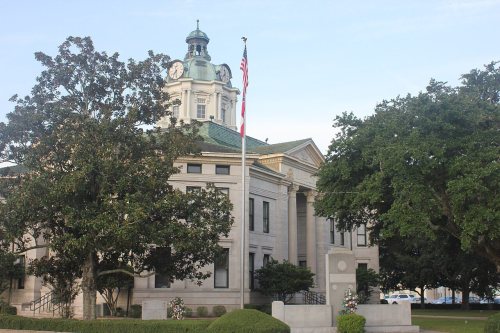
Most of Columbia was built recently: 8% of its homes predate 1940 and the median home dates from 1969. 9 places in town are on the National Register, among them five historic districts with 679 buildings between them. Below: 1 old photo or paper, maps from 1915 on, and the census since 1870.
Founding year: the first Columbia post office (Blevins & Helbock, CC0).The full story ↓
History grade
What drives Columbia’s History grade
On its age, its old homes and the National Register, Columbia is more historic than 84% of U.S. towns, #6 of 100 in Mississippi. Its National Register listings hold the grade up; its share of homes from before 1940 pulls it down.
A−
HistoryA character grade: shown, never part of Columbia’s overall grade.
Mississippi towns list more on the Register than most of the country (a typical Mississippi town has 71.9 per 10,000 residents, the U.S. 2.4), so Columbia’s 1,036 sits above most of its state (96% of Mississippi towns have fewer) while its 687 historic buildings outnumber those of 98% of U.S. towns.
How sure. Graded on any two of the three inputs instead, the letter would range from B to A+. The pre-1940 share is a Census survey estimate (±3.8 points). The founding year is the first post office, not a stated founding date.
Founding year: the first post office (other dates in Quick answers). Homes: Census ACS 2020–24. National Register: National Park Service, May 2026 list; each listing counted once (boundary changes and added documentation belong to their listing), and a historic district counts its contributing buildings. How TownRatings grades history →
What stands out about Columbia’s past
Read from the archive, the National Register and the record. The page puts what stands out first.
Columbia is the county seat of Marion County, which was created out of Amite County in 1811, encompassing the southwest quarter of the current state of Mississippi. Before statehood in 1816, there were three territorial census/poll tax records taken of what was deemed Marion County at the time. These records reveal that during 1813, several Lott men arrived and settled on the Pearl River in what is now Columbia. In 1813, William Lott was the largest slave holder near present-day Columbia, owning 28 people. Five mensettled south of present-day Columbia on 2,789 acres (1,129 ha) of land with 65 enslaved people. North of present-day Columbia, on what was the earliest attempt at a town, Timothy Terrell enslaved 32 people on 3,151 acres (1,275 ha).
Passages that mention Columbia, cut from the printed page as they were published.
Our western empire, or, The new West beyond the Mississippi [microform]1882 · page 1141Read the page →
Read the text
Hempstead to Brenham, thirty miles; the Galveston, Houston and Henderson Railroad, from Galveston to Houston, fifty miles; the Texas anu New Orleans Railroad, from Houston to Liberty, forty miles; and the Columbia and Brazos River Railroad, from Houston to Columbia, fifty miles—making a total of 330 miles of railroad in actual operation fifteen years ago. The Southern P«cific Railroad (now the Texas and Pacific) was under operation from Shreveport, La., to the Texas line, but at that period had’
Text read by machine from the scan; it may contain errors.
Our western empire, or, The new West beyond the Mississippi [microform]1882 · page 1110Read the page →
Read the text
them ; so that the railway is the only hope for cheap transportation from the Upper Columbia. The Northern Pacific will eventually construct a railway down the north bank of the Columbia, and extend it to Portland, which is not on the Columbia, but on the Willamette, one of its largest tributaries, The Willamette is navigable partly by slackwater navigation for 138 miles from its mouth, But the Willamette valley is already traversed by two railroads, and is likely ere long to be gridironed
Text read by machine from the scan; it may contain errors.
Scans and text from the Internet Archive. Books published in 1930 or earlier, which are in the public domain.
Every edition of the U.S. Geological Survey’s map of Columbia. Tap a year, or press play to watch the town change.
1970Columbia North sheet · 1:24,000
U.S. Geological Survey historical topographic maps (public domain), via Esri’s collection of the scans. The red ring marks the center of Columbia.
Every building
Columbia, building by building, 1915–1925
Fire insurance maps drew every building, what it was made of and what it was used for, so insurers could price the risk of fire. Pick a year, then a sheet.
Between 66 and 7,733 people in every census since 1870.
14 censuses, 1870–2020.
U.S. Census Bureau decennial counts, from the census table on Columbia’s Wikipedia page.
Places that used to be
Places now gone and burying grounds
Columbia’s post office has been open since 1819.
Gone or out of use
Dalys Hospitalhospital
4cemeteries and burying grounds inside Columbia
Columbia CityNorth Columbia CityPopeWoodlawn
US Post Offices dataset (Blevins & Helbock, CC0). Places and cemeteries from the USGS Geographic Names Information System (2021).
Questions about Columbia’s history
What year was Columbia founded?
The Columbia post office opened in 1819, the earliest record of the town by name (U.S. post office records).
How does Columbia rank for history?
Columbia is more historic than 84% of U.S. towns, #6 of 100 in Mississippi. The History grade combines the town’s founding era, the share of homes built before 1940 and its National Register listings. It’s a character grade, so it isn’t part of the overall grade. How it works.
What is on the National Register in Columbia?
9 listings: 4 buildings, among them the U.S. Post Office (listed 1981, the first), and 5 historic districts with 679 contributing buildings. 687 historic buildings in all.
How old are the homes in Columbia?
8% of Columbia’s homes were built before 1940 (Census estimate, ±3.8 points), against a typical 4.5% for a Mississippi town; the median home was built in 1969.
Founding dates: Wikidata, Wikipedia, the U.S. post office records of Blevins & Helbock (CC0) and the Census. Homes by year built: Census ACS 2020–24. National Register of Historic Places: National Park Service (list of May 22, 2026). Old photos, postcards and papers: Wikimedia Commons, the Library of Congress and other public archives, credited on each item’s page. Maps: U.S. Geological Survey historical topographic maps (via Esri) and Sanborn fire-insurance maps (Library of Congress). History text and census tables: Wikipedia (CC BY-SA 4.0). Places that used to be: USGS Geographic Names Information System (2021).
From Wikimedia Commons (1), the Library of Congress (1), Wikidata (3), the National Register of Historic Places (9), Wikipedia, U.S. Geological Survey historical maps, U.S. Census counts (via Wikipedia), the US Post Offices dataset (Blevins & Helbock), the USGS Geographic Names Information System, Sanborn fire insurance maps (Library of Congress) and old county and town histories (Internet Archive). Archive images are copied here with their credits and licenses, shown on each photo’s page. Refreshed monthly.




 Date?
 2010


