Guest, Sign inJoin

Post to Columbia

We’ll email a one-tap link to publish your post. No password, and nothing is public until you click it.
Already a member? Sign in
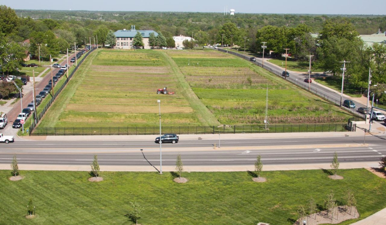
Sanborn Field and Soil Erosion PlotsSanborn Field and Soil Erosion Plots · Photo: Iwtwb8 · CC BY-SA 3.0
A−Outdoors
Outdoors in Columbia

Columbia has 92 miles of mapped trails, 1.3 for every square mile of land

The biggest trail networks: Cosmo Park (14.7 mi), Gans Creek Recreation Area (7.3 mi), Grindstone Nature Area (5 mi). 89% of residents live within a half mile of a park. 3,344 acres are parks and preserves, 26 per 1,000 residents.

Ahead of 83% of U.S. towns · #14 of 247 in Missouri. What drives it

Conserved land
4%
1,709 acres · of 67.8 sq mi of land
Trails
92 mi
1.3 per sq mi of land
Park land
3,344 ac
26 acres per 1,000 residents
Near a park
89%
of residents within ½ mile
Bike routes
148 mi
80 mi lanes · 58 mi paths
Lakes & rivers
27
4 beaches · 3 boat launches

What kind of outdoors town is Columbia?

Read from the map. The page puts what stands out first.

Outdoors grade

How much outdoors does Columbia have?

On conserved land, trails, park land and how close residents live to a park, Columbia is ahead of 83% of U.S. towns, #14 of 247 in Missouri. All four inputs are above most U.S. towns; trail miles rank highest, conserved land lowest.

A−
OutdoorsA character grade: shown, never part of Columbia’s overall grade.
All U.S. towns we grade (21,298)Ahead of 83%
LessMore
Missouri towns of 2,500+ (247)Ahead of 95%

Among the 400 U.S. cities of 100,000 or more, Columbia ranks #163 on Outdoors.

Few Missouri towns conserve much land (a typical one, 2%; the U.S., 4%), so Columbia’s 4% is ahead of 76% of Missouri towns, while its trails per square mile lead 94% of them.

How sure. Graded on any three of the four inputs instead, the letter would range from B+ to A. Trails and many small parks come from OpenStreetMap, mapped by volunteers, so coverage varies from town to town; the half mile is a straight line from each census block, so a river or highway in the way isn’t counted against it.

PAD-US, OpenStreetMap (© OpenStreetMap contributors), Census 2025 Gazetteer and 2020 blocks; details in Sources below. How TownRatings grades the outdoors →

The map

Conserved land, trails & bike routes

Tap a number to zoom to a park. Tap a layer to hide it.

12345678
Easements protect land from building but are usually private.© OpenStreetMap contributors · USGS PAD-US
Places to walk

Pick a walk

The longest trail network is Cosmo Park, with 14.7 miles. Directions go to the nearest trailhead or public parking.

Cosmo Park

Park
508 acres14.7 mi of trail
Rhett's Run TrailCosmo Park TrailOld Quarry Road Trail
Dog rules not recorded
Directionsto the parking lot

Gans Creek Recreation Area

Park
316 acres7.3 mi of trail
Discovery Ridge TrailGans Creek Cross Country Course
Dog rules not recorded
Directionsto the trailheadWebsite ↗

Grindstone Nature Area

Park
240 acres5 mi of trail
Ridgeline TrailLost Hill TrailSpring House TrailConnector Trail
Dog rules not recorded
Directionsto the trailhead

Forum Nature Area

Park
107 acres2 mi of trail
Dog rules not recorded
Directionsto the parking lot

Bonnie View Nature Sanctuary

Managed by Columbia Parks and Recreation
187 acres1.8 mi of trail
Nature TrailPrairie Education Trail
Dog rules not recorded
Directionsto the parking lot

A. Perry Philips Park

Park
133 acres1.7 mi of trail
Phillips Lake Trail
Dog rules not recorded
Directionsto the trailhead

Hinkson Woods Conservation Area

Managed by Missouri Department of Conservation
73 acres1.3 mi of trail
Hinkson Woods Conservation Area Trail
Dog rules not recorded
Directionsto the parking lot

Albert-Oakland Park

Managed by City of Columbia
79 acres1.2 mi of trail
Dog rules not recorded
Directionsto the parking lot
All 75 parks & preserves
Cosmo Park508 acres · 14.7 mi of trail
Directions
Gans Creek Recreation Area316 acres · 7.3 mi of trail
Directions
Grindstone Nature Area240 acres · 5 mi of trail
Directions
Forum Nature Area107 acres · 2 mi of trail
Directions
Bonnie View Nature Sanctuary187 acres · 1.8 mi of trail · Columbia Parks and Recreation
Directions
A. Perry Philips Park133 acres · 1.7 mi of trail
Directions
Hinkson Woods Conservation Area73 acres · 1.3 mi of trail · Missouri Department of Conservation
Directions
Albert-Oakland Park79 acres · 1.2 mi of trail · City of Columbia
Directions
Twin Lakes Recreation Area70 acres · 1.2 mi of trail
Directions
Indian Hills Park39 acres · 1.2 mi of trail
Directions
Cosmo-Bethel Park36 acres · 1.2 mi of trail · City of Columbia
Directions
Nifong Park60 acres · 1.1 mi of trail · City of Columbia
Directions
Columbia Audubon Nature Sanctuary22 acres · 1.1 mi of trail
Directions
Stephens Lake Park121 acres · 0.9 mi of trail
Directions
Kiwanis Park21 acres · 0.9 mi of trail
Directions
Norma Sutherland Smith Park49 acres · 0.8 mi of trail · City of Columbia
Directions
Clary-Shy Community Park19 acres · 0.8 mi of trail
Directions
Waters-Moss Memorial Wildlife Area113 acres · 0.7 mi of trail
Directions
Thomas E "Country" Atkins Jr. Memorial Park77 acres · 0.7 mi of trail · Columbia Parks and Recreation
Directions
C.M. Albert Memorial Park22 acres · 0.7 mi of trail · City of Columbia
Directions
Magnolia Falls Park16 acres · 0.7 mi of trail
Directions
Columbia Agriculture Park7 acres · 0.7 mi of trail · City of Columbia
Directions
Rock Quarry Park19 acres · 0.6 mi of trail
Directions
Longview Park12 acres · 0.6 mi of trail
Shelter Gardens7 acres · 0.6 mi of trail
Directions
Capen Park34 acres · 0.5 mi of trail · City of Columbia
Directions
Clyde Wilson Memorial Park11 acres · 0.5 mi of trail · City of Columbia
Directions
Louisville Park9 acres · 0.5 mi of trail
Douglass Park7 acres · 0.5 mi of trail
Directions
Fairview Park27 acres · 0.4 mi of trail
Directions
Smithton Park12 acres · 0.4 mi of trail
Oakwood Hills Park10 acres · 0.4 mi of trail
Valley View Park8 acres · 0.4 mi of trail
Directions
Martin Luther King, Jr. Memorial at Battle Garden8 acres · 0.4 mi of trail
Directions
Woodridge Park7 acres · 0.4 mi of trail
Directions
Vineyards Lake Park28 acres · 0.3 mi of trail
Directions
American Legion Park16 acres · 0.3 mi of trail · City of Columbia
Directions
Auburn Hills Park14 acres · 0.3 mi of trail · Columbia Parks and Recreation
Eastport Park12 acres · 0.3 mi of trail · Columbia Parks and Recreation
Cascades Park11 acres · 0.3 mi of trail · City of Columbia
Again Street Park10 acres · 0.3 mi of trail · City of Columbia
Directions
Highpointe Park7 acres · 0.3 mi of trail · City of Columbia
Brown Station Park5 acres · 0.3 mi of trail · City of Columbia
Peace Park4 acres · 0.3 mi of trail
Directions
Westwinds Park4 acres · 0.3 mi of trail
Francis Quadrangle3 acres · 0.3 mi of trail
Directions
Kuhlman Court3 acres · 0.3 mi of trail
Directions
Grasslands Park8 acres · 0.2 mi of trail · City of Columbia
Directions
Proctor Park6 acres · 0.2 mi of trail
Shepard Boulevard Park6 acres · 0.2 mi of trail
Smiley Lane Park6 acres · 0.2 mi of trail
Barberry Park5 acres · 0.2 mi of trail · City of Columbia
Directions
Rothwell Park5 acres · 0.2 mi of trail
McKee Street Park5 acres · 0.2 mi of trail
Lange Park3 acres · 0.2 mi of trail
Garth Nature Area52 acres · 0.1 mi of trail
Directions
MKT Scott Blvd Access15 acres · 0.1 mi of trail
Directions
Bear Creek Park11 acres · 0.1 mi of trail · City of Columbia
Dublin Park6 acres · 0.1 mi of trail · City of Columbia
Flat Branch Park4 acres · 0.1 mi of trail
Directions
Rock Bridge Park3 acres · 0.1 mi of trail · Columbia Parks and Recreation
Directions
Mel Carnahan Quadrangle2 acres · 0.1 mi of trail
Directions
Parkade Park2 acres · 0.1 mi of trail
Worley Street Park2 acres · 0.1 mi of trail
Field Park1 acres · 0.1 mi of trail
Directions
Molly Bowden Memorial Park1 acres · 0.1 mi of trail · Columbia Parks and Recreation
John W. Alspaugh Park201 acres · Columbia Parks and Recreation
Strawn Park126 acres
Directions
Battle Park31 acres · City of Columbia
Directions
3M Flat Branch-Hinkson Creek Wetlands30 acres · City of Columbia
Directions
Jay Dix Station22 acres
Directions
Lions-Stephens Park7 acres
Directions
Garden City Greenspace1 acres
Sterling W. Wyatt Park1 acres
Directions
Downtown Optimist Park1 acres
Directions
Who protects it

1,709 conserved acres

4% of Columbia’s land. Who manages Columbia’s conserved land, from the USGS Protected Areas Database. Approximate, because parcels can overlap.

Town or city1,702 ac
Not recorded6 ac
Local Park · 958 acLocal Conservation Area · 739 acState Other or Unknown · 6 acLocal Other or Unknown · 5 ac
The biggest protected parcels
Parcel (PAD-US)Managed byAcresPublic access
Gans Creek Recreation Area
Local Conservation Area
Town or city299Open
Mkt Nature And Fitness Trail
Local Conservation Area
Town or city188Open
Strawn Park
Local Park
Town or city128Open
Forum Nature Area
Local Park
Town or city105Open
Bonnie View Nature Sanctuary
Local Park
Town or city94Open
Atkins Park
Local Park
Town or city77Open
Albert-Oakland Park
Local Park
Town or city57Open
Gates Property
Local Conservation Area
Town or city56Open
Garth Nature Area
Local Park
Town or city51Open
Smith Park
Local Conservation Area
Town or city49Open

5 smaller protected places aren’t shown.

Things to do

202 places to go in Columbia

Beaches, playgrounds, peaks, falls and more. Pick a kind.

Playgrounds in Columbia
Burger King indoor playground
Directions
Eastport Park PlaygroundIn Eastport Park
Directions
Harry L. Gentry PlaygroundIn Nifong Park
Directions
Rothwell Park PlaygroundIn Rothwell Park
Directions
Steinberg PlaygroundIn Cosmo Park
Directions
Tiger Bounce
Directions
Tot LotIn Cosmo Park
Directions
Tot LotIn Worley Street Park
Directions
1 more playground
ValleyView Park PlaygroundIn Valley View Park
Directions

166 playgrounds are on OpenStreetMap in all; the list shows named ones from the first 30.

Trails & water

24 named trails and 27 lakes & rivers

Named trails
Open to bikes · 15.0 miUnpaved · 18.3 mi
Rhett's Run Trail5.3 mi
Discovery Ridge Trail4.1 mi
Gans Creek Cross Country Course2.1 mi
Phillips Lake Trail1.5 mi
Cosmo Park Trail1.2 mi
Ridgeline Trail1.1 mi
Nature Trail0.9 mi
Woodpecker Hollow Trail0.7 mi
Hinkson Woods Conservation Area Trail0.7 mi
Lost Hill Trail0.4 mi
14 more trails
Oakwood Hills Park Trail
0.4 mi
Prairie Education Trail
0.4 mi
Spur
0.4 mi
Hinkson Trail
0.3 mi
Paxton's Passage
0.3 mi
Fairview Connector
0.3 mi
Auburn Hills Trail
0.3 mi
Loop Trail
0.3 mi
Spring House Trail
0.2 mi
MKT Connector
0.2 mi
Old Quarry Road Trail
0.2 mi
Connector Trail
0.2 mi
MKT Connector Trail
0.1 mi
Woodpecker Hollow Trail Connector
0.1 mi
Lakes & rivers tap for directions
Biking & sports

148 miles of bike routes

Bike lanes are often missing from the map in smaller towns, so that number is likely low.

80 mi
painted or protected bike lanes
58 mi
off-road bike paths
9.7 mi
shoulders & shared lanes
Courts & fields
133Golf
112Basketball
90Tennis
51Baseball
42Soccer
26Pickleball
16Football
12Beach volleyball

Includes school and college facilities, which aren’t always open to the public.

History along the way

41 places on the National Register, one a National Historic Landmark

The country’s official list of places worth saving (National Park Service). The map also marks 11 historic points from OpenStreetMap: plaques, memorials and old buildings.

History →
★
Sanborn Field and Soil Erosion PlotsNational Historic Landmark · Site · listed 1966
About it
Francis Quadrangle Historic DistrictDistrict · listed 1973
About it
Sanford F. Conley HouseBuilding · listed 1973
About it
Senior HallBuilding · listed 1977
About it
GreenwoodBuilding · listed 1979
About it
Missouri, Kansas, and Texas Railroad DepotBuilding · listed 1979
About it
MaplewoodBuilding · listed 1979
About it
Missouri TheaterBuilding · listed 1979
About it
Wabash Railroad Station and Freight HouseBuilding · listed 1979
About it
Tiger HotelBuilding · listed 1980
About it
Douglass, Fred, SchoolBuilding · listed 1980
About it
John W. Boone HouseBuilding · listed 1980
About it

29 more on the History page.

When to get out

The walking year in Columbia

NOAA’s 1991–2020 normals for the town and the daylight at its latitude. Outlined months have long days, highs of 59 to 86 °F and little rain for the place.

JanFebMarAprMayJunJulAugSepOctNovDec
Daylight (h)9.710.711.813.214.314.914.613.712.411.110.09.4
High (°F)394456677684888779685443
Rain (in)2.02.13.04.75.04.64.53.74.03.62.92.2

January is the driest month (2.0 in) and July the warmest (highs of 88 °F). 5.0 inches fall in May, the wettest month. Summer highs reach 88 °F, too hot for the outline. The climate in Columbia →

Questions about parks and trails in Columbia

Where can I hike in Columbia?

The longest trail networks: Cosmo Park, 14.7 miles; Gans Creek Recreation Area, 7.3 miles; Grindstone Nature Area, 5 miles; Forum Nature Area, 2 miles. Each one is on the map above, with directions to the nearest trailhead or parking.

How much of Columbia is conserved land?

4% of its land, against a typical 2% for a Missouri town and 4% nationally (PAD-US). Conserved doesn’t always mean open to visitors: easements are usually private land.

Are dogs allowed on Columbia’s trails?

Cosmo Park and Gans Creek Recreation Area don’t have dog rules recorded on the map; check the signs at the trailhead.

Where can I bike in Columbia?

148 miles of bike routes are on the map: 80 of painted or protected lanes, 58 of off-road paths and 9.7 of shoulders and shared lanes.

Is there public land near Columbia?

15,652 acres of parks and open public land lie inside Columbia or within 10 miles of it (PAD-US), 3,344 of them inside the city line.

How much outdoors does Columbia have?

Ahead of 83% of U.S. towns on the Outdoors grade, #14 of 247 in Missouri. The grade combines the share of land that is conserved, miles of mapped trail per square mile of land, park acres per 1,000 residents and the share of residents within a half mile of a park. It’s a character grade, so it isn’t part of the overall grade. How it works.

Trail talk

Conditions, parking and favorite walks from Columbia neighbors.

Town Square →
Share a tip
Sources

Where this page comes from

Conserved and public land: USGS Protected Areas Database of the United States (PAD-US), service updated July 2026. Parks, trails, playgrounds, beaches and other places: OpenStreetMap (© OpenStreetMap contributors, ODbL), map data as of 2026-10-28. Land and water area: Census 2025 Gazetteer. Residents near a park: 2020 Census blocks. National Register: National Park Service. How TownRatings grades the outdoors →