St. Clair’s post office opened in 1826, and 25% of its homes were built before 1940
More historic than 83% of U.S. towns · #111 of 701 in Michigan. What drives it
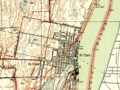
Its Register listing is the St. Clair Inn. Its Register listing is the St. Clair Inn. Below: 2 old photos and papers, maps from 1939 on, and the census since 1860.
The St. Clair post office opened in 1826, the earliest record of the town by name. Wikidata gives 1828. Another post office, Saint Clair (1826), opened inside today’s city and later closed.
First census: 1,530 in 18602020 census: 5,464200 years
How did St. Clair get its name?
St. Clair was named for Lake Saint Clair, named by French explorers in the 17th century.
More on the name
The expedition of French explorer René Robert Cavelier, Sieur de La Salle entered the lake on August 12, 1679, the feast day of Saint Clare of Assisi, and named it Lac Sainte-Claire in her honor.
How historic is St. Clair?
A−
More historic than 83% of U.S. towns, on its age, its old homes and the National Register.
On its age, its old homes and the National Register, St. Clair is more historic than 83% of U.S. towns, #111 of 701 in Michigan. All 3 inputs are above most U.S. towns; its share of homes from before 1940 ranks highest and its National Register listings lowest.
A−
HistoryA character grade: shown, never part of St. Clair’s overall grade.
Few Michigan towns list much on the Register (a typical Michigan town has 0.0 per 10,000 residents, the U.S. 2.4), so St. Clair’s 1.8 sits above most of its state (68% of Michigan towns have fewer) while its 1 listings outnumber those of 51% of U.S. towns.
How sure. Graded on any two of the three inputs instead, the letter would range from B+ to A−. The pre-1940 share is a Census survey estimate (±7.3 points). The founding year is the first post office, not a stated founding date; Wikidata’s 1828 falls in the same era, so the grade doesn’t depend on which one is used.
Founding year: the first post office (other dates in Quick answers). Homes: Census ACS 2020–24. National Register: National Park Service, May 2026 list; each listing counted once (boundary changes and added documentation belong to their listing), and a historic district counts its contributing buildings. How TownRatings grades history →
What stands out about St. Clair’s past
Read from the archive, the National Register and the record. The page puts what stands out first.
Fort, called Fort Sinclair, and was an Indigenous trading post. The oldest standing house is actually part of the fort, but is owned by Johnson Hydraulics. The fort existed in the mid 18th century, when the St, Clair River was used for traveling by explorers, traders, and early settlers. St. Clair was first platted under the name of Palmer by Thomas Palmer in 1828. The city of St. Clair's roots go back to 1764, when a British fort was built on the south side of the Pine River near where it flows into the St. Clair River. Pontiac's Rebellion had taken place the year before and the British wanted a military base on the St. Clair River to protect their shipping route between Detroit and Fort Michilimackinac. Col. Patrick Sinclair was given the task of building it. He also made the new Fort Sinclair a trading post and sawmill center. The fort and the trading post both operated for abou…
Passages that mention St. Clair, cut from the printed page as they were published.
St. Clair County, Michigan, its history and its people1912 · page 139Read the page →
Read the text
James Ogden lived in the township of St. Clair and had a saw mill several miles up Pine river, and later became a partner in the lumbei-ing and saw mill 'Ousiness at St. Clair with Dr. Harmon Chamberlin, until they sold out to Wesley Truesdail in 1852.
Text read by machine from the scan; it may contain errors.
St. Clair County, Michigan, its history and its people1912 · page 251Read the page →
Read the text
It seems to have been customary to lay out a plat and give it a name, as the town of St. Clair, the village of Peru, and trust to the future for inhabitants to make good the name. In common use, the only word which carried with it the necessary implication of a governmental incorporation was city, town or village, and merely meant an actual or proposed settlement of people.
Text read by machine from the scan; it may contain errors.
Scans and text from the Internet Archive. Books published in 1930 or earlier, which are in the public domain.
The St. Clair post office opened in 1826, the earliest record of the town by name (U.S. post office records). Wikidata gives 1828.
How does St. Clair rank for history?
St. Clair is more historic than 83% of U.S. towns, #111 of 701 in Michigan. The History grade combines the town’s founding era, the share of homes built before 1940 and its National Register listings. It’s a character grade, so it isn’t part of the overall grade. How it works.
What is on the National Register in St. Clair?
One place: the St. Clair Inn (listed 1995).
How old are the homes in St. Clair?
25% of St. Clair’s homes were built before 1940 (Census estimate, ±7.3 points), against a typical 12% for a Michigan town; the median home was built in 1959.
Founding dates: Wikidata, Wikipedia, the U.S. post office records of Blevins & Helbock (CC0) and the Census. Homes by year built: Census ACS 2020–24. National Register of Historic Places: National Park Service (list of May 22, 2026). Old photos, postcards and papers: Wikimedia Commons, the Library of Congress and other public archives, credited on each item’s page. Maps: U.S. Geological Survey historical topographic maps (via Esri) and Sanborn fire-insurance maps (Library of Congress). History text and census tables: Wikipedia (CC BY-SA 4.0). Places that used to be: USGS Geographic Names Information System (2021).
From Wikimedia Commons (3), Wikidata (1), the National Register of Historic Places (1), Wikipedia, Wikidata and Wikipedia for famous people, U.S. Geological Survey historical maps, U.S. Census counts (via Wikipedia), the US Post Offices dataset (Blevins & Helbock), the USGS Geographic Names Information System and old county and town histories (Internet Archive). Archive images are copied here with their credits and licenses, shown on each photo’s page. Refreshed monthly.




 Date?
 Date?
 2005


