Guest, Sign inJoin

Post to Detroit

We’ll email a one-tap link to publish your post. No password, and nothing is public until you click it.
Already a member? Sign in
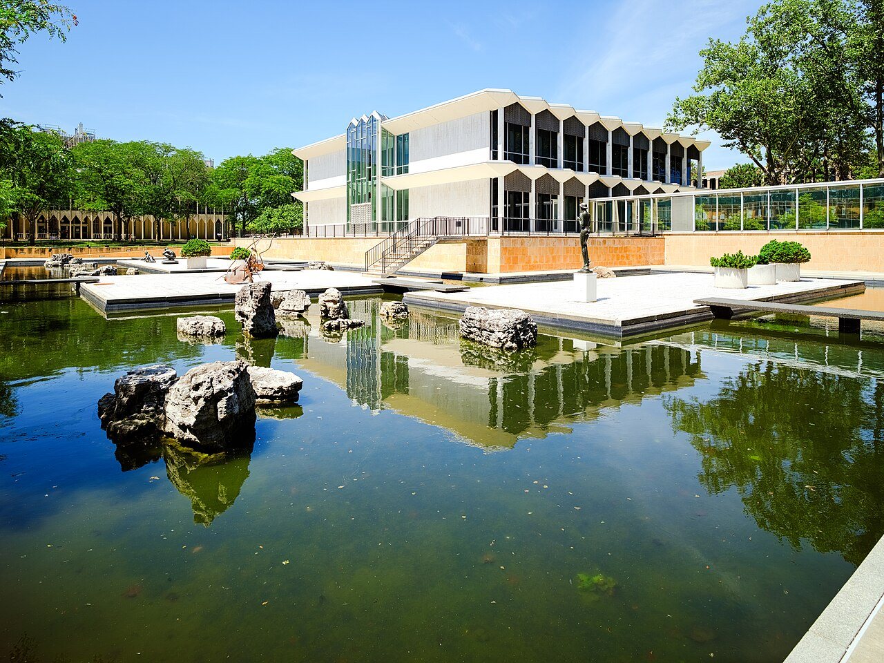
McGregor Memorial Conference CenterMcGregor Memorial Conference Center · Photo: Matt Joseph · CC BY-SA 4.0
B+Outdoors
Outdoors in Detroit

Detroit has 107 miles of mapped trails, 0.8 for every square mile of land

95% of residents live within a half mile of a park. The biggest trail networks: River Rouge Park (13 mi), Belle Isle (11.7 mi), Palmer Park (4.2 mi). 6% of Detroit’s land is conserved, about 5,611 acres.

Ahead of 75% of U.S. towns · #242 of 701 in Michigan. What drives it

Conserved land
6%
5,611 acres · of 138.7 sq mi of land
Trails
107 mi
0.8 per sq mi of land
Park land
5,755 ac
9.0 acres per 1,000 residents
Near a park
95%
of residents within ½ mile
Bike routes
187 mi
88 mi lanes · 65 mi paths
Lakes & rivers
16
2 beaches · 21 boat launches

What kind of outdoors town is Detroit?

Read from the map. The page puts what stands out first.

Outdoors grade

How much outdoors does Detroit have?

On conserved land, trails, park land and how close residents live to a park, Detroit is ahead of 75% of U.S. towns, #242 of 701 in Michigan. The share of residents near a park holds the grade up; park acres per resident pull it down.

B+
OutdoorsA character grade: shown, never part of Detroit’s overall grade.
All U.S. towns we grade (21,298)Ahead of 75%
LessMore
Michigan towns of 2,500+ (701)Ahead of 66%

Among the 400 U.S. cities of 100,000 or more, Detroit ranks #237 on Outdoors.

How sure. Graded on any three of the four inputs instead, the letter would range from B+ to A−. Trails and many small parks come from OpenStreetMap, mapped by volunteers, so coverage varies from town to town; the half mile is a straight line from each census block, so a river or highway in the way isn’t counted against it.

PAD-US, OpenStreetMap (© OpenStreetMap contributors), Census 2025 Gazetteer and 2020 blocks; details in Sources below. How TownRatings grades the outdoors →

The map

Conserved land, trails & bike routes

Tap a number to zoom to a park. Tap a layer to hide it.

12345678
Easements protect land from building but are usually private.© OpenStreetMap contributors · USGS PAD-US
Places to walk

Pick a walk

The longest trail network is River Rouge Park, with 13 miles. Directions go to the nearest trailhead or public parking.

River Rouge Park

Managed by City of Detroit
903 acres13 mi of trail
Rouge Park MTB TrailPrairie PathwayStone Bridge Nature Trail
Dog rules not recorded
Directionsto the trailhead

Belle Isle

Nature preserve
895 acres11.7 mi of trail
Nashua TrailDriker TrailTrout Lily TrailWildwood Trail+1
Dogs on leash
Directionsto the parking lotWebsite ↗

Palmer Park

Park
296 acres4.2 mi of trail
Dog rules not recorded
Directionsto the parking lot

Eliza Howell Park

Managed by City of Detroit
248 acres3.5 mi of trail
Dog rules not recorded
Directionsto the parking lot

Farwell Field

Park
86 acres2.3 mi of trail
Dog rules not recorded
Directionsto the parking lot

Ralph C. Wilson, Jr. Centennial Park

Park
22 acres2.2 mi of trail
Nature Walk
Dog rules not recorded
Directionsto the parking lotWebsite ↗

Chandler Park

Park
201 acres2.1 mi of trail
Dog rules not recorded
Directionsto the parking lot

Riverside Park

Managed by City of Detroit
30 acres2 mi of trail
Detroit Riverwalk
Dog rules not recorded
Directionsto the parking lot
All 296 parks & preserves
River Rouge Park903 acres · 13 mi of trail · City of Detroit
Directions
Belle Isle895 acres · 11.7 mi of trail
Directions
Palmer Park296 acres · 4.2 mi of trail
Directions
Eliza Howell Park248 acres · 3.5 mi of trail · City of Detroit
Directions
Farwell Field86 acres · 2.3 mi of trail
Directions
Ralph C. Wilson, Jr. Centennial Park22 acres · 2.2 mi of trail
Directions
Chandler Park201 acres · 2.1 mi of trail
Directions
Riverside Park30 acres · 2 mi of trail · City of Detroit
Directions
Jayne Playfield48 acres · 1.9 mi of trail
Directions
Clark Park30 acres · 1.8 mi of trail
Directions
Fort Wayne75 acres · 1.7 mi of trail · City of Detroit
Directions
Stoepel Park No. 128 acres · 1.6 mi of trail
Directions
O'Hair Park81 acres · 1.5 mi of trail · Detroit Parks and Recreation
Balduck Memorial Park57 acres · 1.5 mi of trail · Detroit Parks & Recreation Department
Directions
Maheras-Gentry Park56 acres · 1.2 mi of trail · City of Detroit
Directions
Alfred Brush Ford Park31 acres · 1.2 mi of trail · City of Detroit
Directions
Riverfront-Lakewood East Park25 acres · 1.2 mi of trail · City of Detroit
Directions
William G. Milliken State Park21 acres · 1.1 mi of trail
Directions
Adams Butzel Recreation Complex31 acres · 0.9 mi of trail
Directions
Pingree Park19 acres · 0.9 mi of trail
Directions
Comstock Playground27 acres · 0.8 mi of trail
Directions
Hart Plaza10 acres · 0.8 mi of trail
Directions
Hope Playground17 acres · 0.7 mi of trail
Directions
Roosevelt Park11 acres · 0.7 mi of trail
Directions
Peterson Playfield19 acres · 0.6 mi of trail
Directions
Littlefield Playfield12 acres · 0.6 mi of trail
Krainz Park11 acres · 0.6 mi of trail
LaSalle Park5 acres · 0.6 mi of trail
Rogell Park125 acres · 0.5 mi of trail · City of Detroit
Directions
Patton Park65 acres · 0.5 mi of trail
Directions
Romanowski Park26 acres · 0.5 mi of trail
Directions
Stein Playground23 acres · 0.5 mi of trail
Directions
Joe Louis Park13 acres · 0.5 mi of trail
Nardin Park5 acres · 0.5 mi of trail
Directions
Optimist-Stout Playground5 acres · 0.5 mi of trail
Directions
Cass Park5 acres · 0.5 mi of trail · City of Detroit
Directions
Alfonso Wells Memorial Playground5 acres · 0.5 mi of trail
Van Antwerp Park20 acres · 0.4 mi of trail
Directions
Lipke Playground15 acres · 0.4 mi of trail
Milan Playground11 acres · 0.4 mi of trail
Wish Egan Field10 acres · 0.4 mi of trail
Directions
Simanek Playfield8 acres · 0.4 mi of trail
Directions
Forest Park7 acres · 0.4 mi of trail
Directions
Dad Butler Park7 acres · 0.4 mi of trail
Stoepel Park Number 236 acres · 0.3 mi of trail
Gabriel Richard Park17 acres · 0.3 mi of trail
Directions
Heilmann Playfield15 acres · 0.3 mi of trail
Directions
Lasky Park14 acres · 0.3 mi of trail
Directions
Delray Recreation Center10 acres · 0.3 mi of trail
Directions
Joseph Walker Williams Park8 acres · 0.3 mi of trail
Directions
Fields Playground7 acres · 0.3 mi of trail
Directions
Messmer Park6 acres · 0.3 mi of trail
Piwok Park5 acres · 0.3 mi of trail
Directions
Perrien Park5 acres · 0.3 mi of trail
Margaret Simmons Playground5 acres · 0.3 mi of trail
Calimera Park5 acres · 0.3 mi of trail
Grand Circus Park4 acres · 0.3 mi of trail
Directions
Kern Playground4 acres · 0.3 mi of trail
Corrigan Playground4 acres · 0.3 mi of trail
Directions
Cullen Plaza3 acres · 0.3 mi of trail
Directions
Russell Woods Park3 acres · 0.3 mi of trail
Circle Park2 acres · 0.3 mi of trail · DTE
Directions
Oudolf Garden Detroit1 acres · 0.3 mi of trail
Directions
Erma Henderson Park36 acres · 0.2 mi of trail
Directions
O'Shea Playground21 acres · 0.2 mi of trail
Directions
Elmwood Central Park17 acres · 0.2 mi of trail
Campau Park14 acres · 0.2 mi of trail
Directions
St. Hedwig Park13 acres · 0.2 mi of trail
Directions
Gmeiner Park11 acres · 0.2 mi of trail
Directions
Brewer Park8 acres · 0.2 mi of trail
Marruso Park5 acres · 0.2 mi of trail
David P Kelley Jr Playground5 acres · 0.2 mi of trail
Dueweke Park5 acres · 0.2 mi of trail
Directions
Riordan Playground4 acres · 0.2 mi of trail
Belton-Mark Twain Park4 acres · 0.2 mi of trail
Directions
Greenview-Wadsworth Park4 acres · 0.2 mi of trail
Syracuse Playground4 acres · 0.2 mi of trail
Mallett Park4 acres · 0.2 mi of trail
State Fair Park4 acres · 0.2 mi of trail
Directions
Robert C. Valade Park3 acres · 0.2 mi of trail
Directions
Bale Playground3 acres · 0.2 mi of trail
Directions
Arthur Playground3 acres · 0.2 mi of trail
Walter & Mae Reuther Park3 acres · 0.2 mi of trail
Directions
Edmore and Marbud Park3 acres · 0.2 mi of trail
Stockton Park2 acres · 0.2 mi of trail
Howarth Park2 acres · 0.2 mi of trail
Knudsen Park2 acres · 0.2 mi of trail
Scripps Park1 acres · 0.2 mi of trail · City of Detroit
Directions
Dequindre Cut Greenway25 acres · 0.1 mi of trail
Directions
Lafayette Plaisance Park13 acres · 0.1 mi of trail
Directions
Aretha Franklin Park9 acres · 0.1 mi of trail
Directions
Delray Park7 acres · 0.1 mi of trail
Directions
Mariner Park7 acres · 0.1 mi of trail · City of Detroit
Directions
Lafayette Central Park6 acres · 0.1 mi of trail · City of Detroit
Directions
Bradby Park5 acres · 0.1 mi of trail
Ze Mound4 acres · 0.1 mi of trail
Directions
Greene Playground4 acres · 0.1 mi of trail
St. Martins Park4 acres · 0.1 mi of trail
Directions
Lloyd H. Ryan Playground4 acres · 0.1 mi of trail
Directions
Hardstein Playground4 acres · 0.1 mi of trail
Clinton Park (DPS)3 acres · 0.1 mi of trail
Weaver-Penrod Park3 acres · 0.1 mi of trail
Tuttle Playground3 acres · 0.1 mi of trail
Varrier Playground3 acres · 0.1 mi of trail
Votrobeck Playground3 acres · 0.1 mi of trail
Directions
Ralph Bunche Cooperative Park3 acres · 0.1 mi of trail
Directions
Hackett Playground3 acres · 0.1 mi of trail
Viola Liuzzo Playground3 acres · 0.1 mi of trail
Directions
Yates Park3 acres · 0.1 mi of trail
Directions
Community Park2 acres · 0.1 mi of trail
Directions
Marx Playground2 acres · 0.1 mi of trail
Directions
Diack Playground2 acres · 0.1 mi of trail
Gorham Playground2 acres · 0.1 mi of trail
Doan Playground2 acres · 0.1 mi of trail
Directions
Cook Playground2 acres · 0.1 mi of trail
Dean Savage Memorial Park2 acres · 0.1 mi of trail
Directions
Hansen Playground2 acres · 0.1 mi of trail · City of Detroit
Directions
Sawyer Playground2 acres · 0.1 mi of trail
Harold Cross Park2 acres · 0.1 mi of trail
Military-Regular Park2 acres · 0.1 mi of trail
Mollicone Park1 acres · 0.1 mi of trail
Directions
Johnson Park1 acres · 0.1 mi of trail
Rosemont-Acacia Park1 acres · 0.1 mi of trail
Directions
Laker Park1 acres · 0.1 mi of trail
McDuffy Park1 acres · 0.1 mi of trail
O'Brien Playground1 acres · 0.1 mi of trail
Greening of Detroit Park1 acres · 0.1 mi of trail
Directions
Walter Sak Playground1 acres · 0.1 mi of trail
Douglas Ramsay Memorial Playground1 acres · 0.1 mi of trail
Directions
30th-Herbert Park1 acres · 0.1 mi of trail
Riverfront Garden Rooms1 acres · 0.1 mi of trail
Directions
Gordon Park1 acres · 0.1 mi of trail
Weiss Playground1 acres · 0.1 mi of trail
John R. Watson Park1 acres · 0.1 mi of trail
Directions
Oxygen Alley1 acres · 0.1 mi of trail
Directions
Wigle New Park1 acres · 0.1 mi of trail
Directions
Marx-Remington Park1 acres · 0.1 mi of trail
Lafayette-NYCRR Park1 acres · 0.1 mi of trail
Stanton Park1 acres · 0.1 mi of trail
Directions
Harmonie Park1 acres · 0.1 mi of trail
Directions
Bryant Vermont Park1 acres · 0.1 mi of trail
Directions
Rouge Valley Parkway99 acres
Directions
Outer Drive Fullerton Park50 acres
Dorais Park30 acres
Directions
Reid Memorial Park28 acres · City of Detroit
Directions
Kemeney Park21 acres
Directions
Hammerberg Park21 acres
Directions
Connor Playfield19 acres
Dingeman Park15 acres · Detroit Public Schools
Directions
Lodge Playground13 acres
Directions
Engel Memorial Park11 acres · City of Detroit
Sasser Playfield11 acres
Salsinger Playground11 acres
Directions
Tolan Park9 acres
Owen Park8 acres
Directions
Butzel Playground7 acres
Directions
Manz Playfield7 acres
Directions
Leroy Dues Playfield7 acres
Directions
Voigt Park7 acres
Forman Park7 acres
Edward G. Heckel Park7 acres
Directions
Hunt Playground6 acres
Directions
Arthur L. Fletcher Playfield6 acres
McCabe Park6 acres
Hines Parkway5 acres
Directions
North Rosedale Park Community House & Grounds5 acres
Directions
Nagel Park5 acres · City of Detroit
Directions
Skinner Playfield5 acres
Directions
Bessy Playground5 acres
Directions
Tireman-Littlefield4 acres
Bridgeview Park4 acres
Markulis Playground4 acres
Warren-Meldrum Park4 acres
Directions
Mt. Elliot Park3 acres
Directions
Bieniek Park3 acres
Margareta Park3 acres
James Vernor Playground3 acres
Directions
Brush Mall3 acres · Detroit Medical Center
Directions
Schuster Playground3 acres
Directions
Sylvester-Seyburn Park3 acres
Directions
Martz Park3 acres
Stout Park3 acres
Outer Drive-Burgess Park3 acres
Directions
Intervale-Roselawn Park3 acres
John C. Luger Playground3 acres · Hartford Memorial Baptist Church
Directions
Algonquin-Goethe3 acres
Reuther Mall3 acres
Directions
Biraga Playground3 acres
Brush Park3 acres · City of Detroit
Directions
Castador Park3 acres
Directions
Fargo-Oakfield Park3 acres
Molena-Castle Playground3 acres
Zussman Playground3 acres
Directions
Luce-St. Louis Playground3 acres
Directions
Fitzpatrick-Warwick Playground3 acres
Directions
Cadillac Square Park3 acres
Directions
Bringard-Boulder Park3 acres
Collins Park3 acres
Directions
Troester-Hayes3 acres
Phelps Playground2 acres
Optimist-Parkgrove Playground2 acres
Latham Playground2 acres
Fitzpatrick Park2 acres
Fargo-Fenton Park2 acres · City of Detroit
Robinwood Park2 acres
Evans Park2 acres
Conant-Minnesota Park2 acres
Directions
Pallister Park2 acres
Directions
Shirley-Plymouth Park2 acres
Higgins Park2 acres · Detroit Public Schools
Peck Park2 acres
Bradley Playground2 acres
Directions
Rudolph Szafraniec Playground2 acres
Directions
Beland Manning Park2 acres
Dolores Benett Park2 acres
Directions
Virginia Park Gateway2 acres · Parks of New Center
Directions
Conner Parkway2 acres
Watson Playground2 acres
Directions
Calcara Park2 acres
Midland-Bentler Playground2 acres
Woodward and Warren Park1 acres
Directions
CCS Sculpture Garden1 acres
Directions
Mansfield-Diversey Playground1 acres
Saint Anthony Playground1 acres
Directions
Boyer Playfield1 acres
Directions
Seven Mile-Appleton Playground1 acres
Dabrowski Park1 acres
Directions
Campus Martius Park1 acres · Downtown Detroit Partnership
Directions
Brookins Park1 acres
Callahan Playground1 acres
John Thomas Yaksich Park1 acres
Ben Hill Playground1 acres
Circle Forest1 acres
Directions
McShane Park1 acres
Directions
4-H Park1 acres · Brighter Detroit
Directions
Beacon Park1 acres
Directions
Litsitz Memorial Playground1 acres
Directions
Ewald Playground1 acres
Keast Commons1 acres
Reid Park1 acres
Ames Park1 acres
Burns-Lambert Park1 acres
Malish Playground1 acres · City of Detroit
Directions
Traverse-McClellan1 acres
Fountain Court1 acres
Directions
Scarcyny Park & Garden1 acres
Frederick Linsell Green1 acres
Directions
Mackay-Modern Park1 acres
Wilson Park1 acres
Downey Playlot1 acres
Directions
Keith Slappy Park1 acres
Armour-Knodell Park1 acres
Lincoln Street Art Park1 acres
Directions
Maiullo Park1 acres · City of Detroit
Directions
Grayfield-Glenhurst Park1 acres
Directions
Muliett Park1 acres
Directions
CCS Business Green1 acres
Directions
Constance-St. Marys Park1 acres
Kiwanis Club No. 11 acres
Directions
Hyde Park1 acres
Directions
Keidan Park1 acres
Directions
WSU East Campus Green1 acres
Directions
Knox Court Park1 acres · First Independence National Bank
Directions
Coventry Park1 acres
Directions
Centenntial Garden1 acres
Dequindre-Grixdale Park1 acres
Capitol Park1 acres
Directions
Karaniewski Park1 acres
Directions
Beniteau Community Park1 acres · Rebuilding Communities, Inc.
Directions
Harvey-Junction Park1 acres
Facsko Park1 acres
Buffalo Soldiers Memorial Park1 acres
Woodward-7 Mile Park1 acres
Directions
Sirotkin Park1 acres
Twork Park1 acres
Dinning Park1 acres
Fiori Park1 acres
New Center Park1 acres
Directions
Russell-Maderiea1 acres · City of Detroit
Murphy Playlot1 acres
Directions
Lafayette Greens1 acres
Directions
City Sculpture Park1 acres · Robert Sestok
Crockett Park1 acres
Directions
4th Street-Charlotte Playground1 acres
Directions
Fort Street Bridge Park1 acres
Directions
Hantz Playground1 acres
Directions
Beard Park1 acres
Directions
Belden-Santa Maria Park1 acres
Directions
Conant Gardens Association Park1 acres · Conant Gardens Property Owners Association
Directions
Commonwealth-Marquette Park1 acres
Directions
Puritan-Coyle Park1 acres
Mt. Elliott-Zender Park1 acres
Directions
Couzens-Outer Drive Park1 acres
Sherwood Park1 acres
Directions
25th-Toledo Park1 acres
Canfield-Sheriden Park1 acres
Directions
Who protects it

5,611 conserved acres

6% of Detroit’s land. Who manages Detroit’s conserved land, from the USGS Protected Areas Database. Approximate, because parcels can overlap.

Town or city5,004 ac
Private owners356 ac
State natural resources215 ac
Other state land23 ac
County7 ac
Land trusts & nonprofits4 ac
Regional agency3 ac
Local Park · 4,083 acLocal Recreation Area · 959 acPrivate Park · 350 acState Recreation Area · 187 acState Park · 28 ac
The biggest protected parcels
Parcel (PAD-US)Managed byAcresPublic access
Rouge Park
Local Park
Town or city1,105Open
Belle Isle
Local Park
Town or city920Open
Palmer
Local Park
Town or city294Open
Detroit Golf Club
Private Park
Private owners283Restricted
Eliza Howell
Local Park
Town or city250Open
Chandler
Local Park
Town or city197Open
Michigan State Fairgrounds
State Recreation Area
State natural resources187Open
Rogell Golf Course
Local Recreation Area
Town or city128Open
Farwell
Local Park
Town or city89Open
O'Hair
Local Park
Town or city78Open

5 smaller protected places aren’t shown.

Things to do

494 places to go in Detroit

Beaches, playgrounds, peaks, falls and more. Pick a kind.

Boat launches in Detroit
Kayak/Canoe Launch
Directions
Kayak/Canoe Launch
Directions
Kayak/Canoe Launch (Marshall's Bar)
Directions
Kayak/Paddleboard Boat LaunchIn Belle Isle
Directions
Kayak/Paddleboard Boat LaunchIn Belle Isle
Directions
Kayak/Paddleboard Boat Launch
Directions
St. Jean Boat LaunchIn Reid Memorial Park
Directions

Plus 14 boat launches without a name on the map.

Trails & water

13 named trails and 16 lakes & rivers

Named trails
Open to bikes · 32.6 miUnpaved · 8.2 mi
Rouge Park MTB Trail2.2 mi
Joe Louis Greenway1.7 mi
Prairie Pathway1.5 mi
Nashua Trail0.8 mi
Driker Trail0.8 mi
Trout Lily Trail0.6 mi
Stone Bridge Nature Trail0.6 mi
Detroit Riverwalk0.6 mi
Wildwood Trail0.5 mi
Sedge Meadow Trail0.3 mi
3 more trails
Shadownook Trail
0.2 mi
Nature Walk
0.1 mi
Oxbow Fishing Platform
0.1 mi
Lakes & rivers tap for directions
Biking & sports

187 miles of bike routes

Bike lanes are often missing from the map in smaller towns, so that number is likely low.

88 mi
painted or protected bike lanes
65 mi
off-road bike paths
34 mi
shoulders & shared lanes
Detroit Slow Streets NetworkBike route
0.6 mi
Courts & fields
199Tennis
169Basketball
123Baseball
59Soccer
27Football
18Pickleball
9Beach volleyball
7Skate park

Includes school and college facilities, which aren’t always open to the public.

History along the way

282 places on the National Register, 12 of them National Historic Landmarks

The country’s official list of places worth saving (National Park Service). The map also marks 73 historic points from OpenStreetMap: plaques, memorials and old buildings.

History →
★
Pewabic PotteryNational Historic Landmark · Building · listed 1971
About it
★
Parke-Davis Research LaboratoryNational Historic Landmark · Building · listed 1976
About it
★
General Motors BuildingNational Historic Landmark · Building · listed 1978
About it
★
Fisher and New Center BuildingsNational Historic Landmark · Building · listed 1980
About it
★
Fox Theater BuildingNational Historic Landmark · Building · listed 1985
About it
★
Fisher BuildingNational Historic Landmark · Building · listed 1989
About it
★
Guardian BuildingNational Historic Landmark · Building · listed 1989
About it
★
Ford Piquette Avenue PlantNational Historic Landmark · Building · listed 2002
About it
★
McGregor Memorial Conference CenterNational Historic Landmark · Building · listed 2010
About it
★
Detroit Industry Murals, Detroit Institute of ArtsNational Historic Landmark · Object · listed 2014
About it
★
Lafayette ParkNational Historic Landmark · Place · listed 2015
About it
Christ Church, DetroitBuilding · listed 1971
About it

270 more on the History page.

When to get out

The best walking months in Detroit: June to September

NOAA’s 1991–2020 normals for the town and the daylight at its latitude. Outlined months have long days, highs of 59 to 86 °F and little rain for the place.

JanFebMarAprMayJunJulAugSepOctNovDec
Daylight (h)9.410.511.813.314.615.315.013.912.411.09.79.1
High (°F)323545587080848175624837
Rain (in)2.32.02.43.23.73.33.43.43.22.72.62.2

February is the driest month (2.0 in) and July the warmest (highs of 84 °F). 3.7 inches fall in May, the wettest month. The climate in Detroit →

Next door

Detroit and its neighbors

Detroit has the most mapped trails of the 8 towns around it. Tap a town to see its outdoors.

TownConserved
of land
Trail mi
per sq mi
Park acres
per 1,000
Near a park
½ mile
Outdoors
Detroit6%0.8995%B+
Dearborn11%2.01598%A
River Rouge2%0.2599%+B−
Grosse Pointe Park2%under 0.1384%C
Dearborn Heights12%0.61395%A−
Melvindale2%0.3699%+B
Harper Woods2%0.4281%C+
Redford Township5%0.3497%B

The four inputs of the Outdoors grade, from the engine; shares are of land, not water.

Questions about parks and trails in Detroit

Where can I hike in Detroit?

The longest trail networks: River Rouge Park, 13 miles; Belle Isle, 11.7 miles; Palmer Park, 4.2 miles; Eliza Howell Park, 3.5 miles. Each one is on the map above, with directions to the nearest trailhead or parking.

How much of Detroit is conserved land?

6% of its land, against a typical 5% for a Michigan town and 4% nationally (PAD-US). Conserved doesn’t always mean open to visitors: easements are usually private land.

Are dogs allowed on Detroit’s trails?

OpenStreetMap records dogs as welcome at Belle Isle (on leash). For the rest, check the signs at the trailhead.

Where can I bike in Detroit?

187 miles of bike routes are on the map: 88 of painted or protected lanes, 65 of off-road paths and 34 of shoulders and shared lanes. Named routes: Detroit Slow Streets Network.

Is there public land near Detroit?

22,334 acres of parks and open public land lie inside Detroit or within 10 miles of it (PAD-US), 5,755 of them inside the city line.

How much outdoors does Detroit have?

Ahead of 75% of U.S. towns on the Outdoors grade, #242 of 701 in Michigan. The grade combines the share of land that is conserved, miles of mapped trail per square mile of land, park acres per 1,000 residents and the share of residents within a half mile of a park. It’s a character grade, so it isn’t part of the overall grade. How it works.

Trail talk

Conditions, parking and favorite walks from Detroit neighbors.

Town Square →
Share a tip
Sources

Where this page comes from

Conserved and public land: USGS Protected Areas Database of the United States (PAD-US), service updated July 2026. Parks, trails, playgrounds, beaches and other places: OpenStreetMap (© OpenStreetMap contributors, ODbL), map data as of 2026-10-28. Land and water area: Census 2025 Gazetteer. Residents near a park: 2020 Census blocks. National Register: National Park Service. How TownRatings grades the outdoors →