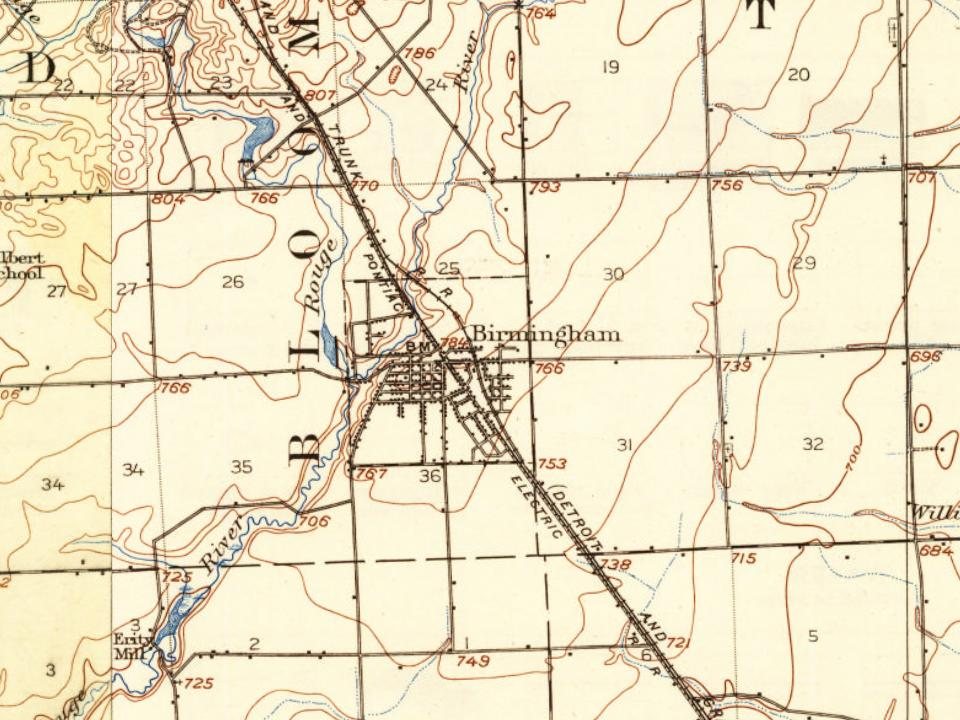
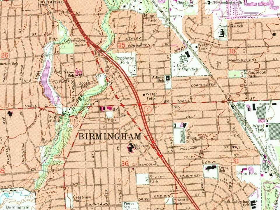
Birmingham dates to 1819, and 16% of its homes were built before 1940
More historic than 79% of U.S. towns · #135 of 701 in Michigan. What drives it
Its Register listings are the John W. Hunter House, the Grand Trunk Western Railroad Birmingham Depot and the Derby Street-Grand Trunk Western Railroad Bridge. Its Register listings are the John W. Hunter House, the Grand Trunk Western Railroad Birmingham Depot and the Derby Street-Grand Trunk Western Railroad Bridge. Below: 15 old photos and papers, maps from 1893 on, and the census since 1880.
Founding year: Wikidata. First post office: 1821.The full story ↓
History grade
What drives Birmingham’s History grade
On its age, its old homes and the National Register, Birmingham is more historic than 79% of U.S. towns, #135 of 701 in Michigan. All 3 inputs are above most U.S. towns; its age ranks highest and its share of homes from before 1940 lowest.
A−
HistoryA character grade: shown, never part of Birmingham’s overall grade.
Few Michigan towns list much on the Register (a typical Michigan town has 0.0 per 10,000 residents, the U.S. 2.4), so Birmingham’s 1.4 sits above most of its state (67% of Michigan towns have fewer) while its 3 listings outnumber those of 65% of U.S. towns.
How sure. Graded on any two of the three inputs instead, the letter would range from B+ to A−. The pre-1940 share (±1.9 points) is firm at this size. Two sources give 1819.
Founding year: Wikidata (other dates in Quick answers). Homes: Census ACS 2020–24. National Register: National Park Service, May 2026 list; each listing counted once (boundary changes and added documentation belong to their listing), and a historic district counts its contributing buildings. How TownRatings grades history →
What stands out about Birmingham’s past
Read from the archive, the National Register and the record. The page puts what stands out first.
Fire insurance maps drew every building, what it was made of and what it was used for, so insurers could price the risk of fire. Pick a year, then a sheet.
1893Sheet 1 of 1
Edition
Sheets
BrickWoodStone
Sanborn Map Company, via the Library of Congress. Editions published in 1930 or earlier, which are in the public domain.
By decade
Birmingham, decade by decade
4 decades in the archive, from the 1910s to the 1980s. Scroll each row; tap a photo for its story.
Nothing in the archives for these yearsWeddings on Main Street, storms, parades, school pictures, the old store. If it’s in your family album, it belongs here.
The area comprising what is now the city of Birmingham was part of land ceded by Native American tribes to the United States government through the 1807 Treaty of Detroit. However, settlement was delayed, first by the War of 1812. Afterward the Surveyor-General of the United States, Edward Tiffin, made an unfavorable report regarding the placement of Military Bounty Lands for veterans of the War of 1812. Tiffin's report claimed that, because of marsh, in this area "There would not be an acre out of a hundred, if there would be one out of a thousand that would, in any case, admit cultivation." In 1818, Territorial Governor Lewis Cass led a group of men along the Indian Trail. The governor's party discovered that the swamp was not as extensive as Tiffin had supposed. Not long after Cass issued a more encouraging report about the land, interest quickened as to its suitability for settlemen…
Passages that mention Birmingham, cut from the printed page as they were published.
History of Oakland County, Michigan1912 · page 381Read the page →
Read the text
\'iLL.\GE OF Birmingham The original plat of Birmingham was surveyed and dated August 25, 1836, being located on the northwest quarter of section 36, Roswell T. Merrill, proprietor. l*"our additions were made to it prior to its incorporation as a village, by the board of supervisors in Jaiuiary, 1864.
Text read by machine from the scan; it may contain errors.
History of Oakland County, Michigan1912 · page 489Read the page →
Read the text
In 1894 a part of thp Troy congregation organized another body in the town of Birmingham, both congregations continuing under the one pastorate. A beautiful house of worship has been erected and a flourishing congregation exists today in Birmingham. The pastors of the Birmingham church thus far have been Rev. A. H. Orr, Rev. M. B. Maxwell, Rev. J. W. J-ood; Rev. R. J. Pinkerton and Rev. Reid, now in charge.
Text read by machine from the scan; it may contain errors.
Scans and text from the Internet Archive. Books published in 1930 or earlier, which are in the public domain.
Timeline
Birmingham, 1819 to 1986
Woven from the archive, old maps, post office records, the National Register and the people born here.
In 1819, according to Wikidata. Birmingham’s post office opened in 1821, and the census of 1880 counted 733 people here.
How does Birmingham rank for history?
Birmingham is more historic than 79% of U.S. towns, #135 of 701 in Michigan. The History grade combines the town’s founding era, the share of homes built before 1940 and its National Register listings. It’s a character grade, so it isn’t part of the overall grade. How it works.
What is on the National Register in Birmingham?
Three places: the John W. Hunter House (listed 1972), the Grand Trunk Western Railroad Birmingham Depot (1985) and the Derby Street-Grand Trunk Western Railroad Bridge (2000).
How old are the homes in Birmingham?
16% of Birmingham’s homes were built before 1940 (Census estimate, ±1.9 points), against a typical 12% for a Michigan town; the median home was built in 1960.
Founding dates: Wikidata, Wikipedia, the U.S. post office records of Blevins & Helbock (CC0) and the Census. Homes by year built: Census ACS 2020–24. National Register of Historic Places: National Park Service (list of May 22, 2026). Old photos, postcards and papers: Wikimedia Commons, the Library of Congress and other public archives, credited on each item’s page. Maps: U.S. Geological Survey historical topographic maps (via Esri) and Sanborn fire-insurance maps (Library of Congress). History text and census tables: Wikipedia (CC BY-SA 4.0). Places that used to be: USGS Geographic Names Information System (2021).
From Wikimedia Commons (6), the Library of Congress (12), the National Register of Historic Places (3), Wikipedia, Wikidata and Wikipedia for famous people, U.S. Geological Survey historical maps, U.S. Census counts (via Wikipedia), the US Post Offices dataset (Blevins & Helbock), the USGS Geographic Names Information System, Sanborn fire insurance maps (Library of Congress) and old county and town histories (Internet Archive). Archive images are copied here with their credits and licenses, shown on each photo’s page. Refreshed monthly.


 1910
 1942
 1942
 1942
 1942
 1942
 1942
 1942
 1942
 1942
 1942
 1942
 1976
 1976
 1986
 2010
 2008
 2002