Baraga Township dates to 1843, and 19% of its homes were built before 1940
More historic than 88% of U.S. towns · #81 of 701 in Michigan. What drives it
3 places in town are on the National Register, among them two historic districts with 11 buildings between them. Below: 5 old photos and papers, maps from 1954 on, and the census since 1900.
Founding year: Wikidata. First post office: 1875.The full story ↓
History grade
What drives Baraga Township’s History grade
On its age, its old homes and the National Register, Baraga Township is more historic than 88% of U.S. towns, #81 of 701 in Michigan. All 3 inputs are above most U.S. towns; its National Register listings ranks highest and its share of homes from before 1940 lowest.
A
HistoryA character grade: shown, never part of Baraga Township’s overall grade.
Few Michigan towns list much on the Register (a typical Michigan town has 0.0 per 10,000 residents, the U.S. 2.4), so Baraga Township’s 30.9 sits above most of its state (88% of Michigan towns have fewer) while its 11 historic buildings outnumber those of 76% of U.S. towns.
NoteThe founding year comes from Wikidata alone; no second source gives 1843.
How sure. Graded on any two of the three inputs instead, the letter would range from A− to A. The pre-1940 share is a Census survey estimate (±4.5 points).
Founding year: Wikidata (other dates in Quick answers). Homes: Census ACS 2020–24. National Register: National Park Service, May 2026 list; each listing counted once (boundary changes and added documentation belong to their listing), and a historic district counts its contributing buildings. How TownRatings grades history →
What stands out about Baraga Township’s past
Read from the archive, the National Register and the record. The page puts what stands out first.
Lost post offices, old corners, places now gone and burying grounds
Six other post offices opened and closed inside today’s town.
Baraga
1875–today
Fewsville
1875–1877
Newtonville
1884–1897
Giddings
1888–1889
Assinins
1894–1914
La Fernier
1898–1901
Arnheim
1900–1951
Pelkie
1903–today
18701950today
Hamlets and corners on the map
ArnheimAssininsBaragaBear TownKeweenaw BayPelkie
Gone or out of use
Arnheim Post Officepost officeArnheim StationlocaleAssinins Post Officepost officeAssinins StationlocaleBaraga AirportairportGiddings Post Officepost officeKeweenaw Bay Post Officepost officeKeweenaw StationlocaleNewtonville Post Officepost officeNewtonville StationlocalePelkie Grade SchoolschoolPelkie Stationlocale
4cemeteries and burying grounds inside Baraga Township
AssininsBaraga VillageKeweenaw BayPelkie
US Post Offices dataset (Blevins & Helbock, CC0). Places and cemeteries from the USGS Geographic Names Information System (2021).
Timeline
Baraga Township, 1843 to 1954
Woven from the archive, old maps, post office records, the National Register and the people born here.
Baraga began with the establishment of the Holy Name Mission at this site by Rev. Frederic Baraga in 1843.
The post office opened with the name Bristol on June 29, 1869, and changed to Baraga on May 11, 1870.
In 1993, the Baraga Correctional Facility was opened in the town.
On May 30, 2022, a consortium including Finnish technology giant Wärtsilä, the Electric Power Research Institute (EPRI), and Burns & McDonnell unveiled a contract with Milwaukee-based WEC Energy's subsidiary Upper Michigan Energy Resources for a fuel testing pilot.
Nothing in the archives for these yearsWeddings on Main Street, storms, parades, school pictures, the old store. If it’s in your family album, it belongs here.
Every edition of the U.S. Geological Survey’s map of Baraga Township. Tap a year, or press play to watch the town change.
1954Sidnaw sheet · 1:62,500
U.S. Geological Survey historical topographic maps (public domain), via Esri’s collection of the scans. The red ring marks the center of Baraga Township.
Then & now
Stand where they stood
No then-and-now pairs yet. Take a photo from the same spot as an old one and they appear here side by side.
Retake this viewChurch. Baraga, Michigan, 1941
Find the spot, match the angle, and add your photo. It becomes the first then-and-now pair on Baraga Township’s page.
In 1843, according to Wikidata. Baraga Township’s post office opened in 1875, and the census of 1900 counted 1,185 people here.
How does Baraga Township rank for history?
Baraga Township is more historic than 88% of U.S. towns, #81 of 701 in Michigan. The History grade combines the town’s founding era, the share of homes built before 1940 and its National Register listings. It’s a character grade, so it isn’t part of the overall grade. How it works.
What is on the National Register in Baraga Township?
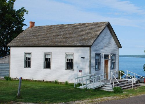
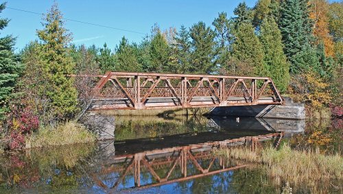
Three places: the Assinins (listed 1972), the Herman and Anna Hanka Farm (1984) and the US-41 (old)-Backwater Creek Bridge (1999).
How old are the homes in Baraga Township?
19% of Baraga Township’s homes were built before 1940 (Census estimate, ±4.5 points), against a typical 12% for a Michigan town; the median home was built in 1972.
Founding dates: Wikidata, Wikipedia, the U.S. post office records of Blevins & Helbock (CC0) and the Census. Homes by year built: Census ACS 2020–24. National Register of Historic Places: National Park Service (list of May 22, 2026). Old photos, postcards and papers: Wikimedia Commons, the Library of Congress and other public archives, credited on each item’s page. Maps: U.S. Geological Survey historical topographic maps (via Esri) and Sanborn fire-insurance maps (Library of Congress). History text and census tables: Wikipedia (CC BY-SA 4.0). Places that used to be: USGS Geographic Names Information System (2021).
From Wikimedia Commons (10), the Library of Congress (5), the National Register of Historic Places (3), Wikipedia, U.S. Geological Survey historical maps, U.S. Census counts (via Wikipedia), the US Post Offices dataset (Blevins & Helbock) and the USGS Geographic Names Information System. Archive images are copied here with their credits and licenses, shown on each photo’s page. Refreshed monthly.


 1941
 1941
 1941
 Date?
 2020
 2018
 2010
 2010
 2010
 2010
 2010
 2010
 2010
 2005