Winthrop dates to 1765, and 24% of its homes were built before 1940
More historic than 91% of U.S. towns · #39 of 143 in Maine. What drives it
4 places in town are on the National Register, among them a historic district with 5 buildings. Below: 23 old photos and papers, maps from 1885 on, and the census since 1790.
On its age, its old homes and the National Register, Winthrop is more historic than 91% of U.S. towns, #39 of 143 in Maine. All 3 inputs are above most U.S. towns; its age ranks highest and its National Register listings lowest.
A
HistoryA character grade: shown, never part of Winthrop’s overall grade.
Maine towns list more on the Register than most of the country (a typical Maine town has 15.9 per 10,000 residents, the U.S. 2.4), so Winthrop’s 12.9 sits near the middle of its state (49% of Maine towns have fewer) while its 8 historic buildings outnumber those of 74% of U.S. towns.
NoteThe founding year comes from Wikidata alone; no second source gives 1765.
How sure. Graded on any two of the three inputs instead, the letter would range from A− to A+. The pre-1940 share is a Census survey estimate (±6.9 points).
Founding year: Wikidata (other dates in Quick answers). Homes: Census ACS 2020–24. National Register: National Park Service, May 2026 list; each listing counted once (boundary changes and added documentation belong to their listing), and a historic district counts its contributing buildings. How TownRatings grades history →
What stands out about Winthrop’s past
Read from the archive, the National Register and the record. The page puts what stands out first.
Nothing in the archives for these yearsWeddings on Main Street, storms, parades, school pictures, the old store. If it’s in your family album, it belongs here.
Nothing in the archives for these yearsWeddings on Main Street, storms, parades, school pictures, the old store. If it’s in your family album, it belongs here.
Every edition of the U.S. Geological Survey’s map of Winthrop. Tap a year, or press play to watch the town change.
1892Augusta sheet · 1:62,500
U.S. Geological Survey historical topographic maps (public domain), via Esri’s collection of the scans. The red ring marks the center of Winthrop.
Places that used to be
Lost post offices, old corners and burying grounds
Winthrop’s post office has been open since 1794. Two other post offices opened and closed inside today’s town.
Winthrop
1794–today
East Winthrop
1829–today
Winthrop Center
1886–1928
Maranacook
1891–1955
17901910today
Hamlets and corners on the map
East WinthropIsland ParkMaranacookSturtevant HillTallwoodWinthrop Center
5cemeteries and burying grounds inside Winthrop
East WinthropGlensideLakeviewMapleMetcalf
US Post Offices dataset (Blevins & Helbock, CC0). Places and cemeteries from the USGS Geographic Names Information System (2021).
The story so far
Winthrop, in brief
Wikipedia doesn’t have a history of Winthrop yet. The photos, dates and memories neighbors add here are how it gets written.
Winthrop is a town in Kennebec County, Maine, United States. Winthrop is included in the Lewiston-Auburn, Maine metropolitan New England City and Town Area. The population was 6,121 at the 2020 census. Winthrop's population, however, approximately doubles during the summer months as part-year residents return to seasonal camps located on the shores of Winthrop's Lakes and Ponds. A recreational area located among lakes, the town includes the villages of Winthrop and East Winthrop, and is the center of the Winthrop Lakes Region. Winthrop is also included in the Augusta, Maine Micropolitan New England City and Town Area. The town is defined by several significant bodies of water, including Mar…
Winthrop was established in 1765. Its population held steady between the last two censuses: 6,092 in 2010, 6,121 in 2020.
Intro from Wikipedia. Population: U.S. Census Bureau.
From the old history books
What they wrote about Winthrop, 1892–1898
Passages that mention Winthrop, cut from the printed page as they were published.
Illustrated history of Kennebec County, Maine1892 · page 168Read the page →
Read the text
The Albert H. Frost Post. No. 21, named after a private who was killed at Gettysburg, was organized at Winthrop June 5, 1879, and now has seventy-seven members living mostly in the towns of Winthrop and Wayne. Meetings are held twice each month in the village of Winthrop. L. T. Carlton, the first commander, has been succeeded by Alexander G. H. Wood, Franklin Wood, Sewall Pettingill, E. O.
Text read by machine from the scan; it may contain errors.
Illustrated history of Kennebec County, Maine1892 · page 834Read the page →
Read the text
to sustain regular meetings. During the years 1806, '7 and '8 there was preaching once in two weeks, in the school house in th esoutheast part of the town. In 1811 the Massachusetts legislature incorporated the Methodist Society in the town of Winthrop, which demanded, in 1816, the interest on the ministerial fund toward the support of their Methodist preacher. The town refused this demand, and in 1819 the parish sued the town and obtained final judgment. This, however, did not settle the matter, the general .sentiment of the town being
Text read by machine from the scan; it may contain errors.
History of the town of Wayne, Kennebec County, Maine, from its settlement to 18981898 · page 71Read the page →
Read the text
"no road, only a line of spotted trees between this settlement and the Kennebec River." He went "to the westward" in the spring of 1769, and came back in November, 1774, The town was then incorporated by the name of Winthrop and had a large population. Immediately upon the news of the battle of Lexington, Nathaniel Fairbanks and eighteen other young men went to provincial headquarters at Cambridge, Mass., ready to take up arms in defence of their country. Mr. Fairbanks was in Capt. Samuel McCobb's com-
Text read by machine from the scan; it may contain errors.
History of the town of Wayne, Kennebec County, Maine, from its settlement to 18981898 · page 242Read the page →
Read the text
formerly stood in the sands of Beech hill, near the dwelling of the late H. J. Ridley, in Wayne. From this school house many teachers, and several persons of more or less eminence, have been sent out. From there he went to Towle Academy, in the town of Winthrop, where he was first in his classes, under the tuition of Prof C. K. Hutchins. He next went to Lewiston to the Maine State Seminary where he completed his preparatory course. During this time the winter months found him imparting to others his attainments in the capacity of teacher,
Text read by machine from the scan; it may contain errors.
Scans and text from the Internet Archive. Books published in 1930 or earlier, which are in the public domain.
Timeline
Winthrop, 1765 to 1984
Woven from the archive, old maps, post office records, the National Register and the people born here.
Fire insurance maps drew every building, what it was made of and what it was used for, so insurers could price the risk of fire. Pick a year, then a sheet.
1885Sheet 1 of 1
Edition
Sheets
BrickWoodStone
Sanborn Map Company, via the Library of Congress. Editions published in 1930 or earlier, which are in the public domain.
In 1765, according to Wikidata. Winthrop’s post office opened in 1794, and the first U.S. census counted 1,226 people here in 1790.
How does Winthrop rank for history?
Winthrop is more historic than 91% of U.S. towns, #39 of 143 in Maine. The History grade combines the town’s founding era, the share of homes built before 1940 and its National Register listings. It’s a character grade, so it isn’t part of the overall grade. How it works.
What is on the National Register in Winthrop?
4 listings: 2 buildings, 1 historic district, the Winthrop Mills Company, with 5 contributing buildings, and 1 structure. 8 historic buildings in all.
How old are the homes in Winthrop?
24% of Winthrop’s homes were built before 1940 (Census estimate, ±6.9 points), against a typical 19% for a Maine town; the median home was built in 1977.
Founding dates: Wikidata, Wikipedia, the U.S. post office records of Blevins & Helbock (CC0) and the Census. Homes by year built: Census ACS 2020–24. National Register of Historic Places: National Park Service (list of May 22, 2026). Old photos, postcards and papers: Wikimedia Commons, the Library of Congress and other public archives, credited on each item’s page. Maps: U.S. Geological Survey historical topographic maps (via Esri) and Sanborn fire-insurance maps (Library of Congress). History text and census tables: Wikipedia (CC BY-SA 4.0). Places that used to be: USGS Geographic Names Information System (2021).
From Wikimedia Commons (36), the National Register of Historic Places (4), Wikidata and Wikipedia for famous people, U.S. Geological Survey historical maps, U.S. Census counts (via Wikipedia), the US Post Offices dataset (Blevins & Helbock), the USGS Geographic Names Information System, Sanborn fire insurance maps (Library of Congress) and old county and town histories (Internet Archive). Archive images are copied here with their credits and licenses, shown on each photo’s page. Refreshed monthly.


 1907–1914
 1908
 c. 1930
 c. 1930
 c. 1930
 c. 1930
 c. 1930
 c. 1930
 c. 1930
 c. 1930
 c. 1930
 c. 1930
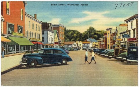 c. 1930
 c. 1930
 c. 1930
 c. 1930
 c. 1930
 c. 1930
 c. 1930
 c. 1930
 1930s
 1984
 1984
 2012
 2012
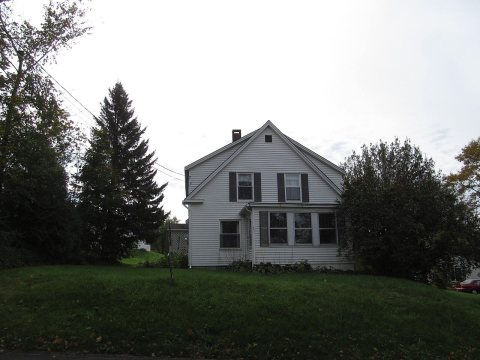 2012
 2012
 2012
 2012
 2012
 2012
 2012
 2012
 2012
 2012
 2007


