The story
Read it all →How Westport Island came to be
From Wikipedia’s history of Westport Island.
The town was part of Edgecomb before being separately incorporated in 1828.
Text from Wikipedia, licensed CC BY-SA 4.0.
Each edition grades its towns against each other only.
4 places in town are on the National Register. Below: 1 old photo or paper, maps from 1893 on, and the census since 1830.
Read from the archive, the National Register and the record. The page puts what stands out first.
The first neighbors to add old photos shape how Westport Island’s history is told.
Lost two-thirds of its people between 1860 and 1930, then grew 6-fold.
20 censuses, 1830–2020.
U.S. Census Bureau decennial counts, from the census table on Westport Island’s Wikipedia page.
Another post office, Westport, opened and closed inside today’s town.
Bailey Sewall Cemetery · Bartlett Webber Cemetery · Booth Harrison Ward Cemetery · Bruce Pierce - Alden Jewett Cemetery · Cameron - Joseph Hodgdon Cemetery · Captain George P Parsons Cemetery · Captain Henry Dunton Cemetery · Charles Cromwell Cemetery · Cornelius Tarbox Cemetery · Dunton Gilmore Cemetery · East Side Cemetery · Ezekiel Tarbox Cemetery · Fowles Ames Skinner Cemetery · Greenleaf Cemetery 1 · Greenleaf Cemetery Number 03 · Harriman Mitchell Stacy Cemetery · Heal Shattuck Cemetery · Henry Kehail Cemetery · Hodgdon Cemetery · Hodgdon Dunton Dickson Cemetery · Jacob Dunton Cemetery · James Jewett Cemetery · James McCarty Cemetery · Jewett Nelson Blake Moore Cemetery · Jewett Schweppe Cemetery · John Moore Cemetery · Jonas S Knight Cemetery · Jonathan Fowle Cemetery · Jordan Tarbox Cemetery · Kehail Cemetery · Manson Dunton Cemetery · McKinney and Colby Cemetery · McKinney Daughters Cemetery · Nathan Hodgdon Cemetery · Nehemiah Colby Cemetery · Old Brooks Cemetery · Parsons Cromwell Colby Cemetery · Parsons Greenleaf Cemetery · Rines - Ken Parsons Cemetery · Samuel Tarbox Junior Cemetery · Shea Cemetery · Stephen Jewett Cemetery · Stephen Knight Cemetery · Tarbox Cemetery · Thomas Brooks Cemetery · Thomas Knight Cemetery · Tyler Whitten Freeman Cemetery · Whitten Lewis Cemetery · William Knight Cemetery · Willis Harrington Cemetery
US Post Offices dataset (Blevins & Helbock, CC0). Places and cemeteries from the USGS Geographic Names Information System (2021).
From Wikipedia’s history of Westport Island.
The town was part of Edgecomb before being separately incorporated in 1828.
Text from Wikipedia, licensed CC BY-SA 4.0.
Woven from the archive, old maps, post office records, the National Register and the people born here.
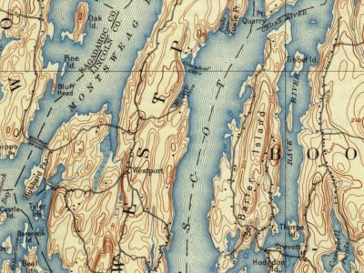 On the mapFirst mapped by the U.S. Geological Survey
Every edition of the U.S. Geological Survey’s map of Westport Island. Tap a year, or press play to watch the town change.

U.S. Geological Survey historical topographic maps (public domain), via Esri’s collection of the scans. The red ring marks the center of Westport Island.
No then-and-now pairs yet. Take a photo from the same spot as an old one and they appear here side by side.

Find the spot, match the angle, and add your photo. It becomes the first then-and-now pair on Westport Island’s page.
Retake this view · +15The country’s official list of buildings and places worth saving.
National Park Service, National Register of Historic Places. Photos from Wikimedia Commons, credited on each place’s page.
Each neighbor’s History grade, on the same three inputs.
4 listings: 4 buildings, among them the Josiah K. Parsons Homestead (listed 1982, the first). 5 historic buildings in all.
What the archives can’t tell you, neighbors can.
Founding dates: Wikidata, Wikipedia, the U.S. post office records of Blevins & Helbock (CC0) and the Census. Homes by year built: Census ACS 2020–24. National Register of Historic Places: National Park Service (list of May 22, 2026). Old photos, postcards and papers: Wikimedia Commons, the Library of Congress and other public archives, credited on each item’s page. Maps: U.S. Geological Survey historical topographic maps (via Esri) and Sanborn fire-insurance maps (Library of Congress). History text and census tables: Wikipedia (CC BY-SA 4.0). Places that used to be: USGS Geographic Names Information System (2021). How TownRatings grades history →
From Wikimedia Commons (2), the Library of Congress (1), the National Register of Historic Places (4), Wikipedia, U.S. Geological Survey historical maps, U.S. Census counts (via Wikipedia), the US Post Offices dataset (Blevins & Helbock) and the USGS Geographic Names Information System. Archive images are copied here with their credits and licenses, shown on each photo’s page. Refreshed monthly.
 Date?
 2013
 2013


