Mechanic Falls dates to 1893, and 25% of its homes were built before 1940
More historic than 60% of U.S. towns · #116 of 143 in Maine. What drives it
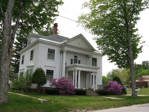
Its Register listings are the Elms, the George Seaverns House and the Samuel Penney House. Below: 14 old photos and papers, maps from 1885 on, and the census since 1900.
On its age, its old homes and the National Register, Mechanic Falls is more historic than 60% of U.S. towns, #116 of 143 in Maine. Its share of homes from before 1940 holds the grade up; its age pulls it down.
B
HistoryA character grade: shown, never part of Mechanic Falls’ overall grade.
Maine towns list more on the Register than most of the country (a typical Maine town has 15.9 per 10,000 residents, the U.S. 2.4), so Mechanic Falls’ 9.6 sits near the middle of its state (40% of Maine towns have fewer) while its 3 listings outnumber those of 65% of U.S. towns.
NoteThe founding year comes from Wikidata alone; no second source gives 1893.
How sure. Graded on any two of the three inputs instead, the letter would range from C to B+. The pre-1940 share is a Census survey estimate (±11.4 points).
Founding year: Wikidata (other dates in Quick answers). Homes: Census ACS 2020–24. National Register: National Park Service, May 2026 list; each listing counted once (boundary changes and added documentation belong to their listing), and a historic district counts its contributing buildings. How TownRatings grades history →
What stands out about Mechanic Falls’ past
Read from the archive, the National Register and the record. The page puts what stands out first.
Fire insurance maps drew every building, what it was made of and what it was used for, so insurers could price the risk of fire. Pick a year, then a sheet.
1885Sheet 1 of 1
Edition
Sheets
BrickWoodStone
Sanborn Map Company, via the Library of Congress. Editions published in 1930 or earlier, which are in the public domain.
By decade
Mechanic Falls, decade by decade
7 decades in the archive, from the 1860s to the 1920s. Scroll each row; tap a photo for its story.
Nothing in the archives for these yearsWeddings on Main Street, storms, parades, school pictures, the old store. If it’s in your family album, it belongs here.
Every edition of the U.S. Geological Survey’s map of Mechanic Falls. Tap a year, or press play to watch the town change.
1908Poland sheet · 1:62,500
U.S. Geological Survey historical topographic maps (public domain), via Esri’s collection of the scans. The red ring marks the center of Mechanic Falls.
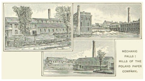
The town was originally part of Bakerstown Plantation, granted in 1765 by the Massachusetts General Court to Captain Thomas Baker and other soldiers for their services in the 1690 Battle of Quebec. In 1795, Bakerstown Plantation was incorporated as Poland, from which Minot would be set off in 1802. The dividing line between the towns was the Little Androscoggin River, astride which the village of Mechanic Falls developed. The Poland section of Mechanic Falls was settled in 1830, and the Minot in 1836 by Dean Andrews, who was drawn by its fine soil for farming and waterpower for mills at the falls. Mechanic Falls developed into a small mill town named for the mechanics operating early industrial works here, especially after the St. Lawrence and Atlantic Railroad arrived in the late 1840s. The railroad opened the village to business and trade on the direct line between Portland and Montre…
Passages that mention Mechanic Falls, cut from the printed page as they were published.
History of Androscoggin County, Maine ..1891 · page 770Read the page →
Read the text
bulated. November 13, Oxford town line perambulated. 1883, William Lord, aged 93, died. He was a pensioner of the War of 1812 and the oldest man in town. 1884, September 8, voted 241 for, 51 against, the prohibitory amendment to the constitution. 1888, March 5, the selectmen were instructed to build a lock-up at Mechanic Falls, either alone or in connection with the town of Poland. 1891, voted to raise $3,000 in money for highways, $2,000 for schools, $500 for culverts and bridges, .$25 for Memorial Day, $1,500 for poor, $600 for town oflflcer's bills, $500 for text-books, $800 for a free high school, $1,000 to pay indebtedness, $800 to pay interest, $1,000 to build a bridge at Hackett's Mills in
Text read by machine from the scan; it may contain errors.
History of Androscoggin County, Maine ..1891 · page 95Read the page →
Read the text
Railroads. — The Grand Trunk Railway in Maine is the successor of the Atlantic and St Lawrence Railroad Company, incorporated by the State Legislature February 10, 1845. This road was completed to Mechanic Falls, thirtyseven miles, in the autumn of 1848. The Grand Trunk leased this road, in 1853, at a rental of six per cent, on the cost of construction of the oiie hundred and forty-nine miles from Portland to Island Pond — $6,003,900. This road has done much to develop the resources of the country along its line, and has created several prosperous villages. In Maine it operates under a lease, the
Text read by machine from the scan; it may contain errors.
Scans and text from the Internet Archive. Books published in 1930 or earlier, which are in the public domain.
Timeline
Mechanic Falls, 1841 to 1920
Woven from the archive, old maps, post office records, the National Register and the people born here.
In 1893, according to Wikidata. the census of 1900 counted 1,687 people here.
How does Mechanic Falls rank for history?
Mechanic Falls is more historic than 60% of U.S. towns, #116 of 143 in Maine. The History grade combines the town’s founding era, the share of homes built before 1940 and its National Register listings. It’s a character grade, so it isn’t part of the overall grade. How it works.
What is on the National Register in Mechanic Falls?
Three places: the Elms (listed 1985), the George Seaverns House (1985) and the Samuel Penney House (2002).
How old are the homes in Mechanic Falls?
25% of Mechanic Falls’ homes were built before 1940 (Census estimate, ±11.4 points), against a typical 19% for a Maine town; the median home was built in 1980.
Founding dates: Wikidata, Wikipedia, the U.S. post office records of Blevins & Helbock (CC0) and the Census. Homes by year built: Census ACS 2020–24. National Register of Historic Places: National Park Service (list of May 22, 2026). Old photos, postcards and papers: Wikimedia Commons, the Library of Congress and other public archives, credited on each item’s page. Maps: U.S. Geological Survey historical topographic maps (via Esri) and Sanborn fire-insurance maps (Library of Congress). History text and census tables: Wikipedia (CC BY-SA 4.0). Places that used to be: USGS Geographic Names Information System (2021).
From Wikimedia Commons (17), the National Register of Historic Places (3), Wikipedia, Wikidata and Wikipedia for famous people, U.S. Geological Survey historical maps, U.S. Census counts (via Wikipedia), the USGS Geographic Names Information System, Sanborn fire insurance maps (Library of Congress) and old county and town histories (Internet Archive). Archive images are copied here with their credits and licenses, shown on each photo’s page. Refreshed monthly.


 c. 1869
 c. 1869
 1875
 1875
 1878
 1880
 1887
 1891
 1900
 1913
 1913
 1913
 1913
 c. 1922
 2012
 2012
 2008