Limerick dates to 1775, and 3 of its places are on the National Register
More historic than 80% of U.S. towns · #77 of 143 in Maine. What drives it
Most of Limerick was built recently: 4% of its homes predate 1940 and the median home dates from 1994. 3 places in town are on the National Register, among them a historic district with 22 buildings. Below: 6 old photos and papers, maps from 1891 on, and the census since 1790.
Founding year: Wikidata. First post office: 1797.The full story ↓
History grade
What drives Limerick’s History grade
On its age, its old homes and the National Register, Limerick is more historic than 80% of U.S. towns, #77 of 143 in Maine. Its age holds the grade up; its share of homes from before 1940 pulls it down.
A−
HistoryA character grade: shown, never part of Limerick’s overall grade.
Maine towns list more on the Register than most of the country (a typical Maine town has 15.9 per 10,000 residents, the U.S. 2.4), so Limerick’s 70.6 sits above most of its state (81% of Maine towns have fewer) while its 24 historic buildings outnumber those of 80% of U.S. towns.
NoteThe founding year comes from Wikidata alone; no second source gives 1775.
How sure. Graded on any two of the three inputs instead, the letter would range from B to A+. The pre-1940 share (±2.7 points) is firm at this size.
Founding year: Wikidata (other dates in Quick answers). Homes: Census ACS 2020–24. National Register: National Park Service, May 2026 list; each listing counted once (boundary changes and added documentation belong to their listing), and a historic district counts its contributing buildings. How TownRatings grades history →
What stands out about Limerick’s past
Read from the archive, the National Register and the record. The page puts what stands out first.
This was territory of the Newichewannock Abenaki people, whose village was located on the Salmon Falls River. In 1668, Francis Small of Kittery, a trader, bought from Chief Captain Sunday (or Wesumbe) a large tract of land, for which he exchanged two blankets, two gallons of rum, two pounds of gunpowder, four pounds of musket balls and twenty strings of beads. Small thereupon sold half of his interest to Major Nicholas Shapleigh of Eliot, one of the wealthiest merchants in the Piscataqua region.
Passages that mention Limerick, cut from the printed page as they were published.
History of York County, Maine. With illustrations and biographical sketches of its prominent men and pioneers1880Read the page →
Read the text
town of Limerick; thence north 22i degrees west, five and one-fourth miles to the northeasterly corner of said town of Limerick ; thence north 25 degrees east to the southwest corner of a lot of land containing about GOO acres, formerl}- granted to Theophilus Bradbury, Esq.; thence north to the place of beginning, at Saco River.
Text read by machine from the scan; it may contain errors.
History of York County, Maine. With illustrations and biographical sketches of its prominent men and pioneers1880 · page 198Read the page →
Read the text
being was gone. Having become early in life accustomed to the use of the axe, saw, shovel, and plow, he could handle them if necessity required equal, if not superior, to most men. In 1772 the town of Limerick was located, in which he had a share, and the proprietors named it in honor of the town in Ireland from which his father emigrated. As nothing better offered, he would take his axe, week's provision, blanket, frock, and trowsers, and with other settlers
Text read by machine from the scan; it may contain errors.
1857 Joshua Holland purchased property and founded the Holland Mills. 1899 Limerick Mills for yarn manufacture incorporated. 1851 Limerick House erected by Robert Cole on site of the Bradbury Inn.
Text read by machine from the scan; it may contain errors.
Limerick had not only militia but an artillery companv, founded 1836. Cannon Hill is so named because the cannon was mounted there. Peter Fogg made the cartridges for training day, and had charge of the powder house on the ledge near the lower cemetery.
Text read by machine from the scan; it may contain errors.
Scans and text from the Internet Archive. Books published in 1930 or earlier, which are in the public domain.
Timeline
Limerick, 1775 to 2020
Woven from the archive, old maps, post office records, the National Register and the people born here.
Nothing in the archives for these yearsWeddings on Main Street, storms, parades, school pictures, the old store. If it’s in your family album, it belongs here.
In 1775, according to Wikidata. Limerick’s post office opened in 1797, and the first U.S. census counted 409 people here in 1790.
How does Limerick rank for history?
Limerick is more historic than 80% of U.S. towns, #77 of 143 in Maine. The History grade combines the town’s founding era, the share of homes built before 1940 and its National Register listings. It’s a character grade, so it isn’t part of the overall grade. How it works.
What is on the National Register in Limerick?
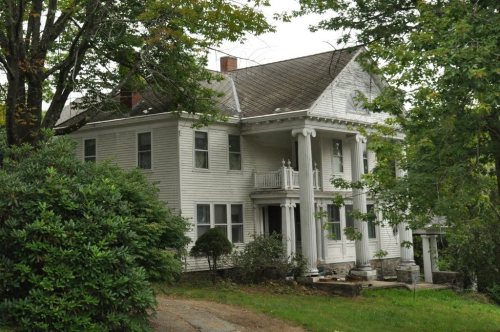
Three places: the Limerick Upper Village Historic District (listed 1984), the Sunnycroft (1984) and the Harper Family House (1998).
How old are the homes in Limerick?
4% of Limerick’s homes were built before 1940 (Census estimate, ±2.7 points), against a typical 19% for a Maine town; the median home was built in 1994.
Founding dates: Wikidata, Wikipedia, the U.S. post office records of Blevins & Helbock (CC0) and the Census. Homes by year built: Census ACS 2020–24. National Register of Historic Places: National Park Service (list of May 22, 2026). Old photos, postcards and papers: Wikimedia Commons, the Library of Congress and other public archives, credited on each item’s page. Maps: U.S. Geological Survey historical topographic maps (via Esri) and Sanborn fire-insurance maps (Library of Congress). History text and census tables: Wikipedia (CC BY-SA 4.0). Places that used to be: USGS Geographic Names Information System (2021).
From Wikimedia Commons (14), Wikidata (3), the National Register of Historic Places (3), Wikipedia, Wikidata and Wikipedia for famous people, U.S. Geological Survey historical maps, U.S. Census counts (via Wikipedia), the US Post Offices dataset (Blevins & Helbock), the USGS Geographic Names Information System and old county and town histories (Internet Archive). Archive images are copied here with their credits and licenses, shown on each photo’s page. Refreshed monthly.




 c. 1915
 c. 1915
 c. 1915
 c. 1915
 2018
 2018
 2016
 2016
 2015
 2015
 2014
 2008

