Hancock dates to 1766, and 23% of its homes were built before 1940
More historic than 90% of U.S. towns · #48 of 143 in Maine. What drives it
Its Register listings are the Nazi Spy Landing Site, the Hancock Point School and the Crosby Lodge. Below: 6 old photos and papers, maps from 1981 on, and the census since 1790.
Founding year: Wikidata; Wikipedia’s history section gives the same year. First post office: 1828.The full story ↓
History grade
What drives Hancock’s History grade
On its age, its old homes and the National Register, Hancock is more historic than 90% of U.S. towns, #48 of 143 in Maine. All 3 inputs are above most U.S. towns; its age ranks highest and its National Register listings lowest.
A
HistoryA character grade: shown, never part of Hancock’s overall grade.
Maine towns list more on the Register than most of the country (a typical Maine town has 15.9 per 10,000 residents, the U.S. 2.4), so Hancock’s 15.9 sits near the middle of its state (52% of Maine towns have fewer) while its 4 historic buildings outnumber those of 68% of U.S. towns.
How sure. Graded on any two of the three inputs instead, the letter would range from A− to A. The pre-1940 share is a Census survey estimate (±8.3 points). Two sources give 1766.
Founding year: Wikidata (other dates in Quick answers). Homes: Census ACS 2020–24. National Register: National Park Service, May 2026 list; each listing counted once (boundary changes and added documentation belong to their listing), and a historic district counts its contributing buildings. How TownRatings grades history →
What stands out about Hancock’s past
Read from the archive, the National Register and the record. The page puts what stands out first.
Hancock was settled in 1766 by Philip and S. Hodgkins from Georgetown, Maine, formed from portions of Sullivan, Trenton, and Plantation No. 8. The town was incorporated by the state legislature on February 21, 1828 and named for John Hancock, signer of the Declaration of Independence. The Kilkenny and Egypt streams offered water power for mills. There was one gristmill, four shingle mills, and four lath mills. Other products included barrel staves, lumber, boots, shoes, wagons, and sleighs. Many inhabitants were engaged in seafaring, particularly fishing at the Grand Banks.
present homestead, which was then within the limits of Trenton. His paternal grandfather, William Hodgkins, was a pioneer of both the county and town of Hancock. In the latter William reclaimed a farm from the wilderness, and on it spent his remaining years.
Text read by machine from the scan; it may contain errors.
and fraternal organizations of the place, and in an official capacity has done much to promote their advancement and usefulness. In 1873 he founded the Hancock County Savings Bank, of which he has always been president; and at one time was also treasurer, and of which his son, who was not born at the time of its incorporation, is now a director. He
Text read by machine from the scan; it may contain errors.
Scans and text from the Internet Archive. Books published in 1930 or earlier, which are in the public domain.
By decade
Hancock, decade by decade
2 decades in the archive, from the 1900s to the 1910s. Scroll each row; tap a photo for its story.
Nothing in the archives for these yearsWeddings on Main Street, storms, parades, school pictures, the old store. If it’s in your family album, it belongs here.
In 1766, according to Wikidata and Wikipedia’s history of the town. Hancock’s post office opened in 1828, and the first U.S. census counted 278 people here in 1790.
How does Hancock rank for history?
Hancock is more historic than 90% of U.S. towns, #48 of 143 in Maine. The History grade combines the town’s founding era, the share of homes built before 1940 and its National Register listings. It’s a character grade, so it isn’t part of the overall grade. How it works.
What is on the National Register in Hancock?
Three places: the Nazi Spy Landing Site (listed 2003), the Hancock Point School (2013) and the Crosby Lodge (2025).
How old are the homes in Hancock?
23% of Hancock’s homes were built before 1940 (Census estimate, ±8.3 points), against a typical 19% for a Maine town; the median home was built in 1987.
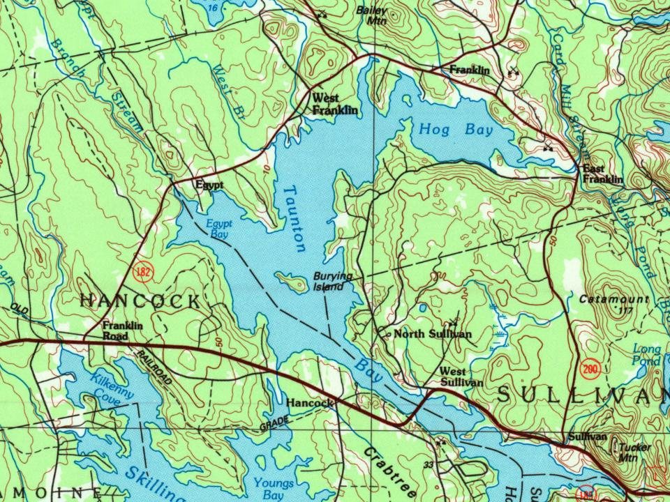
Founding dates: Wikidata, Wikipedia, the U.S. post office records of Blevins & Helbock (CC0) and the Census. Homes by year built: Census ACS 2020–24. National Register of Historic Places: National Park Service (list of May 22, 2026). Old photos, postcards and papers: Wikimedia Commons, the Library of Congress and other public archives, credited on each item’s page. Maps: U.S. Geological Survey historical topographic maps (via Esri) and Sanborn fire-insurance maps (Library of Congress). History text and census tables: Wikipedia (CC BY-SA 4.0). Places that used to be: USGS Geographic Names Information System (2021).
From Wikimedia Commons (3), the Library of Congress (3), the National Register of Historic Places (3), Wikipedia, U.S. Geological Survey historical maps, U.S. Census counts (via Wikipedia), the US Post Offices dataset (Blevins & Helbock), the USGS Geographic Names Information System and old county and town histories (Internet Archive). Archive images are copied here with their credits and licenses, shown on each photo’s page. Refreshed monthly.


 1908
 c. 1908
 c. 1908
 1912