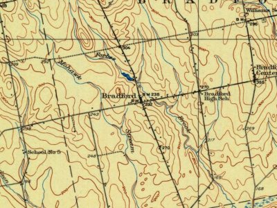
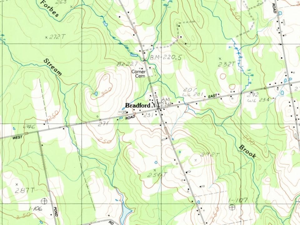
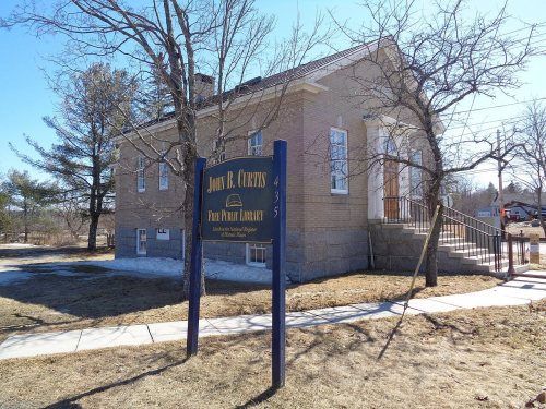
Most of Bradford was built recently: 9% of its homes predate 1940 and the median home dates from 1985. Its Register listing is the Curtis, John B., Free Public Library. Below: maps from 1933 on and the census since 1840.
Founding year: Wikipedia. First post office: 1821.The full story ↓
History grade
What drives Bradford’s History grade
On its age, its old homes and the National Register, Bradford is more historic than 58% of U.S. towns. Its age holds the grade up; its share of homes from before 1940 pulls it down.
B
HistoryA character grade: shown, never part of Bradford’s overall grade.
Maine towns list more on the Register than most of the country (a typical Maine town has 15.9 per 10,000 residents, the U.S. 2.4), so Bradford’s 8.0 sits near the middle of its state (36% of Maine towns have fewer) while its 1 listings outnumber those of 51% of U.S. towns.
How sure. Graded on any two of the three inputs instead, the letter would range from C+ to B. The pre-1940 share is a Census survey estimate (±4.7 points). Two sources give 1820.
Founding year: Wikipedia (other dates in Quick answers). Homes: Census ACS 2020–24. National Register: National Park Service, May 2026 list; each listing counted once (boundary changes and added documentation belong to their listing), and a historic district counts its contributing buildings. How TownRatings grades history →
What stands out about Bradford’s past
Read from the archive, the National Register and the record. The page puts what stands out first.
According to some early documents, Bradford was said to be first settled between 1803 and 1805 by James White and Robert Marshall of Thomaston however early settler Cornelius Bradford was among the first to live in the settlement and died there in 1790. Cornelius Bradford is a lineal descendant of Governor William Bradford of the Plymouth Colony. He was the eldest child of Joshua and Hannah Bradford, who were killed during the Raid on Meduncook. Bradford was organized as Blakesburg Plantation in 1820 and was incorporated as a town on March 12, 1831. By the mid-1850s its population had peaked at 1,500, which is about 200 more people than it has today.
Passages that mention Bradford, cut from the printed page as they were published.
History of Penobscot County, Maine1882 · page 252Read the page →
Read the text
For about eleven years this answered the needs of the rather sparse population, and then the town of Bradford was incorporated. The date of this act was March 12, 1831. It has since become one of the most populous towns of the county. In 1830, the year before incorporation as a town, Blakesburgh Plantation had a population of four hundred and three. Ten years thereafter Bradford town had 1,000 people; in 1850, r, 296; in i860,
Text read by machine from the scan; it may contain errors.
History of Penobscot County, Maine1882 · page 252Read the page →
Read the text
For about eleven years this answered the needs of the rather sparse population, and then the town of Bradford was incorporated. The date of this act was March 12, 1 83 1. It has since become one of the most populous towris of the county. In 1830, the year before incorporation as a town, Blakesburgh Plantation had a population of four hundred and three. Ten years thereafter Bradford town had 1,000 people; in 1850, 1,296; in i860,
Text read by machine from the scan; it may contain errors.
History of Penobscot County, Maine1882 · page 401Read the page →
Read the text
On the 23d of August, 1841, the first church in this town was organized as a branch of the Free-will Baptist church of Bradford. Some years previous to this the Methodists had for a time what is called in their polity s "class," but no church organization was entered into.
Text read by machine from the scan; it may contain errors.
History of Penobscot County, Maine1882 · page 279Read the page →
Read the text
and about a mile north of this still another runs about half-way across, stopping at its intersection with the north and south road through Charleston post-office. A similar highway enters from Bradford, and stops at the same road, a little more than a mile south of the central route. A shorter road, but with the same general direction, is still south of this, and connects the north and south road in the east of the town with a road to the
Text read by machine from the scan; it may contain errors.
Scans and text from the Internet Archive. Books published in 1930 or earlier, which are in the public domain.
Timeline
Bradford, 1820 to 1933
Woven from the archive, old maps, post office records, the National Register and the people born here.
In 1820, according to Wikipedia’s history of the town. Bradford’s post office opened in 1821, and the census of 1840 counted 1,000 people here.
How does Bradford rank for history?
Bradford is more historic than 58% of U.S. towns. The History grade combines the town’s founding era, the share of homes built before 1940 and its National Register listings. It’s a character grade, so it isn’t part of the overall grade. How it works.
What is on the National Register in Bradford?
One place: the Curtis, John B., Free Public Library (listed 1997).
How old are the homes in Bradford?
9% of Bradford’s homes were built before 1940 (Census estimate, ±4.7 points), against a typical 19% for a Maine town; the median home was built in 1985.
Founding dates: Wikidata, Wikipedia, the U.S. post office records of Blevins & Helbock (CC0) and the Census. Homes by year built: Census ACS 2020–24. National Register of Historic Places: National Park Service (list of May 22, 2026). Old photos, postcards and papers: Wikimedia Commons, the Library of Congress and other public archives, credited on each item’s page. Maps: U.S. Geological Survey historical topographic maps (via Esri) and Sanborn fire-insurance maps (Library of Congress). History text and census tables: Wikipedia (CC BY-SA 4.0). Places that used to be: USGS Geographic Names Information System (2021).
From the National Register of Historic Places (1), Wikipedia, U.S. Geological Survey historical maps, U.S. Census counts (via Wikipedia), the US Post Offices dataset (Blevins & Helbock), the USGS Geographic Names Information System and old county and town histories (Internet Archive). Archive images are copied here with their credits and licenses, shown on each photo’s page. Refreshed monthly.