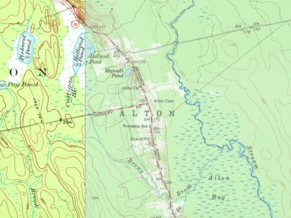
Most of Alton was built recently: 6% of its homes predate 1940 and the median home dates from 1988. Below: maps from 1917 on and the census since 1850.
The Alton post office opened in 1846, the earliest record of the town by name. Another post office, Gerry (1895), opened inside today’s town and later closed.
First census: 252 in 18502020 census: 829180 years
Founding year: the first Alton post office (Blevins & Helbock, CC0).
What stands out about Alton’s past
Read from the archive, the National Register and the record. The page puts what stands out first.
Lost half of its people between 1860 and 1920, then grew 3-fold.
18 censuses, 1850–2020.
U.S. Census Bureau decennial counts, from the census table on Alton’s Wikipedia page.
On the map
Alton on the map, 1917 to 1988
Every edition of the U.S. Geological Survey’s map of Alton. Tap a year, or press play to watch the town change.
1917Passadumkeag sheet · 1:62,500
U.S. Geological Survey historical topographic maps (public domain), via Esri’s collection of the scans. The red ring marks the center of Alton.
The story so far
Alton, in brief
Wikipedia doesn’t have a history of Alton yet. The photos, dates and memories neighbors add here are how it gets written.
Alton is a town in Penobscot County, Maine, United States. It is part of the Bangor Metropolitan Statistical Area. The population was 829 at the 2020 census. The community is named after an Alton in England.
Its first post office opened in 1846. Between the 2010 and 2020 censuses its population fell from 890 to 829 (-7%).
Intro from Wikipedia. Population: U.S. Census Bureau.
From the old history books
What they wrote about Alton in 1882
Passages that mention Alton, cut from the printed page as they were published.
of the Penobscot pioneer of 1769, who built the first house in Bangor. Another old settler was William Foster, of Bradley, a pioneer of i<Si5. The Plantation, then including Alton also, was incorporated as a town March 19, 1839, and the town of Argyle was reduced to its present dimensions by the carving from its territory of the town of Alton, March 9, 1844. This will account for the reduction of its population from 527 in 1840 to
Text read by machine from the scan; it may contain errors.
History of Penobscot County, Maine1882 · page 250Read the page →
Read the text
of the Penobscot pioneer of 1769, who built the first house in Bangor. Another old settler was William' Foster, of Bradley, a pioneer of 18x5. The Plantation, then including Alton also, was incorporated as a town March 19, 1839, and the town of Argyle was reduced to its present dimensions by the carving from its territory of the town of Alton, March 9, 1844. This will account for the reduction of its population from 527 in 1840 to
Text read by machine from the scan; it may contain errors.
History of Penobscot County, Maine1882 · page 248Read the page →
Read the text
Alton was originally a part of the Argyle Plantation, which extended to the Penobscot, and was subsequently a part of Argyle town. Five years after the erection of the latter — that is to say, on the 9th of March, 1844 — the present town was set off from Argyle under the name of Alton. Its population at that lime was not far from 200. By the census of 1850 it had 252 people; by that of i860, it had 531; of 1870, 508; and in 1880,
Text read by machine from the scan; it may contain errors.
History of Penobscot County, Maine1882 · page 455Read the page →
Read the text
gor & Piscataquis Railroad, which forms a junction with it at Oldtown, and runs west of north about five and onehalf miles in this town, crossing Orson Island en roiiti, and running into Alton. A mile before its e.xit it makes a station at the crossing of the wagon-road for Pea Cove, which station has a name to correspond. This is the only station of this road in the town, e.xcept at the village.
Text read by machine from the scan; it may contain errors.
Scans and text from the Internet Archive. Books published in 1930 or earlier, which are in the public domain.
Timeline
Alton, 1846 to 2010
Woven from the archive, old maps, post office records, the National Register and the people born here.
Founding dates: Wikidata, Wikipedia, the U.S. post office records of Blevins & Helbock (CC0) and the Census. Homes by year built: Census ACS 2020–24. National Register of Historic Places: National Park Service (list of May 22, 2026). Old photos, postcards and papers: Wikimedia Commons, the Library of Congress and other public archives, credited on each item’s page. Maps: U.S. Geological Survey historical topographic maps (via Esri) and Sanborn fire-insurance maps (Library of Congress). History text and census tables: Wikipedia (CC BY-SA 4.0). Places that used to be: USGS Geographic Names Information System (2021). How TownRatings grades history →
From U.S. Geological Survey historical maps, U.S. Census counts (via Wikipedia), the US Post Offices dataset (Blevins & Helbock), the USGS Geographic Names Information System and old county and town histories (Internet Archive). Archive images are copied here with their credits and licenses, shown on each photo’s page. Refreshed monthly.